Issue Date: Monday, August 9th, 2021
Issue Time: 3:05PM MDT
Valid Dates: 8/10 – 8/24
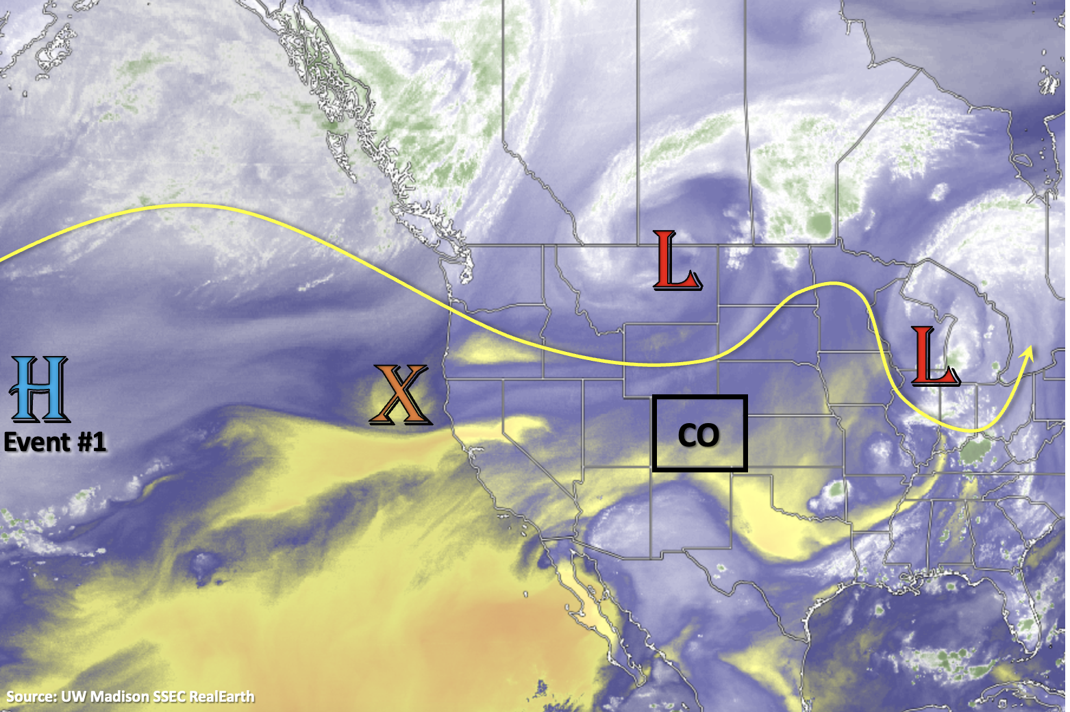
It has been pretty much bone dry, hot and smoky since last week, after quite a prolonged monsoon event. More of the heat and smoke is on tap for the first part of this week before our next shot at rainfall. This will occur as the High pressure begins to build over the western US again behind the trough marked below. An elongated and strong ridge, oriented from northwest to southeast, will begin to pull subtropical moisture northward into the state by Friday and help produce some hot temperatures this week. Then another incoming shortwave (Friday into Saturday) will help to shift the ridge eastward, putting Colorado in a favorable position for a stronger moisture surge by mid-weekend.
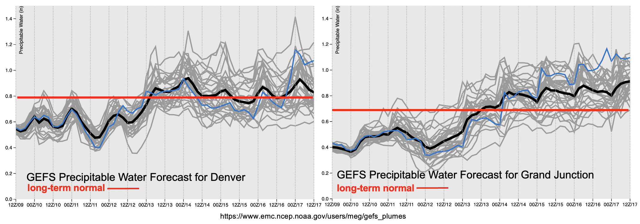
Once again we will see dry conditions both east and west of the Continental Divide as shown by PW values remaining well-below average. Then, there’s a strong upturn in moisture to more seasonable values by Thursday night and a likely surge to above average PW values by this weekend. The mid-level energy moving through the flow in a moisture-rich environment will help to spark more numerous storms over the mountains and increase the threat for a couple of severe thunderstorms with the main threat being strong outflow winds. Steering flows through early next week look to be on the lower-end, which will aid in increasing the flood threat. Therefore, an Elevated flood threat has been issued. Keep scrolling below to read more details about the events for this FTO.
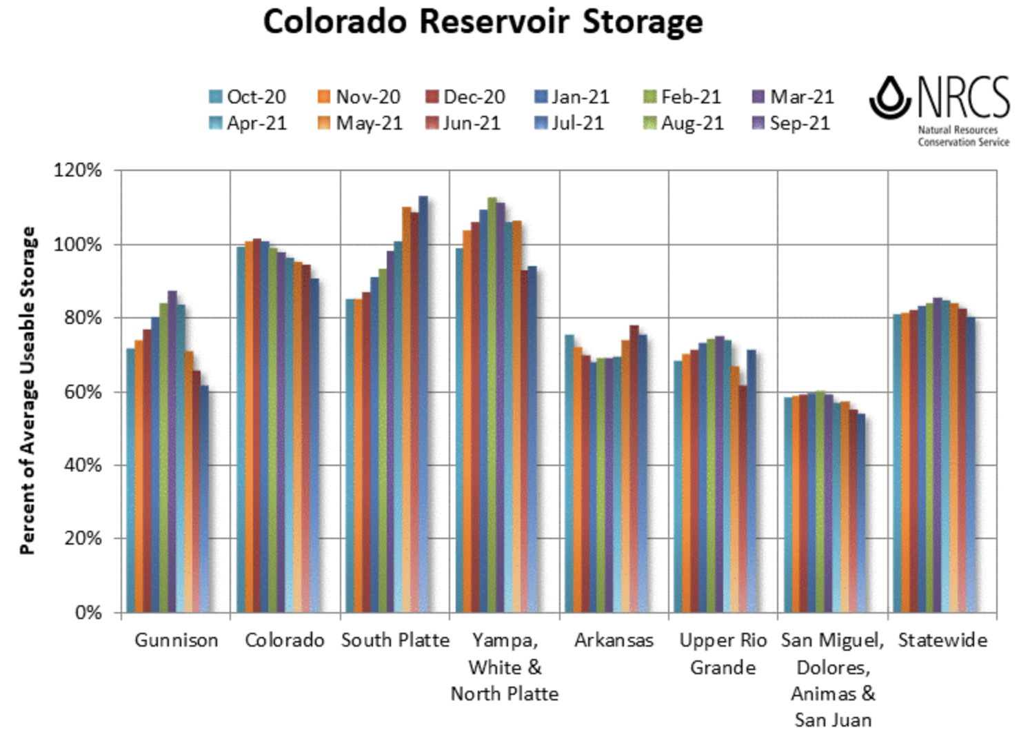
Below is the Colorado average reservoir storage (%) separated by river basin through July 2021. There has been a steady decrease in usable storage over the Gunnison, Colorado and San Juan River Basins throughout the warm season. Storage has been steady over Yampa/White River Basin the last two months with increases in average storage over the South Platte and Upper Rio Grande. Statewide, we are still at 80% of average usable storage. Below that image is the state precipitation ranks for July. As you can see over the Southwest US, it has been an active North American Monsoon (NAM) with most states receiving much above average rainfall. The NAM helped Colorado reach near average precipitation. The southwest, central and southeast mountains received above average precipitation for July, and below average precipitation was recorded over the eastern plains and portions of the Northwest Slope and Northern Mountains. We’re not quite done with the NAM yet, so looking forward to getting rainfall back in the forecast this weekend.
![]()
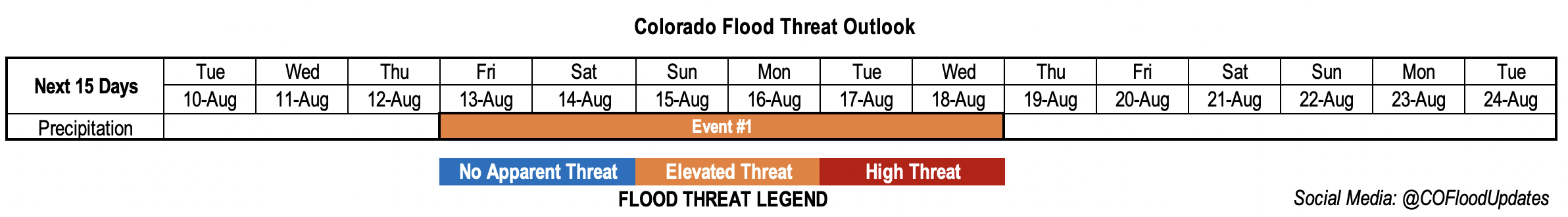
Event #1: Friday – Wednesday (8/13 – 8/18)
Elevated flood threat as the next monsoon moisture surge moves into the state.
Monsoon moisture should reach the state by late Thursday into Friday. Except more scattered storms first across the San Juan, Central and Front Range Mountains. Then as the ridge axis gets pushed eastward and flow becomes more southwesterly on Sunday, expect showers pick up in intensity and coverage over the San Juan, Central and Southeast Mountains. Extra mid-level energy and a weak frontal passage will help to spark more numerous storms. There perhaps could be some heavy rainfall activity over the Southeast Plains earlier in the weekend. Monday into the middle of next week, the state will be sandwiched between a trough to our northwest and strong High pressure center over the Midwest. This should keep moisture streaming across the state, and storms should become more numerous over western Colorado during this period. It’s likely that as the next trough passes to our north sometime at the end of next week, the moisture will be cut off and we’ll get another break in rainfall. Due to the slower steering flows, high moisture and extra mid-level energy for this event an Elevated flood threat has been issued. Expect a peak in heavy rainfall activity from Sunday into early next week for this event, and tune back into the FTO on Thursday for the latest.