Issue Date: Thursday, August 5th, 2021
Issue Time: 9:50 AM MDT
Summary:
Another early start to precipitation yesterday, this time east of the divide and on the Eastern Plains and Palmer Ridge due to the slow-moving eastward progress of the upper-level trough. As the afternoon progressed, daytime heating allowed for greater convective storms to develop, with higher rainfall rates across the Southeast Plains.
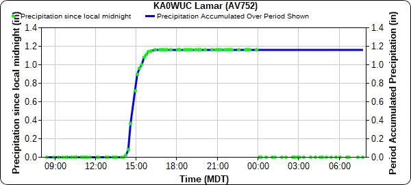
Lamar in the Southeast Plains experienced heavy rain and flooding associated with these storms yesterday afternoon. Several precipitation reports exceeded 1 inch, including 1.16 from a APRSWXNET/CWOP station, 1.14 from a CoCoRaHS observer, and 1.22 from a public report to law enforcement. Flash flood warnings were issued for both the City of Lamar and John Martin Reservoir yesterday.
Some notable flood reports mention “water in ditches everywhere” and “flooding at intersection of Main Street and Olive Street”. The water in the streets was deep enough to require traffic redirection from law enforcement. The following video shared by Weather Nation on twitter shows some of the deep water in town.
Lamar Colorado was under a flash flood warning today with 1-1.5"+ rainfall totals.
This parking lot was one of those spots that dealt with it #COwx pic.twitter.com/admNZpMcSo
— WeatherNation (@WeatherNation) August 5, 2021
According to the APRSWXNET/CWOP station, all of the precipitation that fell yesterday came in a 2-hour window (time series plot below). Precipitation Frequency estimates from NOAA Atlas 14 for Lamar indicate the 1-year, 2-hour Average Recurrence Interval precipitation is 1.14. So while flooding did occur as a result of heavy rain, this amount of rain is expected to occur at least once a year in this portion of the state.
On the western half of the state, including the Front Range Mountains and Urban Corridor, dry air filled in behind the exit of the trough, leaving behind more seasonably warm temperature and limited precipitation. Within the air mass, increased smoke and pollutants from fire burning across the Western US reduced air quality.
For rainfall estimates in your area, check out the State Precipitation Map below.
