Issue Date: Wednesday, August 4th, 2021
Issue Time: 10AM MDT
— A LOW flood threat has been issued for the Southeast Mountains, Raton Ridge, Southeast Plains and portions of the Urban Corridor, Northeast Plains and Palmer Ridge
— A PM Update is possible this afternoon
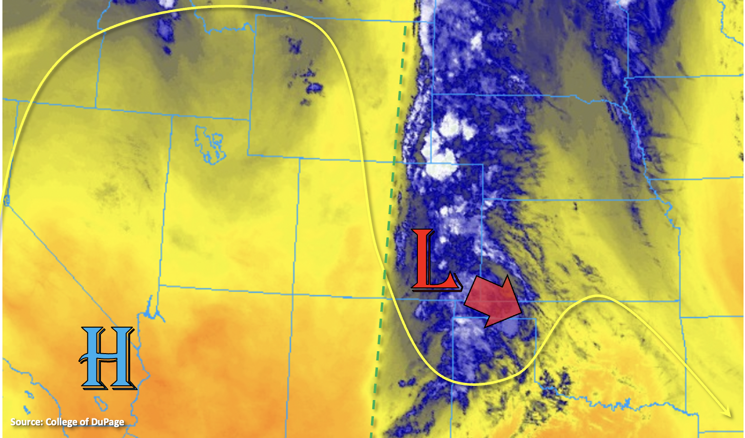
There are two quite distinct air masses shown in the water vapor imagery below. To the west of the green dashed line, drier air (yellow shades) has begun to fill in behind the trough with increasing northwesterly flow. PW at Grand Junction has dropped to 0.77 inches, and it is expected to continue to drop at least another tenth throughout the day. Whereas to the east of the green dashed line, the monsoon moisture plume is keeping dew points and PW well above average. PW at Denver this morning was measured at 1.15 inches, and with extra lift from the vorticity maximum, moderate rainfall is already occurring over the central plains.
So as far as rainfall chances, to the west of the Continental Divide, storms may again be possible this afternoon and evening with the residual moisture in the area (indicated by morning fog in the mountain valleys). However, storms that develop with the diurnal flow should be high-based and isolated in nature, which will reduce the flood threat and produce more cloud cover than measurable rainfall. To the east, the slow-moving vorticity maximum will continue to enhance mid-level lift in a moisture-rich environment. So as the day goes on, and a bit more heating occurs, expect storm coverage and intensity to expand across the plains. Longer duration rainfall (2 to 6 hours) may allow for some higher end rainfall accumulations that could cause flooding issues. Moreover, some stronger thunderstorms may develop over the Southeast Plains (south) where a bit more instability could build. While nearly fully-grown crops may help to mitigate the flooding issues, isolated totals just over 3 inches are possible and could still cause some road flooding, field ponding and local creek/arroyo flooding. For these reasons, a LOW flood threat has been issued.
Lastly, an additional set of more vigorous thunderstorms may be possible over the Southeast Mountains and elevated ridges where clearing has already begun. With steering flows from the northwest, some of these storms may spill into the immediate adjacent plains. Slightly faster steering flows should somewhat mitigate the flood threat, but the high moisture content will allow for heavy rainfall in the storm cores, and training storms could increase local accumulations. The LOW flood threat has been extended back to the west for this reason. Should the flood threat become more elevated over this region by this afternoon, a PM update will be issued.
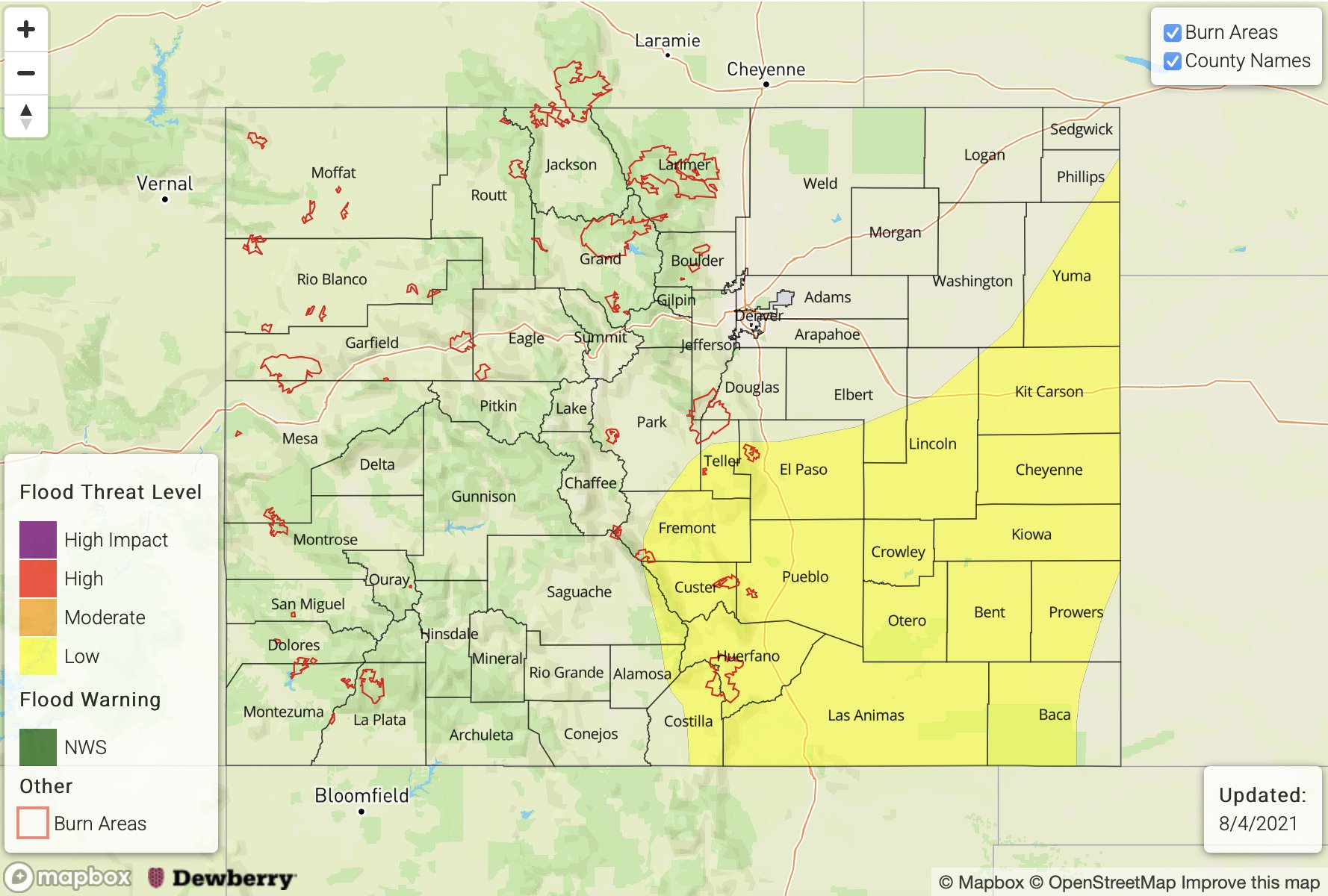
Today’s Flood Threat Map
For more information on today’s flood threat, see the map below. If there is a threat, hover over the threat areas for more details, and click on burn areas to learn more about them. For Zone-Specific forecasts, scroll below the threat map.
Zone-Specific Forecasts:
Front Range, Northeast Plains, Urban Corridor, Southeast Mountains, Raton Ridge, Palmer Ridge & Southeast Plains:
A quieter day is ahead over the northern portions of these regions behind the trough. Ongoing storms will expand in coverage and strength south and east. Max 1-hour rain rates up to 1.75 inches (east) & 1.50 inches (west) with totals up to 3 inches (east) and 2 inches (west) will be possible. This may cause local flooding issues with flood threats including debris flows (mountains), local creek/arroyo flooding, field ponding and road flooding.
Primetime: Ongoing to 10PM
Grand Valley, San Luis Valley, Northern Mountains, Northwest Slope, Southwest Slope, Central Mountains & San Juan Mountains:
A much drier day is ahead with the drier air working in from the northwest. Isolated storms will still be possible with residual moisture, but high storm bases should limit the flood threat. Storms may produce some brief outflow winds and cloud cover is more likely than measurable rainfall. Isolated max 1-hour rain rates up to 0.50 inches will be possible near and along the divide (south) with isolated accumulations under 0.10 inch elsewhere. Flooding is NOT forecast.
Primetime: 1PM to 8PM