Issue Date: Sunday, July 25th, 2021
Issue Time: 10:10AM MDT
— A MODERATE flood threat has been issued for the Grand Valley, Southwest Slope, San Juan Mountains, Central Mountains, Front Range, Southeast Mountains and Raton Ridge
— A LOW flood threat has been issued for portions of the Northwest Slope, Northern Mountains, Urban Corridor, Palmer Ridge, Northeast Plains and Southeast Plains
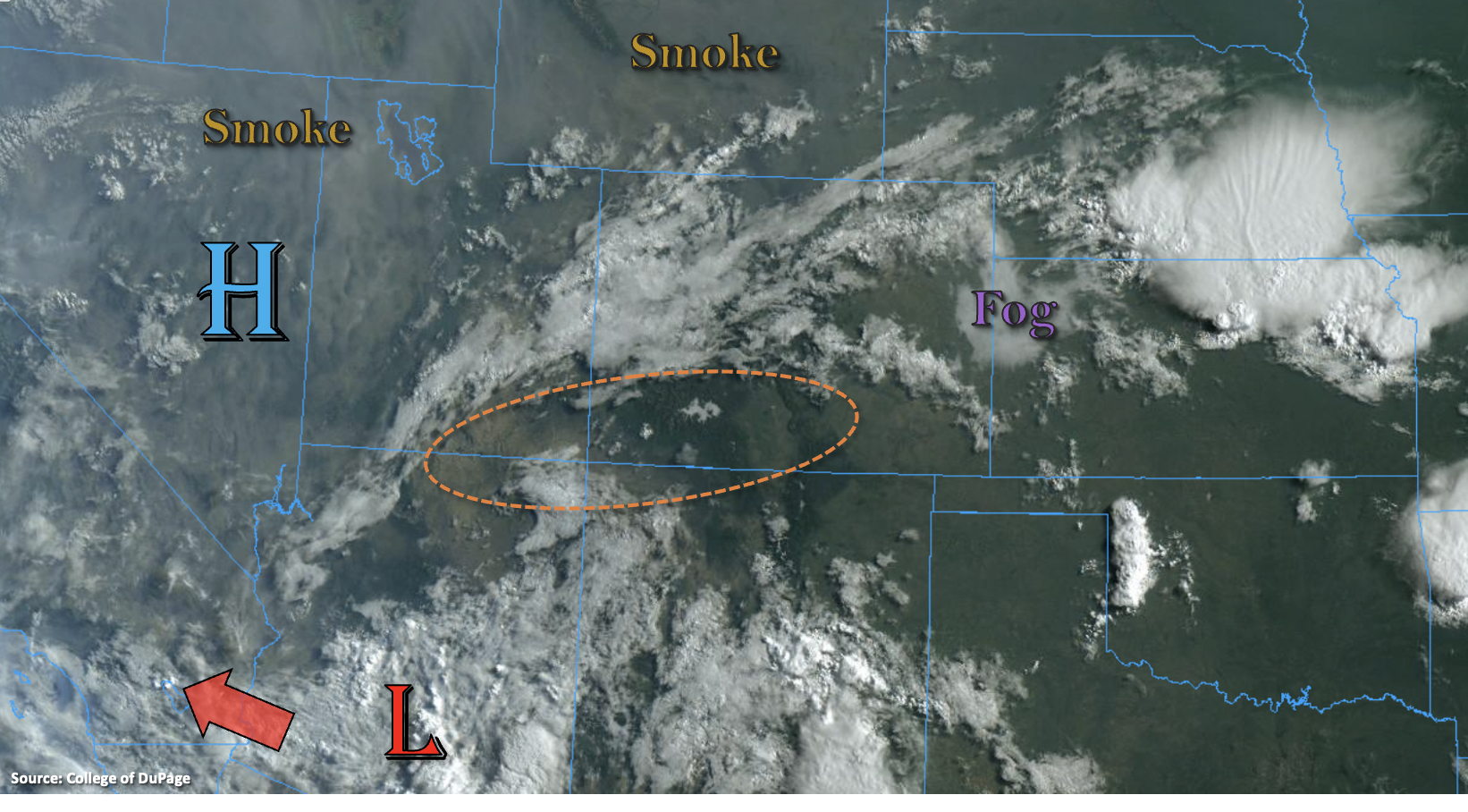
The busy rainfall season continues. Visible satellite imagery below shows cloud cover over the northern portion of the state associated with the ongoing monsoon moisture surge, which is helping to generate some isolated, light showers over the western border this morning. There is also a noticeable drier air mass over the southwest corner as indicated by the lack of cloud cover (orange dotted oval). This may help to reduce the storms coverage over this region today. Not much change in the overall pattern, but the area of Low pressure from yesterday should have less of an influence on the overall pattern as it continues its westward progression. With the High pushing slightly north, due to the movement of the Low, steering flow over the state will really be lacking today. What that means is that storms will likely be anchored to the high terrains, remain nearly stationary, and pulse in intensity. So, while less coverage of the heavy rainfall is anticipated, storm cores will still be able to drop a lot of rain over an area.
PW at Grand Junction was measured at 1.08 inches, so storms over the western elevated terrains will again have the potential to produce around an inch of rainfall over a short duration. Cloud cover also seems to be clearing out fairly easily with the daytime heating, which will let instability build for stronger storm cores. Over the eastern mountains, the heavy rainfall threat also continues with PW increasing towards the southern border. Numerous rounds of rainfall over the last 5 days across the mountains will support soils producing excessive runoff as well as mud flows and debris slides. For these reasons, the MODERATE/LOW flood threat continues.
There are also flooding concerns over the eastern plains where a dryline sets up with a lee trough. There is a high likelihood of storms popping along the northern portion of it by mid-afternoon. With PW over 1.50 inches, dew points in the 60Fs and slow steering flows, storms that develop have the potential to produce VERY heavy rainfall. Outflow boundaries may aid in triggering additional convection over the denoted LOW flood threat area. Flooding concerns include local stream/creek flooding, arroyo flooding, road flooding and heavy field ponding.
Today’s Flood Threat Map
For more information on today’s flood threat, see the map below. If there is a threat, hover over the threat areas for more details, and click on burn areas to learn more about them. For Zone-Specific forecasts, scroll below the threat map.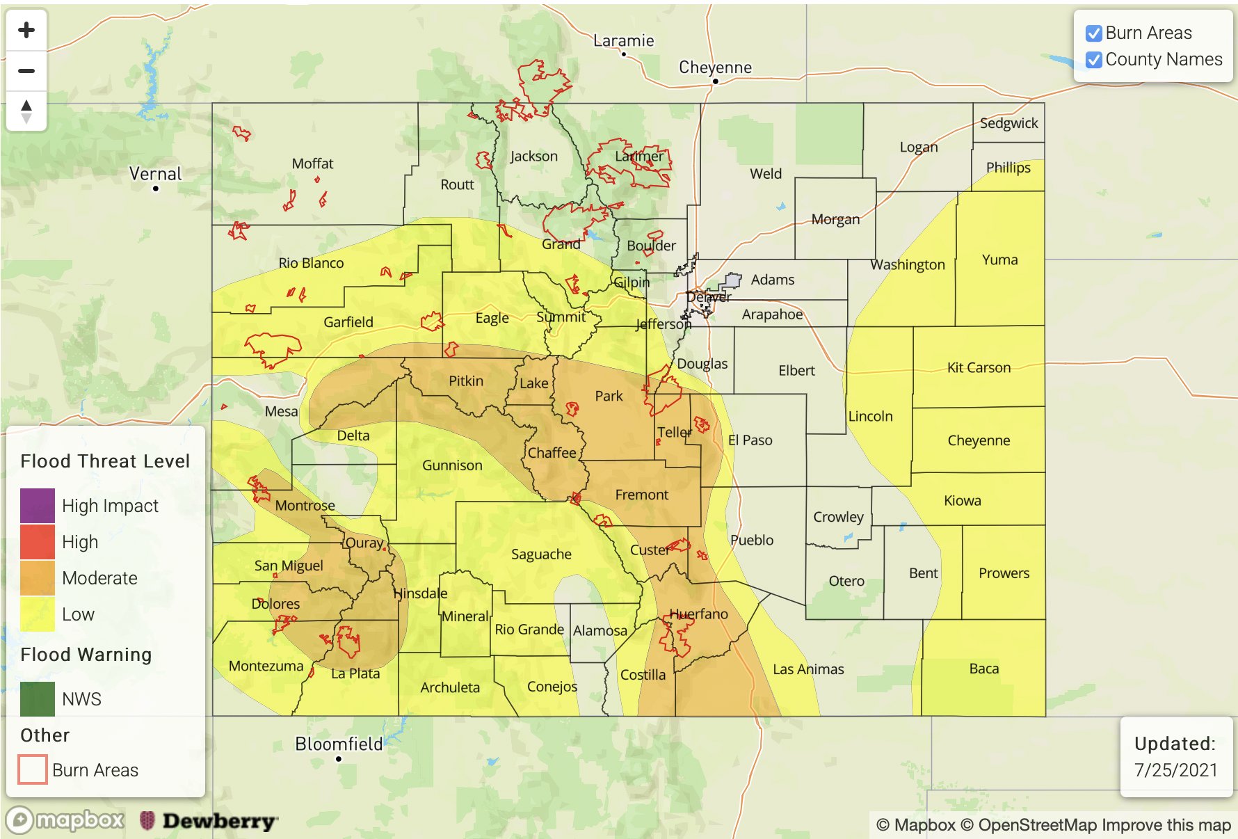
Zone-Specific Forecasts:
Front Range, Northern Mountains, Northwest Slope, Grand Valley, Central Mountains, Southeast Mountains, Southwest Slope, Raton Ridge, San Luis Valley & San Juan Mountains:
Heavy rainfall is likely again by early this afternoon over the high terrains. While heavy rainfall is likely to be less widespread, nearly stationary storms will help to increase local precipitation totals. Over western Colorado, max 1-hour rainfall rates up to 1.75 inches (central), 1.50 inches (south) and 1 inch (north) will be possible. Isolated storm totals up to 3.25 inches will be possible and most likely within the central portions of the mountains.
To the east, max 1-hour rain rates up to 1.75 inches will be possible along with storm totals up to 3.25 inches. Less coverage of rainfall is anticipated over the northern Front Range, but rain rates up to 0.50 inches will be possible with the more isolated storms that do develop.
A MODERATE/LOW flood threat have been reissued. Saturated soils will again increase the flood threat today as excessive runoff and mud flows/debris slides become more likely. Other threats include road flooding and local stream/creek flooding. Most of the storms should come to an end around 11PM with lighter rainfall activity into the morning early hours.
Primetime: 11AM to 2AM
Palmer Ridge, Urban Corridor, Northeast Plains & Southeast Plains:
A dryline sets up over the Northeast Plains, and some storms will likely pop along it by mid-afternoon. Due to the high moisture environment and slow-moving nature of the storms, VERY heavy rainfall is possible with max 1-hour rain rates up to 3.5 inches. Additional storms may develop further south with outflow boundaries through tonight. Storm totals up to 4 inches may be possible, which could cause local creek/stream flooding, road flooding, arroyo flooding and field ponding. In addition to heavy rainfall, the convection may produce damaging outflow winds and some hail. A LOW flood threat has been issued.
Primetime: 3PM to 11PM