Issue Date: 8/4/2015
Issue Time: 10:05AM
— Flooding is NOT expected today.
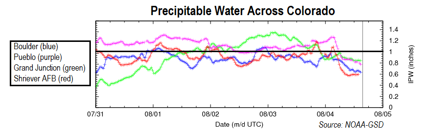
After a very busy weather day yesterday, Colorado now sits in the wake of yesterday’s disturbance. The net result is two-fold: first, substantial drying of the atmospheric column statewide, and second, general subsidence as is typical after a disturbance passage. The time series of precipitable water (PW) values, shown below, illustrates just how much drying has occurred in the last 24 hours. For example, yesterday morning, Grand Junction had a PW of 1.35 inches, but today it is only 0.8 and falling.
 For today, we expect a mostly sunny and seasonally hot day across the state. Gusty winds have been observed in the higher elevations (especially north of I-70) this morning and these may continue through mid-afternoon before the pressure gradient eases. An isolated afternoon thunderstorm cannot be completely ruled out in the Northeast Plains but rainfall amounts will stay below 0.5 inches.
Today’s Flood Threat Map
For more information on today’s flood threat, see the map below (hover over threat areas for more details). For Zone-Specific forecasts, jump below the map.

Zone Specific Forecasts
Northwest Slope, Northern Mountains, Central Mountains, Grand Valley, San Juans, San Luis Valley, Southwest Slope:
Mostly sunny to partly cloudy skies and seasonally hot today with highs between 90-95F in the lowest elevations and 60s in the highest elevations. Gusty winds, up to 50 mph will be possible through mid-afternoon above 10,000 feet. Winds should subside by early evening as the disturbance causing the strong pressure gradient moves eastward. Flooding is not expected today.
Northeast Plains, Front Range, Urban Corridor, Palmer Ridge, Southeast Plains, Southeast Mountains, Raton Ridge:
Mostly sunny with a few spotty clouds and seasonably hot today with high temperatures in the low to mid 90s in the lowest elevations of the Arkansas River valley to the 60s in the highest terrain of the Front Range. Gusty winds, up to 65 mph, will be likely over the highest terrain of the Front Range through mid-afternoon. A stray shower or weak thunderstorm may graze the far northeast corner of the Northeast Plains but rain rates will be below 0.5 inches. Thus, flooding is not expected today.