Issue Date: Saturday, July 24th, 2021
Issue Time: 10:30AM MDT
— A MODERATE flood threat has been issued for the Southwest Slope, San Juan Mountains, Central Mountains and Front Range
— A LOW flood threat has been issued for portions of the Southeast Plains, Northwest Plains, Urban Corridor and Palmer Ridge, as well as the higher terrains of the Southeast Mountains, Northern Mountains, Grand Valley, Raton Ridge and Northwest Slope
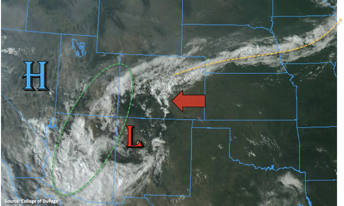
The satellite imagery below shows a lot of cloud cover over the northern portion of the state behind a cold front that came through. Accompanying this cloud cover is a slightly drier air mass, and PW over Denver has dropped to 0.96 inches this morning. Between these two factors, rainfall chances will be lower today north of I-70. Best chance for storms to develop over this region will be where the sun can break through and build some instability, so likely over the Flat Top region. Thus, the Low flood threat has been extended northwards into this area. Overall, there is a much lower threat for downpours over this area when compared to yesterday; however, if storms can develop, anticipate some local, heavy rainfall.
The main focus for the heavy rainfall potential today is across southern Colorado. With the Low just south of the border near the Four Corners area, steering flows will be from the east today. That means that more rainfall should be expected over the Southwest Slopes as storms move off the higher elevations. PW at Grand Junction and Albuquerque continues to be over an inch, which is still well above normal for this time of year. That means that storms should again be efficient rainfall producers with the moist surface layer, and local rainfall totals up to 3 inches will be possible in the Moderate threat areas drawn below. With saturated soils from the last 24 to 96-hours of precipitation (see SPM), an increase in runoff is likely, which could cause some flooding of local streams. Soils will likely also be less stable with all of the rainfall, which could lead to more mud flows and debris slides where the heavy downpours develop. Thus, a MODERATE/LOW flood threat has been issued.
In addition to another day of monsoon rainfall across the mountains, there is a possibility of some thunderstorms capable of producing heavy rainfall along the orange dotted boundary shown below. This front is forecast to drop south throughout the day, where it may encounter some stronger instability and high moisture. In similar fashion to yesterday, storms that develop on it will likely be nearly stationary and the extra convergence along the boundary could produce high rainfall totals. The Low flood threat has been extended eastward.
 \
\
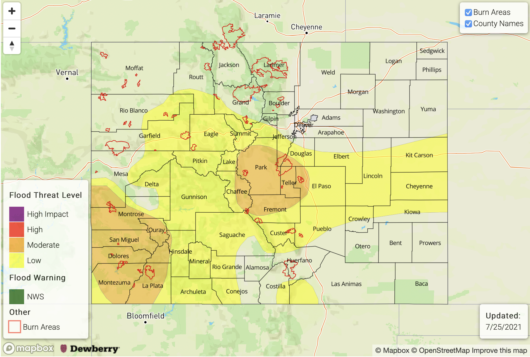
Today’s Flood Threat Map
For more information on today’s flood threat, see the map below. If there is a threat, hover over the threat areas for more details, and click on burn areas to learn more about them. For Zone-Specific forecasts, scroll below the threat map.
Zone-Specific Forecasts:
Front Range, Central Mountains, Southeast Mountains, Southwest Slope, Raton Ridge, San Luis Valley & San Juan Mountains:
Another round of monsoon moisture fueled storms are forecast today with the steering flow changing to more easterly. Max 1-hour rain rates up to 1.75 inches will be possible along with isolated storm totals up to 3 inches. This will most likely occur in the MODERATE flood threat areas drawn above. This could cause road flooding, local stream flooding and mud flows/debris slides over the steeper terrains. This is especially true over areas with saturated soils, so use extra caution around these areas. The flood threat should come to an end a couple hours after sunset, though some rainfall may linger into the early morning hours over the San Juan Mountains. The interior of the San Luis Valley could see isolated totals up to 0.50 inches once again.
Primetime: 11AM to 2AM
Urban Corridor, Palmer Ridge, Northeast Plains & Southeast Plains:
Some low-end severe thunderstorms will likely develop along the cold front as it drops southwards today. This could produce local heavy rainfall this afternoon and evening along with some small hail and damaging outflow winds. Max 1-hour rain rates up to 1.50 inches and local storm totals up to 3 inches would be possible. Storms will likely linger into the early morning hours, but the flood threat should come to an end a couple hours after sundown.
Primetime: 2PM to Midnight
Northern Mountains, Northwest Slope and Grand Valley:
Without much instability being able to form with the ongoing cloud cover, rainfall chances are much lower over this area today. If some sun is able to break through (most likely west), some heavy rainfall producing storms would be likely. Max 1-hour rain rates up to 1 inch (west) and 0.75 inches (east) would be possible. Some light showers will be possible over the Northwest Slope this evening, but flooding is NOT forecast. For the most part, it should be a cooler day with high temperatures reaching into the upper 70Fs to low 80Fs for the mountain valleys and upper 80Fs to low 90Fs for the Northwest Slope.
Primetime: 3PM to 11PM