Issue Date: Friday, July 23rd, 2021
Issue Time: 10:05AM MDT
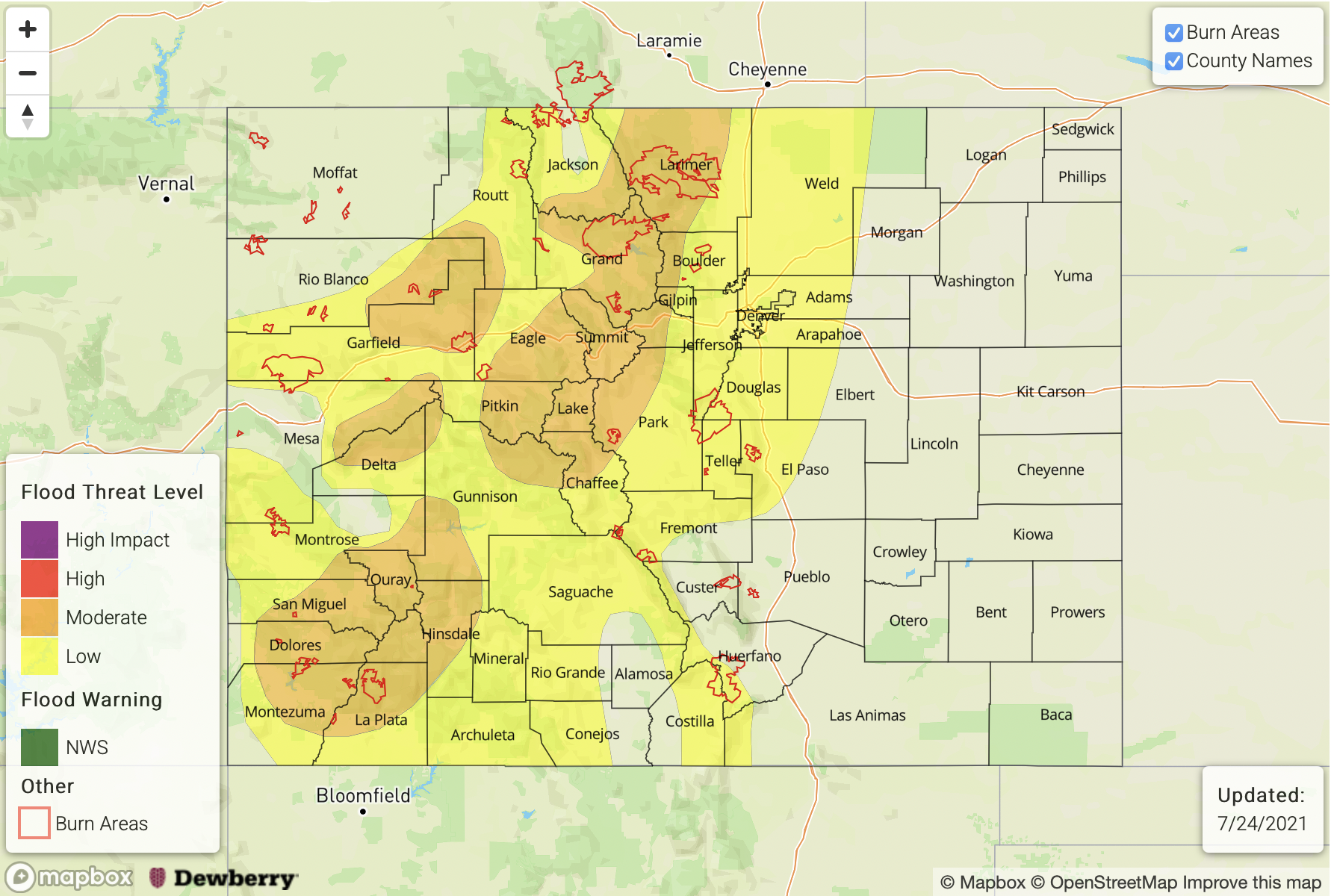
— A MODERATE flood threat has been issued for the San Juan Mountains, Central Mountains, Grand Valley, Northwest Slope, Southwest Slope and Front Range
— A LOW flood threat has been issued for Southeast Mountains, Palmer Ridge and Urban Corridor
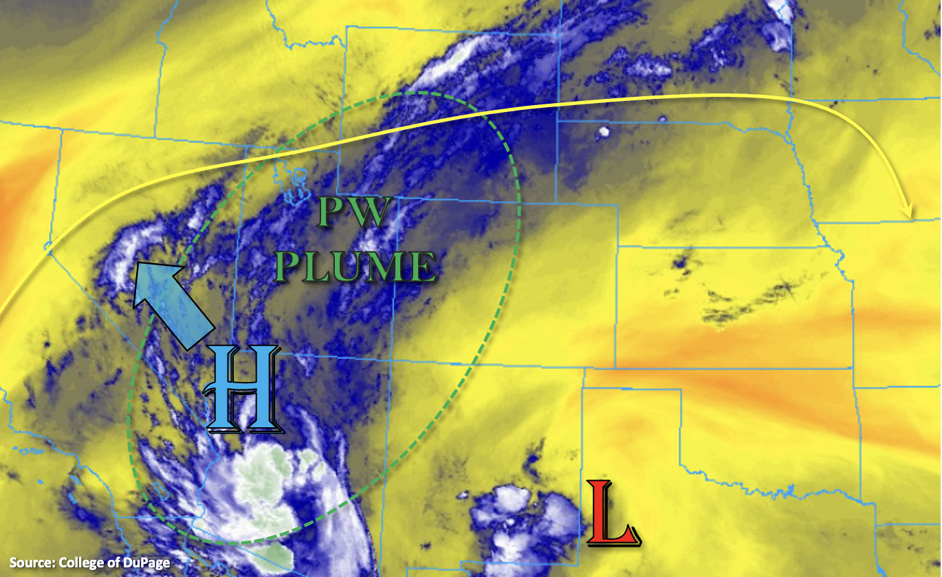
Not much change in the overall pattern this morning with the High continuing to pull above average moisture northward. This is helping to create some cloud cover over the western border and Northern Mountains this morning, which may be producing some light precipitation as well. Throughout the day, the High will begin to be displaced to the northwest as a Low traverses westward from Texas. This will produce more easterly steering flows south and more westerly steering flows north for the storms that develop today.
PW at Grand Junction was measured at whopping 1.27 inches, which is about the highest the maximum moving average gets during monsoon season. At Denver, PW was measured at 1.14 inches, which is still equally impressive. Both soundings indicated high moisture from the surface to the upper layers, which means storms that develop today will be very efficient rainfall producers once again. The upper-level pattern will help storms remain more stationary in nature and pulse-like in intensity once again. Highest coverage of rainfall west should be over the south/central high terrains, and to the east rainfall should favor the Front Range and Palmer Ridge with more limited coverage over the Southeast Mountains. Some additional storms are also possible over the Urban Corridor and Northeast Plains this evening.
Saturate soils are a concern over the mountains today as they can lead to excessive runoff and an increased threat for mud flows/debris slides if a storm moves overhead (unstable ground). In addition to this threat, storms are expected to produce intense rain rates again with decent instability forming over the Front Range and portions of the San Juan Mountains for convection. For the reasons stated above, another MODERATE flood threat has been issued. Scroll down for more details about the flood threat over your region.
Today’s Flood Threat Map
For more information on today’s flood threat, see the map below. If there is a threat, hover over the threat areas for more details, and click on burn areas to learn more about them. For Zone-Specific forecasts, scroll below the threat map.
Zone-Specific Forecasts:
Northern Mountains, Front Range, Central Mountains, Southeast Mountains, Grand Valley, Northwest Slope, Southwest Slope, San Luis Valley & San Juan Mountains:
Widespread, heavy rainfall producing storms are forecast again this afternoon and evening, so the MODERATE/LOW flood threat continues. Max 1-hour rain rates up to 2.25 inches with local totals up to 3.50 inches will be possible by morning in the MODERATE threat areas. Best chance for the higher accumulations will be over the San Juan Mountains or near the Continental Divide (central/north). The interior of the San Luis Valley may see up to 0.40 inches of rainfall. Flash flooding of local streams, mud flows and debris slides will be possible with the stronger storms that develop and over areas with saturated soils (mountains). This includes recent burn areas, so please head over to the FBF for the elevated threats issued for today. Most rainfall should end just after midnight, but light showers may linger over the high terrains through early tomorrow morning.
Primetime: 12:30PM to 4AM
Urban Corridor, Palmer Ridge, Raton Ridge, Northeast Plains & Southeast Plains:
Isolated storms will likely develop over the Palmer Ridge early this evening, and additional storms are possible north (westerly steering flow) with better coverage of rainfall overall compared to yesterday. Max 1-hour rain rates up to 2 inches (north) and 1.75 inches (south) may be possible, which could cause flooding of local streams, roads and low-lying areas. A LOW flood threat has been issued. The flood threat should end later this evening, but some rainfall may linger over the northern Urban Corridor/northern Northeast Plains overnight.
Primetime: 2PM to 1AM