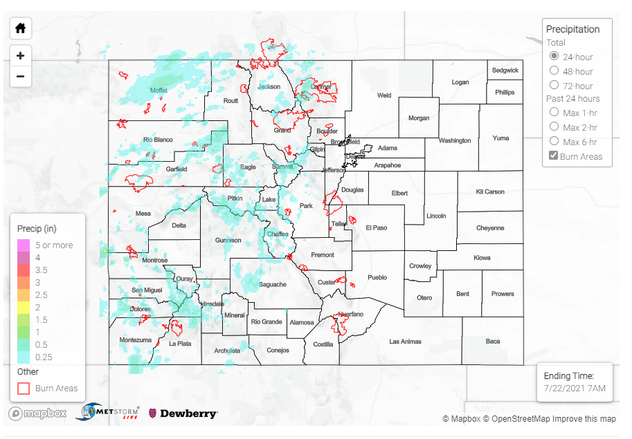
Issue Date: Wednesday, July 21, 2021
Issue Time: 9:50 AM MDT
Summary:
Yesterday saw two very different setups between the eastern and western halves of the state, with the Continental Divide acting as a barrier between the plume of monsoonal moisture advecting into the state. There was widespread thunderstorm activity in the west, compared to hot and dry conditions to the east. The extra monsoonal moisture that flowed into Northern and Central Mountains helped to moderate fire behavior on the Morgan Creek, Sylvan, and Muddy Slide fires with higher humidity and chances for wetting rains from thunderstorms. However, heavy rains also resulted in floods in the Poudre Canyon, Glenwood Canyon, and near Telluride.
Flash flood warnings were issued for the Poudre Canyon after Doppler radar indicated heavy rainfall, and the canyon was evacuated yesterday evening. Up to 1 inch of rain fell in just half an hour over the Cameron Peak burn scar, resulting in rapid, deadly debris flow and runoff into the Cachle la Poudre River. Kylie Bearse shared the following video on twitter showing the fast-moving river – debris and ash from the burn scar cause the river to look black. Highway 14 remains closed from Rustic to Cameron Pass.
Nearly an inch of rain in 30 minutes last night caused this flash flood in the Poudre Canyon – Another Flash Flood Watch in effect for the area today #cowx Video from Wayne Couch #cowx pic.twitter.com/TbuhwzLBuF
— Kylie Bearse (@KylieBearseWX) July 21, 2021
Widespread storms lingered in the Central Mountains late into the night. A flash flood warning for Glenwood Canyon was issued at 8:36 pm after Doppler radar indicated heavy rainfall over the Grizzly Creek burn scar, prompting a safety closure of I-70 through the canyon. Several debris flows ultimately made their way down the canyon, blocking the westbound lanes of I-70 and requiring cleanup – the interstate is still closed this morning. A CoCoRaHS observer in Glenwood Springs reported up to 0.40 inches of rain yesterday.
Heavy rains also produced flooding and debris flows in Telluride. A sheriff reported a tree and mud over Highway 145, and an additional debris flow crossing the road near Bridal Veil Falls. A CoCoRaHS observer in Placerville, west of Telluride, reported 0.72 inches yesterday and the following remark:
Rain began at 2:30 pm with .4 inch between then and 2:45. Another cloudburst around 4pm then rain and drizzle till 10pm.
For rainfall estimates in your area, check out the State Precipitation Map below.
Click Here For Map Overview
Note: The 24-hour, 48-hour and 72-hour total precipitation do not contain bias corrections today due to errors in the CoCoRaHS data. This means there may be underestimations in QPE over the southwest and southeast corners of the state.
