Issue Date: Saturday, July 17, 2021
Issue Time: 9:50 AM MDT
Summary:
Friday afternoon began with light rain across the Southwest Slope, San Juan Mountains, Northern Mountains, Central Mountains, and Palmer Divide, fueled by monsoonal moisture which produced isolated to scattered storms. Rainfall totals in these areas were light, ranging from Trace – 0.25 inches, and up to 0.35 inches reported north of Durango in the Southwest Slope.
However, the real story of the day was severe storms and very heavy rain on the Eastern Plains. As general storm motion moved eastward off the high elevations and on to the plains, storms tapped into additional moisture and elevated instability. Storms were also very slow-moving, which combined to create high rainfall totals.
At 7:15 pm, heavy rain was reported in Bethune by a trained spotter – 1.70 inches over an approximately 3-hour period. That rainfall rate (1.70”/3-hours) in this region is between a 2-year and 5-year Average Recurrence Interval (ARI; or 50%-20% chance of occurrence in any given year). Just east of Bethune along I-70, 1.40 inches of rain was reported in Burlington, along with flash floods:
1.4 INCHES OF STORM TOTAL RAIN WAS REPORTED IN THE OWNERS RAIN GAUGE. REPORTED VIA SOCIAL MEDIA WITH PHOTO. HEAVY RAIN PRODUCED ENOUGH RAIN FOR WATER TO REACH THE RUNNING BOARDS ON A JEEP. ESTIMATED 4-6 INCHES. -Public Report
1.41 was also reported by a CoCoRaHS observer in Burlington, verifying the high rainfall total reported by the public. Flash flood warnings and severe thunderstorm warnings were also issued, with the largest threats aside from heavy rain being high winds and large hail. Over 50 mph wind gusts were reported along with pea to dime sized hail.
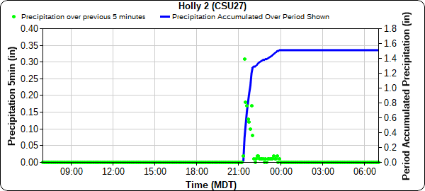
Further south, another 1.70 inches was reported by a CoCoRaHS observer in Holly. A nearby CoAgMet Station reported 1.51 inches, again with nearly all of the precipitation falling in a 3-hour period (see time series plot below). 1.70 inches in 3-hours in Hollyalso amounts to just over a 2-year rainfall event, or 50% chance of occurring in any given year based on Precipitation Frequency Estimates from NOAA Atlas 14. The fairly low ARIs shows that while the rainfall totals are high, they are not particularly rare events for this part of the state. Other notable rainfall totals from CoCoRaHS observers:
- 1.42 in Arapahoe (Cheyenne County)
- 1.37 in Arriba (Northern Lincoln County)
- 1.20 in Haswell (Southern Lincoln County)
For rainfall estimates in your area, check out the State Precipitation Map below.
Click Here For Map Overview
