Issue Date: Saturday, July 17th, 2021
Issue Time: 9:40AM MDT
— A LOW flood threat has been posted for parts of the Northeast Plains, Palmer Ridge, Southeast Mountains, Raton Ridge, Southeast Plains and San Juan Mountains
— Over the Northeast Plains, the threat persists into the early overnight hours
Mostly clear skies greeted most of Colorado this morning as a ridge of high pressure aloft has begun to build along the NM border. A couple of weak disturbances were noted on satellite and water vapor imagery, one over the Northwest Slope and a second along the southern KS border in association with a dissipating complex of overnight storms. However, most of today’s rainfall activity will be generated by high elevation heating, a staple of Colorado summer. In terms of changes over the past 24-hours, the ridge has strengthened slightly and will continue to do so throughout the day. This will bump up high temperatures by 3-5F over most of the state. Ironically, the strengthening ridge will likely increase chances of heavy rainfall over the higher terrain as subsidence will tend to dissipate weaker updrafts, leading to fewer cells overall but with higher potential rain rates over cells that do stay intact. Near-surface and total column moisture has increased statewide with radiosonde PW at 0.91 inches in Grand Junction and 0.80 inches at Denver; morning model initializations showed up to 1.4 inches along the OK border. Dewpoint temperatures are generally 1-3F higher compared to yesterday morning. Some drying was noted along and west of the UT border, which will make it into the northern and central parts of the Western Slope, reducing storm coverage a bit. Weak, generally westerly steering flow of 15mph is expected over most of the state, transitioning to more northerly over eastern Colorado especially this evening as the ridge extends northward.
In terms of sensible weather, we expect scattered to numerous thunderstorms over the climatologically preferred higher terrain of the Palmer Ridge, Southeast Mountains and San Juan Mountains this afternoon. A Low flood threat is warranted for these regions as max instability in the 700-1,100 J/kg range along with light steering flow will support the chance of 30-60 minute periods of heavy rainfall mainly this afternoon and early evening. Meanwhile, as storms move off the Cheyenne Ridge along the WY border, guidance suggests they will encounter upslope moist flow, aided by a nocturnal low level jet, which will support a ~3 hour of period of heavy rainfall late this afternoon and into the early overnight hours. Enough shear will be present to also sustain the threat of severe weather of the large hail and damaging wind variety. Outflow boundaries from this possible complex could trigger some more isolated storm activity along the Palmer Ridge into the overnight hours.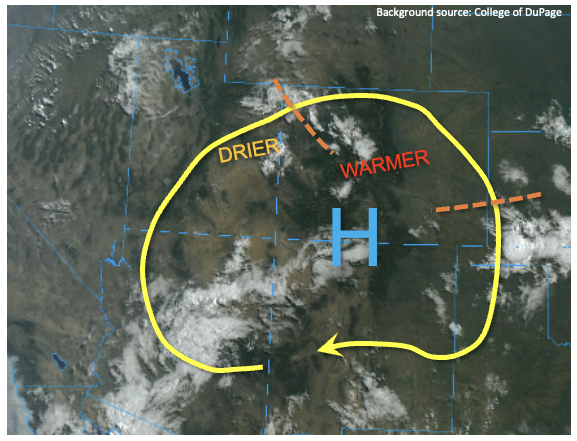
Today’s Flood Threat Map
For more information on today’s flood threat, see the map below. If there is a threat, hover over the threat areas for more details, and click on burn areas to learn more about them. For Zone-Specific forecasts, scroll below the threat map.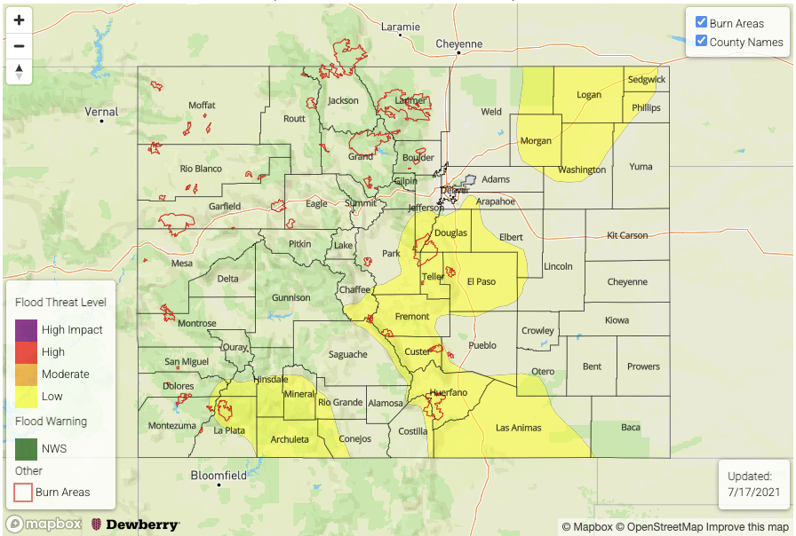
Zone-Specific Forecasts:
Northeast Plains:
Warmer with scattered showers and thunderstorms possible, beginning late afternoon and last into the early overnight hours. Max 1-hour rainfall up to 2.5 inches and max 3-hour rainfall up to 3.7 inches warrants a Low flood threat for isolated flash flooding. Large hail and damaging winds could accompany the strongest cells.
Primetime: 4PM through 2AM
Raton Ridge, Palmer Ridge, Southeast Plains, Southeast Mountains, Central Mountains, Northern Mountains, Front Range and San Juan Mountains:
Warmer with scattered to numerous showers and thunderstorms this afternoon and evening, especially over the higher terrain. Max 1-hour rainfall up to 1.5 inches (east) and 1.1 inches (west) warrants a Low flood threat for isolated flash flooding, debris slides and mud flows. A couple of storms could persist into the late evening over the Palmer Ridge.
Primetime: 12PM through 10PM
Grand Valley, Northwest Slope, Southwest Slope, San Luis Valley and Urban Corridor:
Warmer with isolated to widely scattered thunderstorms possible this afternoon and evening. Max 1-hour rainfall up to 0.8 inches (east) and 0.5 inches (west). Flooding is NOT expected today.
Primetime: 12PM to 9PM