Issue Date: Friday, July 16th, 2021
Issue Time: 10:10AM MDT
— A LOW flood threat has been issued for the Northeast Plains and Southeast Plains
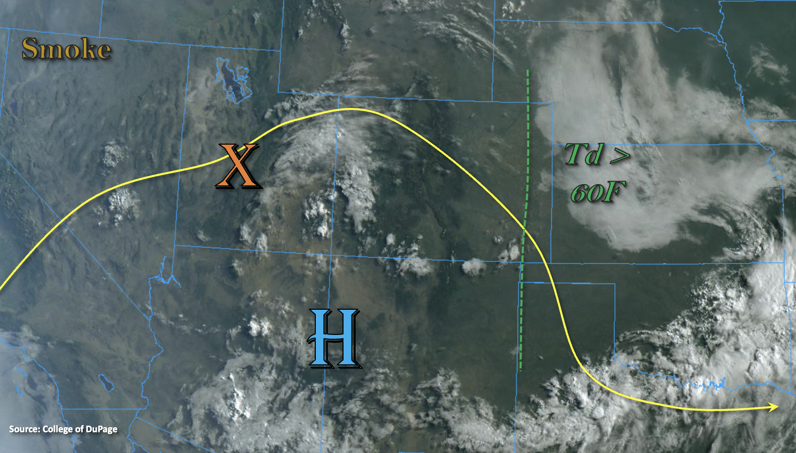
Over the eastern plains this morning dew points are 60F+, which is helping to produce fog with the cool morning temperatures. This should begin to burn off with a little more heating. As for the large-scale pattern today, the ridge will continue to build over the state, which should increase afternoon high temperatures another few degrees. A shortwave is forecast to move around the High (orange “X”), and it is already generating some cloud cover with a plume of moisture out in front of it. PW at Grand Junction was measured at 0.75 inches with a large majority of the moisture aloft. Higher PW values and surface moisture are located across the southern border again. This should set the stage for another round of storms and showers over the western high terrains favoring the San Juan Mountains for better storm coverage and moderate rainfall accumulation.
As this area of lift moves east, it will also help to generate some high-based showers over the eastern mountains. Steering flows from the WNW are expected to push the scattered storms into the adjacent plains by early afternoon. Initially, the storms are expected to be high-based and produce only moderate rainfall, but as they move into deeper moisture over the far eastern plains, the storms should begin to intensify. A couple severe storms capable of producing hail and strong outflow winds will be possible. With slightly weaker northerly steering flows forecast by this evening, storms over this region may be capable of producing local flooding issues. A Low flood threat has been issued with the flood threats including road/local creek flooding and field ponding.
Today’s Flood Threat Map
For more information on today’s flood threat, see the map below. If there is a threat, hover over the threat areas for more details, and click on burn areas to learn more about them. For Zone-Specific forecasts, scroll below the threat map.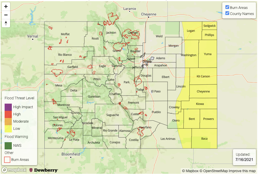
Zone-Specific Forecasts:
Northeast Plains & Southeast Plains:
Storms are expected to arrive over the eastern plains early this evening and may continue overnight with enhanced lift from the low-level jet. Isolated severe storms may develop that could produce large hail and strong outflow winds. Southeasterly surface winds throughout the day will help to keep higher surface moisture over the region, which in turn, will help to intensify the rainfall rates. Winds aloft turns more northerly this evening, which will likely steer some stronger across the northern border and into the Northeast Plains. At this time, storms are forecast to move slower and may do some back-building, which will increase the flood threat. Max 1-hour rainfall rates up to 2 inches and localized storm totals up to 3 inches will be possible. A Low flood threat has been issued for possible road flooding, field ponding and local creek flooding.
Primetime: 5PM to 2AM
Front Range, Southeast Mountains, Palmer Ridge, Raton Ridge & Urban Corridor:
Scattered storms are forecast to develop over the mountains and Palmer Ridge with the next moisture plume arriving to the area. Better storm coverage is forecast south where there’s slightly higher moisture. Max 1-hour rain rates up to 0.40 inches (north) and 0.60 inches (south) are possible over the mountains. Over the adjacent plains, storms are more likely to occur over the Palmer Ridge and south where there’s better southeast surface winds. Max 1-hour rain rates up to 0.90 inches will be possible. Flooding is NOT forecast.
Primetime: 1PM to 11:30PM
Northern Mountains, Grand Valley, Northwest Slope, Southwest Slope, Central Mountains, San Luis Valley & San Juan Mountains:
Storms should pop over the high terrains and elevated plateaus again by early this afternoon. Further north, storms should be more isolated in nature and may produce gusty outflow winds. Max 1-hour rain rates up to 0.30 inches will be possible. Better coverage of storms is anticipated over the San Juan Mountains where there’s slightly higher moisture. Moderate rainfall is forecast with max 1-hour rain rates up to 0.75 inches possible. Places that see training storms over the San Juan Mountains may see storm totals up to 0.90 inches. Flooding is NOT forecast.
Primetime: 1PM to 10:30PM