Issue Date: Thursday, July 15th, 2021
Issue Time: 9:35AM MDT
— Flooding is NOT expected today
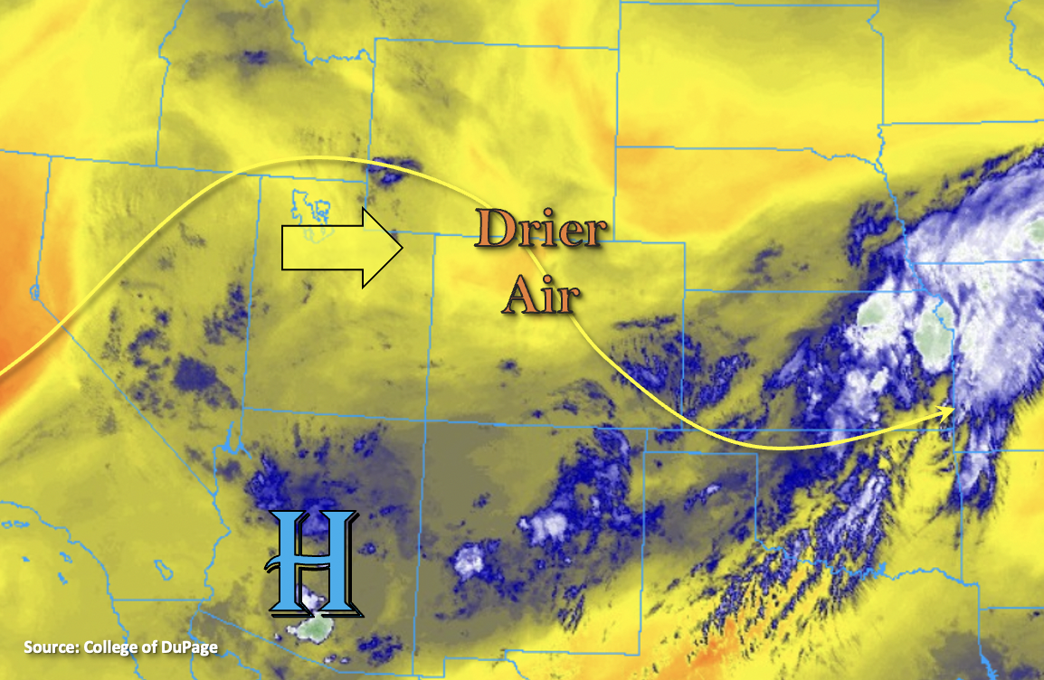
The upper-level ridge has started to build northward again, and the more northerly flow has helped to pull in a drier air mass over the state (north). PW at Grand Junction and Denver has dropped to around 0.80 inches, and there’s a noticeable dry layer in the mid-levels within both soundings. As the ridge moves eastward throughout the day, the rising heights will produce warmer temperatures along with an increase in stability. Between the increase in stability and decrease in available moisture, a downtick in afternoon storm activity and rainfall totals are forecast.
There’s still some lingering moisture that can be seen in the water vapor imager below (blue shades), which is associated with the departing trough. This residual moisture will allow for some high-based, scattered storms to develop with the diurnal cycle over the mountains and elevated ridges. Storm coverage is expected to be greatest over the Central, San Juan Mountains and Front Range. As storms move to the southeast with the northwest steering flow, they are expected to strengthen some over the adjacent plains. The stronger storms that develop may produce some small hail and strong outflow winds. Faster storm movement and less available moisture should only allow for moderate rainfall accumulations, so flooding is not expected today.
Today’s Flood Threat Map
For more information on today’s flood threat, see the map below. If there is a threat, hover over the threat areas for more details, and click on burn areas to learn more about them. For Zone-Specific forecasts, scroll below the threat map.

Zone-Specific Forecasts:
Front Range, Southeast Mountains, Palmer Ridge, Raton Ridge, Urban Corridor, Northeast Plains & Southeast Plains:
Scattered storms will fire over the high terrains this afternoon favoring the Front Range and Palmer Ridge for better coverage. High storms bases and quicker storm movement should allow only moderate rainfall accumulations and plenty of virga. Max 1-hour rain rates up to 0.50 inches will be possible along with brief, gusty outflow winds. As storms move into the adjacent plains, max 1-hour rain rates up to 0.40 inches (west) and 1.40 inches (east) will be possible. Threats for the stronger storms that develop (east) will be small hail and damaging outflow winds. Flooding is NOT forecast.
Primetime: 1:30PM to 11PM
Northern Mountains, Grand Valley, Northwest Slope, Southwest Slope, Central Mountains, San Luis Valley & San Juan Mountains:
Scattered, high-based storms will develop over the mountains by early afternoon. Best storm coverage will be over the Central and San Juan Mountains and elevated ridges of the southern Northwest Slope. Max 1-hour rain rates up to 0.50 inches (west/south) and 0.25 inches (central) will be possible. Storms may produce some brief, gusty outflow winds as well. Flooding is NOT forecast.
Primetime: 1PM to 9PM