Issue Date: 8/3/2015
Issue Time: 10:30AM
— MODERATE flood threat for Central Mountains, Northern Mountains, Raton Ridge and Southeast Plains
— LOW flood threat for Northwest Slope, Grand Valley, Southeast Mountains and Palmer Ridge
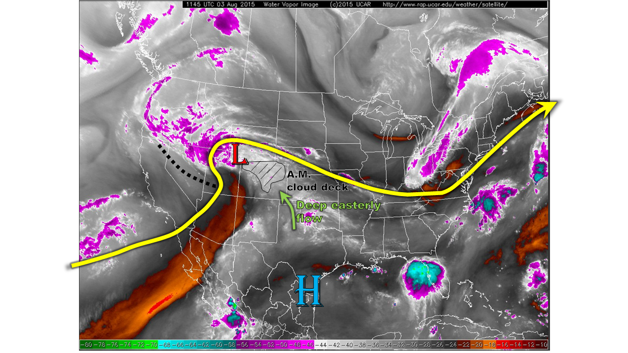
This morning’s weather map is crowded with many players, as shown by the water vapor image below. The most notable feature is the strong disturbance stretching from Colorado west-northwest into Oregon. This was responsible for yesterday’s thundershower activity over our state, and it is slowly moving northeastward today. This feature is also helping to maintain a rather thick cloud deck across central and northern Colorado this morning. It will once again support storm activity across our state today. Meanwhile, in the lower levels, a surface circulation is noted over southwest Wyoming. The main impact of this will be to induce a deep easterly flow east of the Divide through late evening today. It is in fact already doing so: this morning’s atmospheric sounding from Denver has an easterly wind component extending from the surface all the way up through about 17,000 feet. The wind speed in that layer ranges between 17 and 25 knots; these values are noteworthy. Such deep easterly, and thus upslope flow is an important variable in the equation for heavy rainfall in Colorado. Finally, checking this morning’s moisture levels: precipitable water ranged from 0.9 to 1.2 inches. Some subtle drying is seen entering in from the southwest. Surface dewpoint temperatures are very high: mid 50s to mid 60s. Clearly, there is a heavy rainfall threat today. Let’s figure out when and where.
We anticipate two different regions to see a heavy rainfall threat today: in the northwest and in the southeast. In the northwest, proximity to the surface disturbance, combined with precipitable water values near 1 inch will provide necessary ingredients for a Low/Moderate flood threat. In the southeast, instability will be greater, but coverage will be more scattered. Nonetheless, with the advection of precipitable water values as high as 1.6 inches, a Low/Moderate flood threat will be warranted.
Today’s Flood Threat Map
For more information on today’s flood threat, see the map below (hover over threat areas for more details). For Zone-Specific forecasts, jump below the map.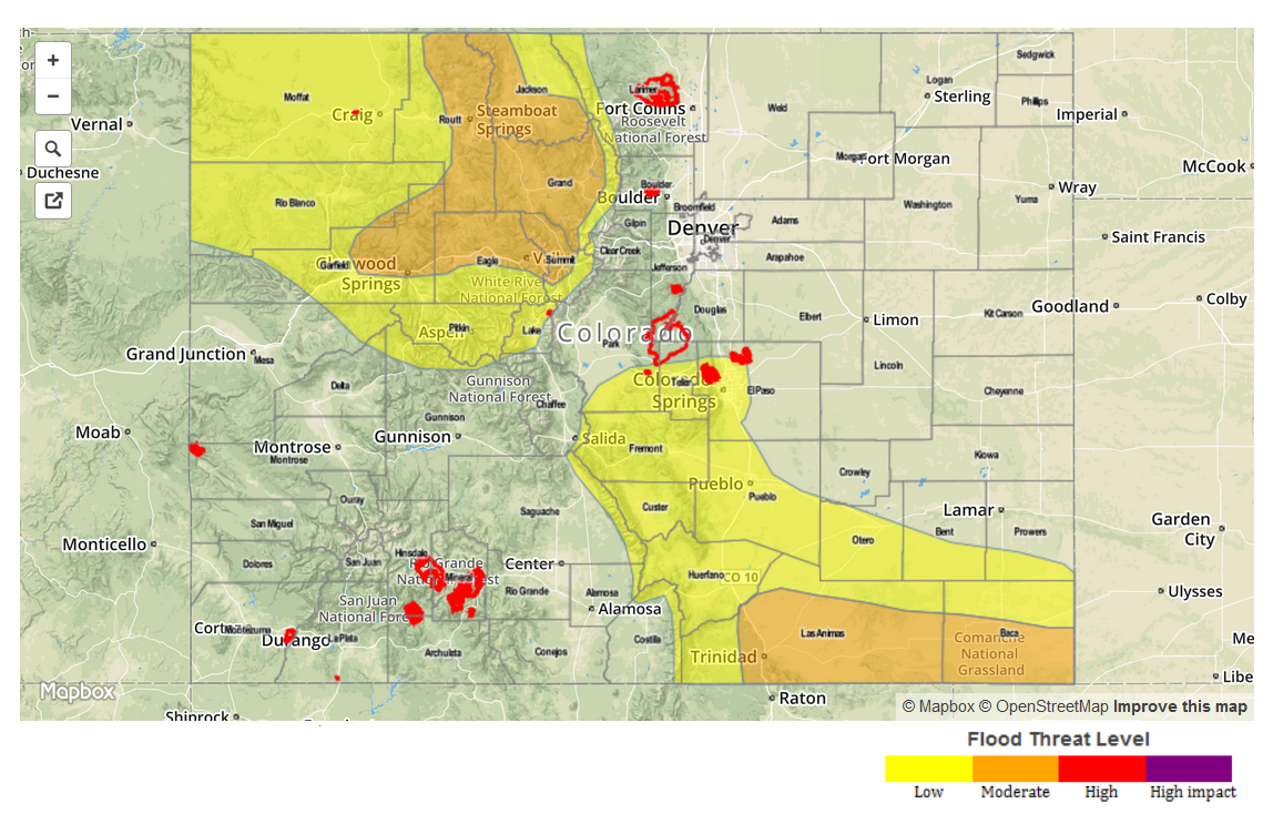
Zone Specific Forecasts
Northwest Slope, Northern Mountains, Central Mountains, Grand Valley:
Mostly cloudy early with scattered showers turning into thunderstorms by early afternoon. Max 1-hr rain rates up to 1.2 inches will be possible. Higher elevation regions, including the Park and Gore Ranges as well as the Flat Tops, could see 3-hr rainfall amounts up to 1.8 inches. A Moderate flood threat is posted for the higher terrain, with a Low flood threat elsewhere. Activity will quickly subside around sunset.
Primetime: 12PM to 8PM
Palmer Ridge, Southeast Mountains, Raton Ridge, Southeast Plains:
Partly cloudy early, with scattered thunderstorms forming by mid afternoon. Max 1-hr rain rates up to 2.4 inches will be possible (highest amounts to the southeast). There is also a good possibility that individual storms will merge into a storm complex. This will add the threat of strong winds, up to 65 mph. Storm activity will generally subside in the late evening, but the flooding threat will exist all the way through 1AM in the far southeast.
Primetime: 2PM to 9PM near the mountains, 3PM to 1AM in the far southeast
Northeast Plains, Front Range, Urban Corridor:
Partly to mostly cloudy with isolated to widely scattered thunderstorms possible in the afternoon. Due to limited instability, maximum 1-hr rain rates are expected to be around 0.7 inches. Thus, no flooding is anticipated. However, stronger storms could provide for gusty winds, up to 50 mph.
Southwest Slope, San Juans, San Luis Valley:
Partly sunny with isolated thunderstorms possible from early afternoon to through sunset. Due to drying behind the disturbance passage, max 1-hr rain rates will be 0.3 inches. No flooding is expected.