Issue Date: 8/2/2015
Issue Time: 9:50 AM
A HIGH FLOOD THREAT HAS BEEN ISSUED FOR THE WEST FORK COMPLEX AND LITTLE SAND BURN SCARS AND ADJACENT AREAS.
A MODERATE FLOOD THREAT HAS BEEN ISSUED FOR PORTIONS OF THE SAN JUAN MOUNTAINS, SOUTHWEST SLOPE, GRAND VALLEY, AND NORTHWEST SLOPE REGIONS.
A LOW FLOOD THREAT HAS BEEN ISSUED FOR PORTIONS OF THE SAN LUIS VALLEY, GRAND VALLEY, NORTHWEST SLOPE, NORTHERN MOUNTAINS, CENTRAL MOUNTAINS, FRONT RANGE, URBAN CORRIDOR, SOUTHEAST MOUNTAINS, RATON RIDGE, PALMER RIDGE, SOUTHEAST PLAINS, AND NORTHEAST PLAINS.
Current observations show the elongated upper-level ridge stretching from the Pacific NW into the south-central US, with a circulation center over southeast NM/western TX. The position of the circulation continues to stream subtropical moisture into Colorado, and precipitable water values continue to run above above average for most locations across the state. The best moisture resides west of the Continental Divide, brought in bulk by the mid-/upper-level disturbance rotating across Utah and western CO at this time (circled in black on water vapor image below). Widespread showers are currently ongoing across southwest Colorado, in association with the mid-/upper-level disturbance.
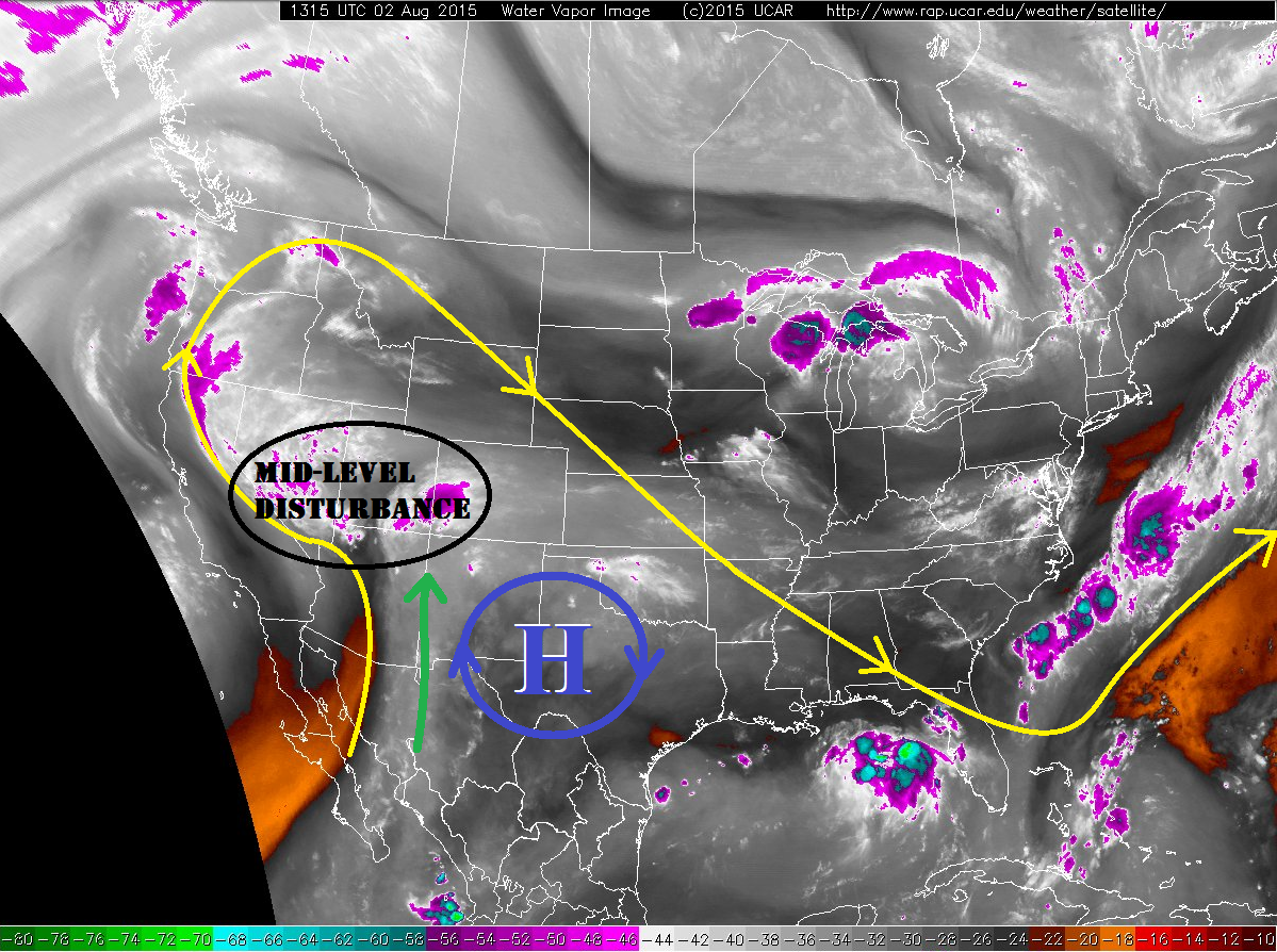
The disturbance will provide the dynamics necessary for scattered-to-widespread showers and thunderstorms across the mountains, with the best coverage across the San Juan Mountains, Southwest Slope, and Grand Valley mountain locations. Locally heavy rainfall will be present with the stronger thunderstorms, and persistent heavy showers with slow storm motions, has heightened flash flood concerns. The burn scars of the West Fork Complex and Little Sand should be watched closely today.
For eastern Colorado, isolated-to-scattered thunderstorms are expected for areas near the interface with the mountains and along the Raton Ridge. Comparable to yesterday, a surface trough is oriented northeast-to-southwest across the Northeast Plains and Palmer Ridge; isolated thunderstorms are expected to develop along this trough, and will be capable of producing strong winds (gusting to 60-65 mph), large hail (> 1 inch), and locally heavy rainfall.
Today’s Flood Threat Map
For more information on today’s flood threat, see the map below (hover over threat areas for more details). For Zone-Specific forecasts, jump below the map.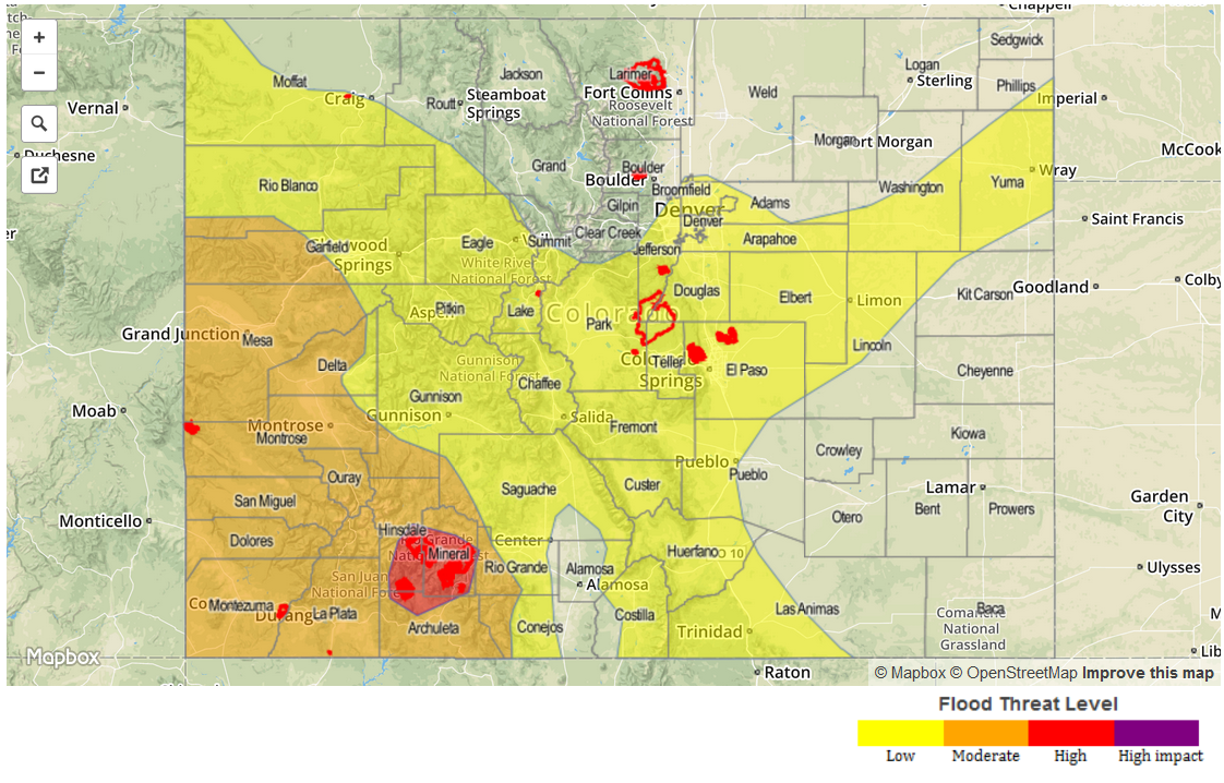
Zone-Specific Forecasts
Urban Corridor, Northeast Plains, Raton Ridge, Palmer Ridge, and Southeast Plains:
Isolated-to-scattered showers and thunderstorms are expected across the areas highlighted by the low flood threat, with a couple of isolated storms expected elsewhere along the Urban Corridor, Northeast Plains near the Cheyenne Ridge, and western portions of the Southeast Plains (namely eastern Pueblo and Las Animas counties). Maximum rain rates are as follows:
Urban Corridor, Palmer Ridge, Northeast Plains and Southeast Plains: 0.8-1.2 inches/hour.
Raton Ridge: 1.0-1.4 inches/hour
Timing: Noon – 10 PM, with a lingering shower/weak thunderstorm possible until the early morning.
Northern Mountains, Front Range, and Central Mountains:
Isolated-to-scattered showers and thunderstorms, with coverage increasing from north to south. Locally heavy rainfall will be possible, and this is accounted for in the low flood threat areas. Maximum rain rates will be 0.8-1.2 inches/hour. Slow-moving storms will be a concern.
Timing: 11 AM – 10 PM, with a few lingering showers over the higher terrain into the early morning hours.
Southeast Mountains, San Luis Valley, San Juan Mountains, Grand Valley, Northwest Slope, and Southwest Slope:
Scattered-to-widespread showers and thunderstorms are expected, with the best coverage across the San Juan Mountains, Southwest Slope, and Grand Valley regions. Fairly slow-moving storms, abundant low-level moisture, and the presence of mid-/upper-level disturbance has heightened flash flood concerns today for locations west of the Continental Divide. Maximum rain rates are as follows:
Southeast Mountains: 0.8-1.2 inches/hour
San Luis Valley, Southwest Slope, Grand Valley, and San Juan Mountains: 1.2-2.0 inches/hour
Northwest Slope: 0.8-1.2 inches/hour
Timing: Current – 10 PM will be primetime, with scattered showers and thunderstorms continuing into tomorrow morning. The heavy rain threat will continue into the overnight hours with the presence of the disturbance.