Issue Date: Tuesday, July 6, 2021
Issue Time: 9:45 AM MDT
Summary:
Monday saw widespread thunderstorm activity across the Northern, Central, and Southeast Mountains, as well as in the San Luis Valley. An isolated storm produced heavy rain in the Southeast Denver Metro Area in the Urban Corridor. The Southwest Slope and Grand Valley also saw measurable precipitation. Storms began to fire up in the high elevations in the early afternoon and became more widespread as the afternoon progressed, resulting in several flood warnings and advisories to be issued, especially for burn areas. These storms were very slow moving, resulting in high rainfall rates and further increasing the flood risk.
Flash flooding was reported on several burn scars across the state:
- Highway 125 in Grand County was closed due to flash flooding and debris flow north of Granby on the East Troublesome burn scar. CoCoRaHS observers in Granby reported 0.14-0.40 inches of rain.
- Further west, I-70 was briefly closed in Glenwood Canyon as a safety precaution after a flash flood warning was issued over the Grizzly Peak burn scar. Minor flow was reported under the interstate drainages, but the highway was ultimately not impacted. I-70 opened shorting after the flash flood warning was downgraded to a watch. The Glenwood Springs area only reported up to 0.13 inches of rain, which shows how sensitive this particular burn scar is.
- In the Grand Valley, the Pine Gulch burn scar also had flooding reported yesterday with minor debris flowing over roadways. Again, only light precipitation was reported over this burn area, between 0.01-0.10 inches in total.
Flooding was not limited to burn scars however, a flash flood was reported near 11-Mile Canyon Reservoir in Park County, which closed highway 9 at milepost 36 due to flooding. Due to the rural location, there are limited precipitation observations in the area.
Heavy rain, up to 2.25 inches in total, was reported in Westcliffe from a nearly stationary severe thunderstorm. While there are no formal flood reports, the language of the severe thunderstorm warning from the NWS indicates flooding was occurring at the time of the warning in the Wet Mountain Valley. County emergency managers reported as much as 1.5 inches of rain in as little as 30 minutes. Nearby observations from various networks reported between 0.70-1.05 inches around the area as well.
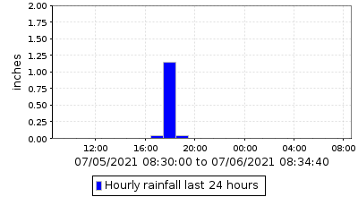
In the Urban Corridor around 4:00 pm, a cell made its way over the Southeast Denver Metro Area and produced a quick 1.0-1.7 inches of rain. Buckley Air Force Base in Aurora reported 1.69 inches. CoCoRaHS observers also in Aurora reported 1.15 inches. A MHFD rain gauge at Mission Viejo Park in Aurora reported 1.22 inches as well, with 1.14 of that falling in a single hour, as seen in the time series plot below. The heavy rain resulted in flood advisory issued for several urban streams.
For rainfall estimates in your area, check out the State Precipitation Map below.
Click Here For Map Overview
