Issue Date: Monday, July 5th, 2021
Issue Time: 10:15AM MDT
— A MODERATE flood threat has been issued for portions of the Front Range, Palmer Ridge, Southeast Mountains and Raton Ridge
— A LOW flood threat has been posted for portions of the Northeast Plains and San Juan Mountains
— The threat will persist later than normal today, lasting into the early overnight hours
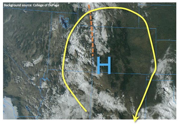
A disturbance of monsoonal origin will rotate around a weak upper-level ridge today causing widespread shower and thunderstorm activity mainly over central and western Colorado today. The disturbance was located along the UT border this morning, already causing mid to high level cloud cover and a few radar returns depicting light showers. With clear skies over the rest of Colorado, plenty of instability will develop to spark slow-moving thunderstorms that will be capable of heavy rainfall. Morning Precipitable Water from the Grand Junction sounding was 0.88 inches, up slightly from yesterday. Meanwhile, the Denver sounding showed a PW of 0.80 inches. Moisture advection into the state is weak today, so moisture levels are anticipated to stay steady or increase slightly later as rainfall moistens the atmosphere.
In terms of placement of heavy rainfall today, there are several factors at play. First, cloud cover is expected to significantly limit instability along and west of the Continental Divide. While short-term moderate to heavy rainfall is certainly possible in this area, 1-hour rainfall intensity is expected to stay below flood threat thresholds. Instead, a general wetting rainfall is expected, which is excellent news for the drought-stricken area. Further east, instability up to 1,100 J/kg is expected to develop in the higher terrain and foothills immediately east of the Continental Divide, which will support heavy rainfall in stronger storms. Furthermore, slow southward storm motion will keep storms generally moving along the higher terrain, which increases the chance for outflow boundaries interacting with the terrain and causing storm training and/or stationary cells. To account for this, a Moderate flood threat has been posted for the Front Range, Palmer Ridge, Southeast Mountains and Raton Ridge. Further east, more scattered storm coverage is expected, which warrants a Low flood threat since storms will still be capable of heavy rainfall. Severe weather will also be possible today, mainly in the form of large hail. Lastly, the timing of the disturbance is such that multiple rounds of heavy rainfall will be possible, persisting into the early overnight hours.
Today’s Flood Threat Map
For more information on today’s flood threat, see the map below. If there is a threat, hover over the threat areas for more details, and click on burn areas to learn more about them. For Zone-Specific forecasts, scroll below the threat map.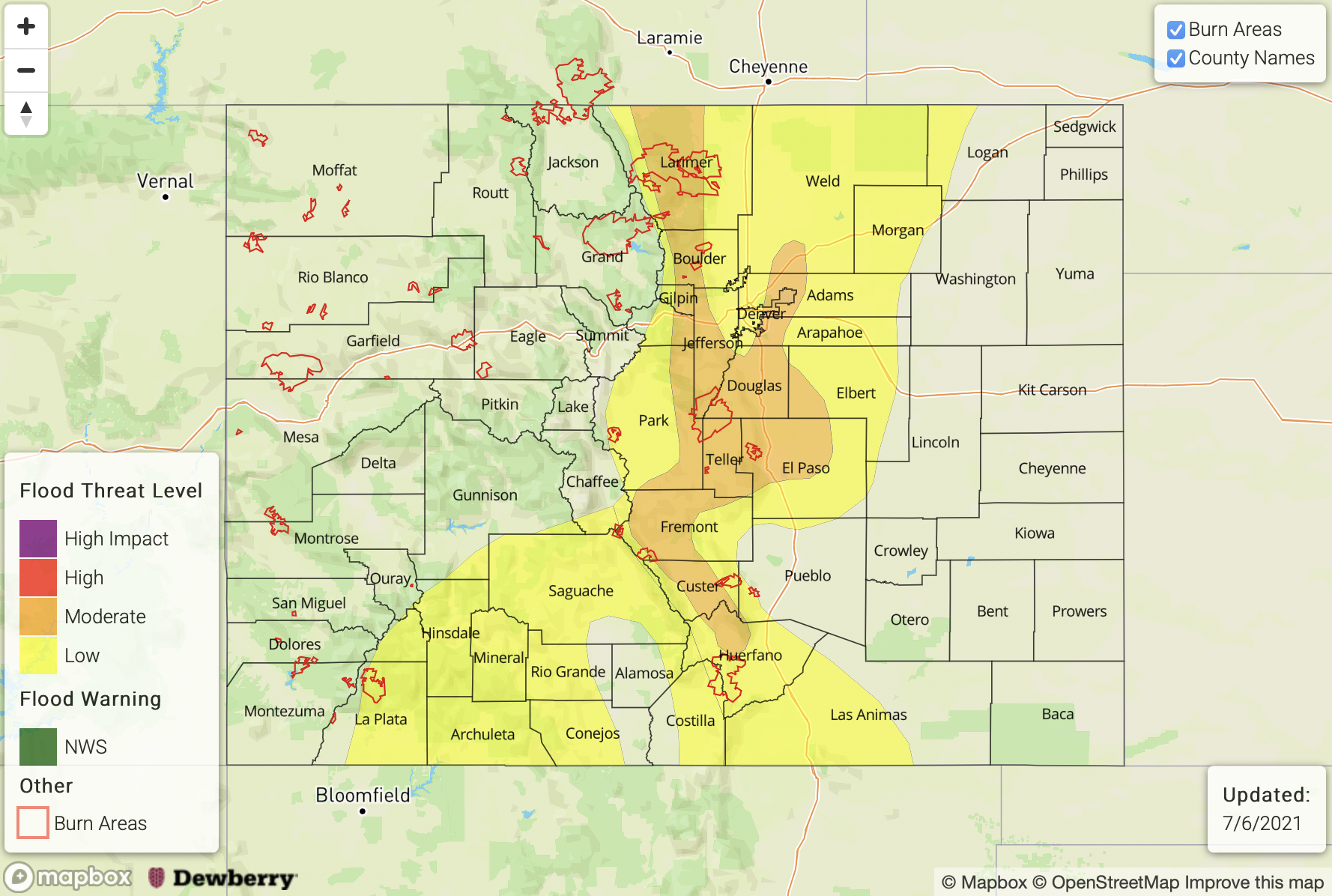
Zone-Specific Forecasts:
Palmer Ridge, Front Range, Southeast Mountains, Raton Ridge, Urban Corridor, San Juan Mountains, Northeast Plains and Southeast Plains:
Multiple rounds of showers and thunderstorms this afternoon and into the late evening. Max 1-hour rainfall up to 2.3 inches. A Moderate flood threat has been posted for the higher terrain and foothills east of the Continental Divide, where max 3-hour rainfall up to 3.4 inches is possible. Threats include flash flooding, debris slides, mud flows and small creek and tributary flooding. A Low flood threat has been posted farther east where storms are expected to be more of the scattered variety. Large hail will be possible with the strongest storms, especially earlier in the afternoon before coverage increases. A Low flood threat has also been posted for the San Juan Mountains where max 1-hour rainfall up to 1.2 inches is possible.
Primetime: 12pm to midnight
Northern Mountains, Central Mountains, Northwest Slope, Grand Valley, Southwest Slope and San Luis Valley:
Numerous showers and thunderstorms expected later this morning, persisting into the late evening. Max 1-hour rainfall up to 0.9 inches, especially earlier in the day before rainfall transitions to a more widespread light-to-moderate intensity type. Total (24-hour) rainfall up to 1.3 inches will be possible, which is excellent news for the drought situation. Outside of the Grizzly Creek and Pine Gulch fire burn areas, flooding is NOT expected today.
Primetime: 12PM through 10PM