Issue Date: Monday, July 5, 2021
Issue Time: 9:45 AM MDT
Summary:
As mentioned in the FTB yesterday, there were a few main areas of higher concern for heavy preciptiation and flooding: high elevations in the Front Range Mountains, Southeast Mountains, Palmer Ridge, and Raton Ridge; and the Southeast Plains.
By late morning, storms already began to develop at high elevations on the Front Range Mountains and Palmer Ridge, warranting flood advisories to be issued, including portions of the Cameron Peak burn area. Due to the slow-moving nature of these storms, rainfall rates were high and capable of producing quick flooding. Flooding was reported on the Cameron Peak burn scar in Glen Haven, as well as another flood report neaby in Estes Park.
As the day progressed, storms eventually made their way eastward onto Urban Corridor and further east on the Palmer Ridge. Up to 0.79 inches was reported in Lyons, and a similar 0.76 inches in nearby Longmont were reported by CoCoRaHS observers. Moving further south, between Centennial and Parker southeast of Denver, 1.18 inches was reported by a CoCoRaHS observer, and many surrounding locations reported between 0.5-1.0 inches of precipitation. Along with the heavy rainfall producing localized flooding in this area, severe-warned storms produced large hail, including 0.75 inch reported. The Colorado Springs area also saw between 0.1 to nearly 1.0 inches across town.
By late evening, storms had developed in the Southeast Mountains and Southeast Plains, with many severe thunderstorm warnings issued for high winds and large hail. Again, these storms were very slow moving and caused localizing heavy rainfall and flooding. Flooding was reported by law enforcement near Coaldale on the Hayden Pass burn area (2016 fire), indicating high waters on several creeks. The full remark is below:
Remark: SOME MUD AND ROCKS ON THE ROAD. COTTONWOOD, LITTLE COTTONWOOD, AND BIG COTTONWOOD ALL HAD HIGH WATERS REPORTED. BUTTER CREEK WAS THE ONLY ONE WITH NOTABLE FLOODING. THE WATERS HAVE ALREADY BEGUN TO RECEDE.
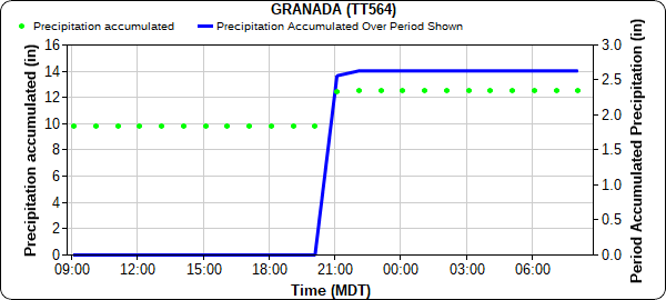
A nearly stationary cell in southeast Colorado resulted in heavy rainfall and flooding. A flash flood was reported in Lamar for street flooding, and Lamar itself picked up between 0.36-1.02 inches across town. Nearby in Granada, just east of Lamar, 2.63 inches was observed! Of that, 2.56 inches of it fell in a single hour, as seen in the time series plot below. The 1-hour (60-minute), 50-year rainfall estimate from NOAA Atlas 14 in Granada is 2.59 inches, making this storm just under a 50-year event.
Since yesterday was Independence Day, there were plenty of eyes on the sky observing the evening storms along with local fireworks shows. Matt Minnillo shared the following video on twitter of fireworks in Falcon and lightning from storms in Lamar.
Nature's fireworks competing with Falcon's fireworks. Storms were all the way down by Lamar. #cowx #coloradosprings pic.twitter.com/5Dp9aO0s6n
— Matt Minnillo (@MattBlueThunder) July 5, 2021
For rainfall estimates in your area, check out the State Precipitation Map below.
Click Here For Map Overview
