Issue Date: Sunday, July 4, 2021
Issue Time: 10:00 AM MDT
Summary:
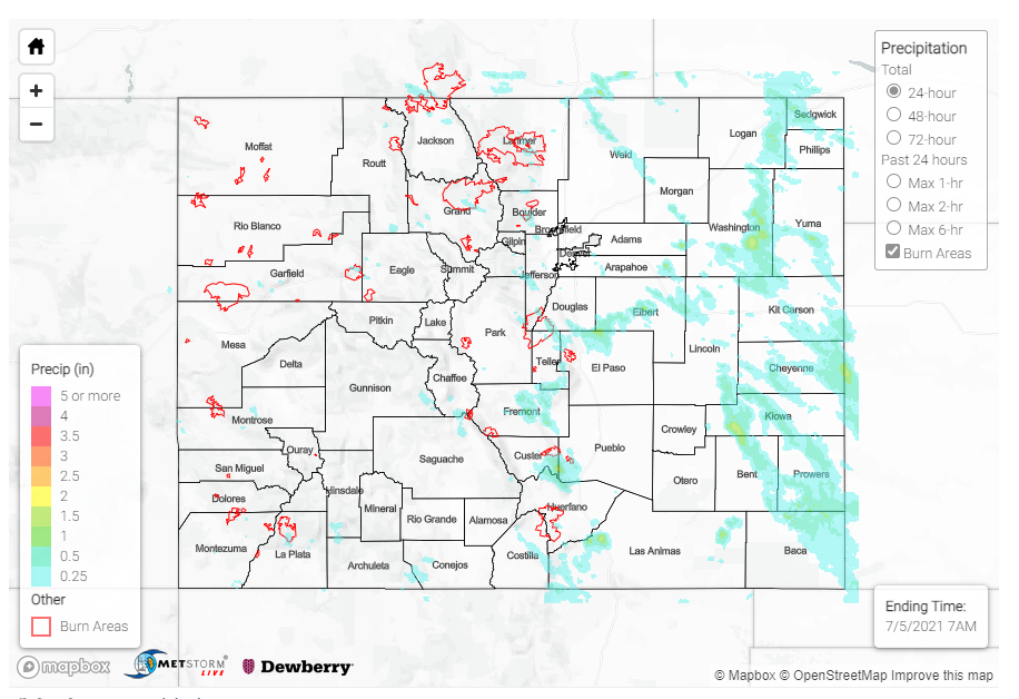
Interstate-70 closed again yesterday due to mud and debris flow in Glenwood Canyon from the Grizzly Creek burn scar. A flash flood warning was issued for a portion of the burn area around 3 pm yesterday afternoon after Doppler radar indicated heavy rainfall from thunderstorms. While not a lot of rain actually fell, as seen in the State Precipitation Map at the bottom of this post, this highlights the canyon’s sensitivity to debris flows after only a small amount of rain on the burn scar. CDOT shared the following images of the Glenwood Canyon closure on twitter:
I-70 Glenwood Canyon Closure. Multiple slides have occurred. Images from the Hanging Lake Tunnels Operations Center. No estimated time of opening. pic.twitter.com/RcCe1pFdqy
— Colorado Department of Transportation (CDOT) (@ColoradoDOT) July 3, 2021
The rest of the western half of the state was mostly dry yesterday, aside from isolated, high elevation thunderstorms activity on the Western Slopes and Northern and Central mountains. On the Southwest Slope, storms produced 0.25-0.4 inch accumulations, including 0.38 inches in Durango. Storm development continued to move eastward over the Front Range Mountains, Urban Corridor, and Eastern Plains and become more organized.
On the Northeast Plains and Palmer Ridge, organized lines of thunderstorms moving southeastward extended from the northeast portion of the state on the Nebraska border all the way Colorado Springs in the early evening. Severe thunderstorm warnings and flood advisories were issued, with the threat of heavy rain, high winds, and large hail. A severe-warned cell dropped 2.00 inches in about an hour in Fleming, CO according to trained spotters, as well as 1.5 inch hail and 60 mph wind gust. Two short-lived landspout tornadoes were also spawned from rotating storms.
Heavy rain was also observed in the Wet Mountains in the Southeast Mountain. Thunderstorms dropped 1.14 inches near Cañon City according to CoCoRaHS observes, who left the following remark:
“We had a downpour from about 3:30 to 4PM yesterday that dropped over an inch of rain and caused some localized minor flooding!”
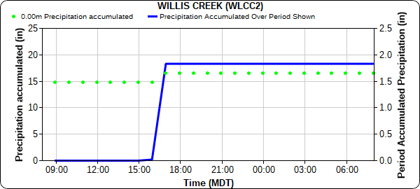
Even higher precipitation totals in the Wet Mountains: 1.44 inches was recorded in San Isabel in from a trained spotter, and 1.83 inches fell at Willis Creek and was observed by the RAWS network. The time series plot of precipitation at Willis Creek below aligns with the Cañon City remark about most of the rain falling in less than hour. Precipitation Frequency Estimates from NOAA Atlas 14 for this region indicate 1.83 inches in an hour is approximately a 17-year rainfall event (or ~6% chance of occurrence any given year).
For rainfall estimates in your area, check out the State Precipitation Map below.
Click Here For Map Overview
Note: The 24-hour, 48-hour and 72-hour total precipitation do not contain bias corrections today due to errors in the CoCoRaHS data. This means there may be underestimations in QPE over the southwest and southeast corners of the state.

