Issue Date: Sunday, July 4th, 2021
Issue Time: 10:15AM MDT
— A LOW flood threat has been issued for portions of the Front Range, Palmer Ridge, Southeast Mountains, Raton Ridge and Southeast Plains
We wish everyone a Happy Independence Day!
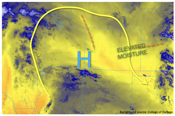
Elevated moisture continues to hang around Colorado on this Sunday. Grand Junction’s PW has fallen slightly to 0.81 inches, still well above normal but with a notable dry layer aloft as well as drying boundary layer suggesting a continued trend of lower storm coverage west of the Continental Divide. East of the Continental Divide, PW at Denver this morning was 0.89 inches, which is well above the average value of about 0.70 inches for early July. There are two features that will support heavy rainfall today. First, a weak disturbance was noted over northwest Colorado, and as this moves slowly east/southeast, it will help trigger scattered to numerous showers and thunderstorms over the higher terrain. With weak northerly steering flow, storms are expected to have a hard time making it into the lower elevations. With elevated moisture levels and plenty of sunshine this morning, a Low flood threat is warranted for basically the entire higher terrain where stronger storms could quickly drop over 1 inch of rainfall in 45-60 minutes before dissipating. Prolific storm cores, capable of causing excessive runoff, have been noted daily for the past 3-5 days and there is nothing to suggest this pattern will end today. In short, moisture is everything in our topographically driven summer circulation. The second feature we are watching is a disturbance moving south over western Kansas, which will trigger strong to severe thunderstorms over parts of the Southeast Plains today. With copious moisture, these slow moving storms will be capable of producing isolated flash flooding, along with severe weather later this afternoon and into the early overnight hours.
Today’s Flood Threat Map
For more information on today’s flood threat, see the map below. If there is a threat, hover over the threat areas for more details, and click on burn areas to learn more about them. For Zone-Specific forecasts, scroll below the threat map.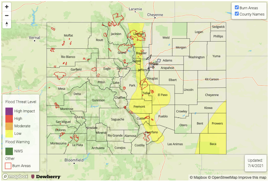
Zone-Specific Forecasts:
Southeast Plains:
Mostly sunny early with scattered to numerous showers and storms developing later this afternoon mainly along the southern KS border. Max 1-hour rainfall up to 2.8 inches will be possible, which warrants a Low flood threat for isolated flash flooding as well as some flooding for smaller creeks and tributaries. Severe weather will also be likely with the stronger storms.
Primetime: 3PM through 2AM
Palmer Ridge, Front Range, Southeast Mountains and Raton Ridge:
Scattered showers and thunderstorms developing this afternoon and lasting into the late evening hours. Max 1-hour rainfall up to 1.3 inches warrants a Low flood threat for isolated flash flooding, debris slides and mud flows especially for higher elevations.
Primetime: 12pm to 9pm
Northeast Plains, Urban Corridor, Central Mountains and Northern Mountains:
Isolated to widely scattered showers and thunderstorms this afternoon and evening with max 1-hour rainfall up to 1.2 inches over the eastern plains to 0.7 inches elsewhere. Flooding is NOT expected today.
Primetime: 12PM through 9PM
San Juan Mountains, Northwest Slope, Grand Valley, Southwest Slope and San Luis Valley:
Isolated to widely scattered showers and thunderstorms this afternoon and evening with max 1-hour rainfall up 0.5 inches. Flooding is NOT expected today.
Primetime: 12PM through 8PM