Issue Date: Saturday, July 3, 2021
Issue Time: 10:00 AM MDT
Summary:
While less eventful than Thursday, Friday saw a continued push of monsoonal moisture into the state. In the early afternoon isolated storms began to develop in the Northwest and Southwest Slopes, Grand Valley, Northern and Central Mountains. Storms moved eastward and became better organized through the afternoon and evening, especially with the ample moisture available. Flood advisories and flash flood warnings were issued up and down the Front Range and Southeast Mountains, including the East Troublesome, Cameron Peak, and Spring Creek burn areas. No flooding was reported in northern Colorado for the East Troublesome and Cameron Peak scars, however there was flooding in La Veta and Walsenburg on the Spring Creek scar.
2.24 inches of rain was reported in La Veta from a CoCoRaHS observer, who also remarked:
“biggest flooding yet. all three drainages from the west AND S Middle Creek from the S. most rain came in one hour afternoon [downpour]. thunder and lightning”
The 2-hour, 25-year recurrence interval precipitation in La Veta, according to NOAA Atlas 14, is 2.23 inches. So the 2.24 observation is just over a 25-year event (or 4% chance of occurrence in any given year). Nearby in Walsenburg, an additional 1.95 inches of rain was reported.
Flash flood warnings were also issued for rural Chaffee County, which received between 0.25-0.5 inches of rainfall near Nathrop (between Buena Vista and Salida). Law enforcement there reported a flash flood of “1-3 FEET OF WATER AND MUD OVER COUNTY ROAD 162″.
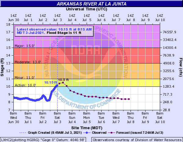
The heavy rain over the last few days in the Arkansas River basin has resulted in higher river flows. The Arkansas River at La Junta quickly rose overnight, and is currently in “Action Stage”, just over 10 feet. 
Further north in the Urban Corridor, hail and localized flooding was reported in Brighton after a severe-warned thundestorm. CoCoRaHs observers reported up to 1.17 inches of rain in 24 hours, and several large hail reports were made through mPing, including a 1.25 inch report. A flood advisory was also issued for this area.
In the central mountains, 0.25 inch hail was reported on the Sylvan Fire associated with spotty shower activity and isolated 0.5 inches of rain
For rainfall estimates in your area, check out the State Precipitation Map below!
Click Here For Map Overview
