Issue Date: Saturday, July 3rd, 2021
Issue Time: 9:45AM MDT
— A LOW flood threat has been posted for parts of the Palmer Ridge, Northeast Plains, Southeast Mountains and Raton Ridge
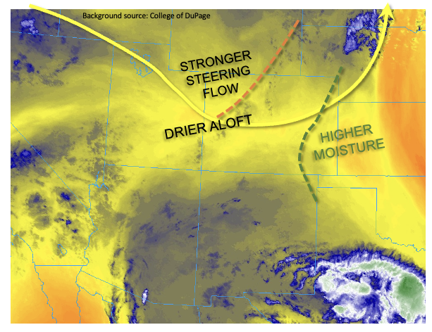
This morning’s atmosphere over Colorado continues to be described as generally disorganized flow, typical of summertime over our area. However, there are a couple of features that will be key to today’s weather, as shown in the low-level water vapor image below. A ripple in the flow, a.k.a. an shortwave disturbance, was noted over southeast Wyoming stretching southwestward into western Colorado. This disturbance will trek east/southeastward around a weak upper level ridge centered over the Four Corners. Scattered to numerous showers and thunderstorms will accompany it mainly over the Northeast Plains and Southeast Plains. However, one important difference with this disturbance and those of prior days is the much stronger steering flow aloft. Storm motion is expected to increase to 20-25 mph for northeast Colorado, which will generally limit point rainfall for most of the region. Nonetheless, with elevated moisture levels in eastern Colorado, a Low flood threat has been posted for parts of eastern Colorado, where outflow boundaries interacting with the Palmer Ridge terrain could provide for a period of storm training later this afternoon. Additionally, the stronger winds aloft are expected to increase the chances of a bow-echo type convective system dominated by low level outflow, which will cause damaging winds over parts of eastern Colorado if this system materializes as guidance suggests.
An additional area of Low flood threat has been posted for parts of the Raton Ridge and Southeast Mountains, where weak upslope flow and plenty of low-level moisture will support slow-moving cells capable of localized heavy rainfall and excessive runoff.
West of the Continental Divide, this morning’s PW at Grand Junction was a rather high 0.85 inches, but the profile showed a drying boundary layer as well as a marked layer of dry layer aloft. With PW expected to drop over western Colorado, we expect lower storm coverage there today.
Today’s Flood Threat Map
For more information on today’s flood threat, see the map below. If there is a threat, hover over the threat areas for more details, and click on burn areas to learn more about them. For Zone-Specific forecasts, scroll below the threat map.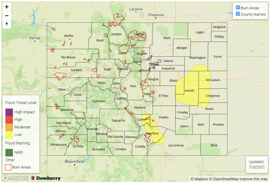
Zone-Specific Forecasts:
Northeast Plains, Palmer Ridge, Southeast Plains, Southeast Mountains and Raton Ridge:
Scattered to numerous showers and thunderstorms this afternoon and into late evening. Max 1-hour rainfall up to 2.0 inches (east) and 1.2 inches (west). Up to 3.5 inches of storm total rainfall will be possible over the eastern parts of the Palmer Ridge and Northeast Plains. A Low flood threat has been posted for isolated flash flooding over the plains. Over steeper terrain of the Southeast Mountains and Raton Ridge, debris slides and mud flows will be possible under the strongest storms.
A bow echo could develop across eastern Colorado this afternoon, which could cause damaging winds exceeding 60mph. Stay tuned to local NWS offices for warnings.
Primetime (south): 12pm to 9pm
Primetime (east): 2pm to midnight
Front Range, Urban Corridor, Central Mountains and Northern Mountains:
Scattered showers and thunderstorms this afternoon and into early evening. Max 1-hour rainfall up to 0.9 inches (below 5,500 feet) and 0.7 inches (above 5,500 feet). Flooding is NOT expected today. Gusty winds could accompany the strongest storm cells especially towards the WY border.
Primetime: 12PM through 8PM
Northwest Slope, Grand Valley, Southwest Slope, San Juan Mountains and San Luis Valley:
Widely scattered showers and storms this afternoon and evening mainly over the higher terrain. Max 1-hour rainfall up to 0.6 inches. Flooding is NOT expected today.
Primetime: 12PM through 8PM