Issue Date: Wednesday, June 30, 2021
Issue Time: 9:30 AM MDT
Summary:
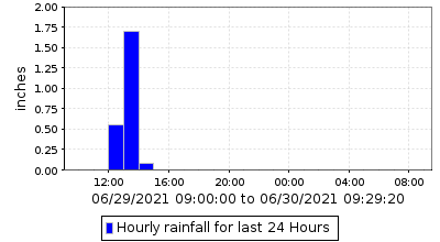
High elevation thunderstorms began to develop in the early afternoon yesterday. A cell west of Conifer produced very heavy, short-duration rainfall and was able to be observed by both CoCoRaHS and UDFCD networks. The Brook Forest Precipitation Station west of Conifer recorded 2.32 inches in 24-hours with most of it, 1.69 inches, falling within a single hour, as seen in the 24-hour time series plot below. Nearby, a CoCoRaHS station recorded 1.29 inches in 24-hours, with a remark that “All but .01 of rain was received in less then an hour in the afternoon.”
According to NOAA Atlas 14 precipitation frequency estimates for this area, a 1-hour rainfall rate of 1.69 inches is approximately a 47-year rainfall event (or 0.21% chance of occurring in any given year). A flood advisory was issued associated with this heavy rain, but no flooding was reported.
Similar high elevation, high rainfall rate storms developed throughout the Northern, Central, and Front Range mountains in the afternoon and evening. A flood advisory was also issued for the East Troublesome burn area yesterday, but again no flooding reported. Lastly, a flash flood warning was issued again for the Grizzly Creek burn area in Glenwood Canyon. Thankfully no flooding was reported yesterday, and I-70 has remained open since the two closures over the weekend from mud and debris flows.
The Southwest Slope continued to benefit from monsoonal moisture making its way up from the southwest. Widespread, long lasting storms began in the afternoon and dropped 0.25-0.50 inches, with localized even higher rainfall amounts. While hourly rainfall rates were low, 0.68 inches was recorded at a Mancos CO-OP station and up to 0.94 inches at nearby CoCoRaHS stations. Portions of the Grand Valley also received beneficial moisture.
No flooding was reported on Tuesday. For rainfall estimates in your area, check out the State Precipitation Map below.
Click Here For Map Overview
