Issue Date: Tuesday, June 29, 2021
Issue Time: 9:20 AM MDT
Summary:
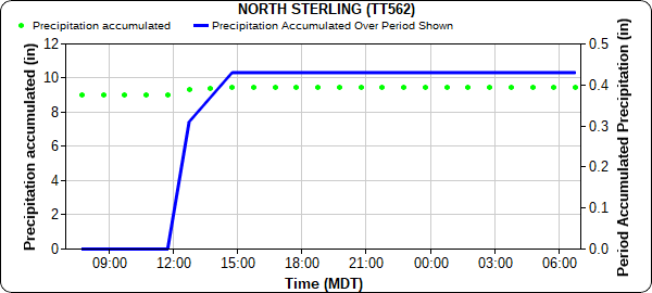
Yesterday began with a north-south oriented line of thunderstorms developing in the late morning on the Colorado-Nebraska border east of Pawnee National Grasslands. As the line moved eastward, North Sterling picked up a quick 0.44 inches in a little under 3-hours as the storms passed, as seen in the plot below. Nearby, rainfall totals in the area end up around 0.25-0.50 inches.
By early afternoon, scattered showers also formed along the Front Range Mountains before making their way eastward across the Urban Corridor and Northeast Plains. A flood advisory was issued in Larimer County due to rain over the eastern side of the Cameron Peak burn area, however no flooding was ultimately reported. Rainfall rates in the Urban Corridor were low, also resulting in minimal accumulations.
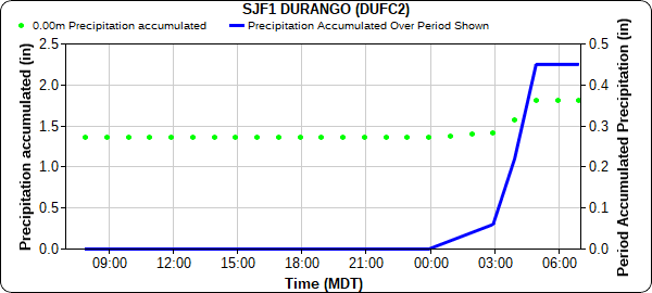
Overnight into the early morning hours, storms on the Southwest Slope provided a quick burst of rainfall. Durango received 0.45 inches overnight shortly after 3:00 am, seen below. Similar rainfall totals, 0.25-0.50 inches, were scatted across Montezuma, La Plata, and Dolores Counites.
No flooding was reported on Monday. For rainfall estimates in your area, including antecedent conditions, check out the State Precipitation Map below.
Click Here For Map Overview
