Issue Date: Sunday, June 27th, 2021
Issue Time: 10AM MDT
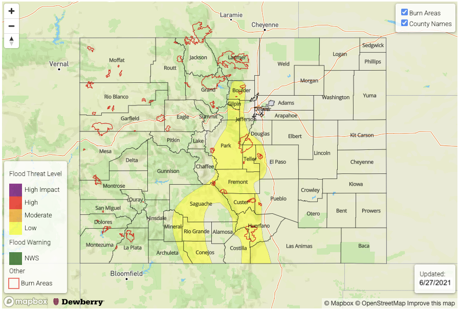
— A LOW flood threat has been issued for the Southeast Mountains and portions of the Front Range, Central Mountains and San Juan Mountains
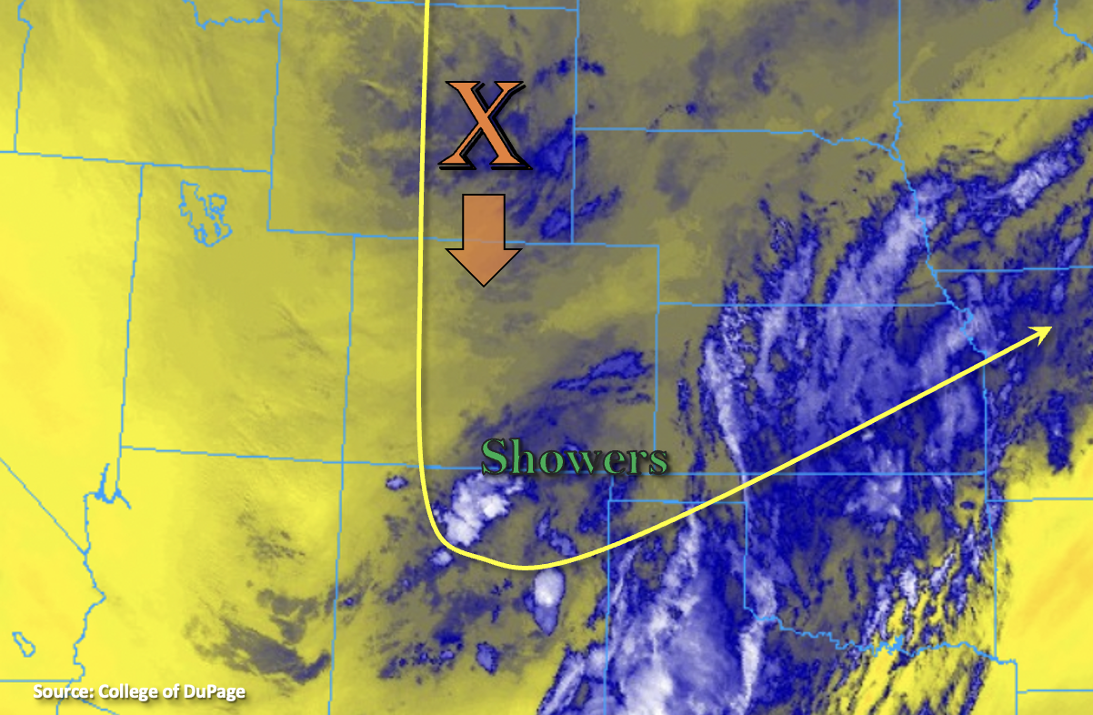
Not much change in the overall pattern today as Colorado continues to reside on the east side of a strong High pressure system over the Pacific Northwest. The trough overhead will build the northeast throughout today, which will produce northerly steering flow for storms over western Colorado and the mountains and then northwest/westerly flow over the eastern foothills/adjacent plains. Elevated moisture also remains over the area, although there is a slight decrease from yesterday. More so west of the Continental Divide. PW was measured at 0.72 inches in Denver and 0.64 inches over western Colorado. There is a second pocket of moisture across the southern border, which is producing some rainfall over the Raton Ridge this morning. In addition to the diurnal flow pattern sparking scattered afternoon storms over the mountains, a well-defined shortwave (orange “X”) will move through the northerly flow from Wyoming this afternoon. The incoming lift and moisture boost should help to produce more numerous storms over the mountains with training storms helping to increase local accumulations as seen over the last couple of days.
That brings us to the flood threat for today. It has rained a lot over the mountains the last couple of days. Yesterday, the northern Southeast Mountains and Wet Mountains received between 1 and 1.50 inches of rainfall with totals around 0.75 inches across the southern Front Range. On Friday, the southern Front Range saw the 1 to 1.50 inch rainfall totals. Some stronger storms are also possible this afternoon over the southern San Juan Mountains, which have received between 0.75 and 1.00 inches over the last 48-hours. So, with another round of rainfall expected over these same regions this afternoon, the threat for mud flows, debris slides and excessive runoff increases within the steeper terrains. Thus, a Low flood threat has been issued.
Today’s Flood Threat Map
For more information on today’s flood threat, see the map below. If there is a threat, hover over the threat areas for more details, and click on burn areas to learn more about them. For Zone-Specific forecasts, scroll below the threat map.
Zone-Specific Forecasts:
Southeast Mountains, Front Range, San Juan Mountains, Central Mountains & San Luis Valley:
Over the Southeast Mountains and Front Range, max 1-hour rain rates up to 0.60 inches will be possible with general storm totals between 0.60 and 0.90 inches. Over the Central Mountains and San Juan Mountains near the Continental Divide, max 1-hour rain rates up to 0.60 inches are forecast with storm totals just under an inch (south) possible. The interior/exterior San Luis Valley will likely see totals up to 0.45 inches/0.60 inches.
Another round of rainfall paired with antecedent precipitation over the last 48-hours mean saturated and loosened soils over these steeper terrain regions. Thus, the forecast rainfall this afternoon will increase the threat for mud flows, debris slides and excessive runoff in local streams/creeks. So, a Low flood threat has been issued. Rain turns to snow by this evening for the highest elevations, which should decrease the flood threat after about 8PM.
Primetime: 11:30AM to Midnight
Urban Corridor, Raton Ridge, Palmer Ridge, Northeast Plains & Southeast Plains:
Similar to yesterday, the more westerly component to the steering flow will push storms off the mountains and ridges by early afternoon. Additional storms will likely move into the Northeast Plains from the north later in the day. While some thunderstorms may develop with hail and brief outflow winds, severe storms are not expected at this time. Max 1-hour rain rates up to 0.75 inches will be possible over the ridges with storm totals around 1 inch. The far eastern plains will likely see storm totals around 0.75 inches. Some storms over the Southeast Plains & Palmer Ridge may linger through tomorrow morning. Flooding is NOT expected.
Primetime: 2PM to Ongoing
Northern Mountains, Grand Valley, Northwest Slope & Southwest Slope:
With the decrease in moisture over the area and northerly component to the steering flow, no rainfall is forecast this afternoon over the lower elevations. Some afternoon showers will likely develop over the Northern Mountains near the Divide, but totals should remain under 0.40 inches. Light rainfall is also possible over the Northwest Slope this evening from storms moving across the northern border. Flooding NOT forecast today.
Primetime: 3PM to 9PM