Issue Date: Friday, June 25th, 2021
Issue Time: 10:40AM MDT
— A MODERATE flood threat has been issued for portions of the Front Range and Urban Corridor
— A LOW flood threat has been issued for the Northwest Slope, Grand Valley, Northern Mountains, Central Mountains, Southeast Mountains, Palmer Ridge, Northeast Plains and Southeast Plains
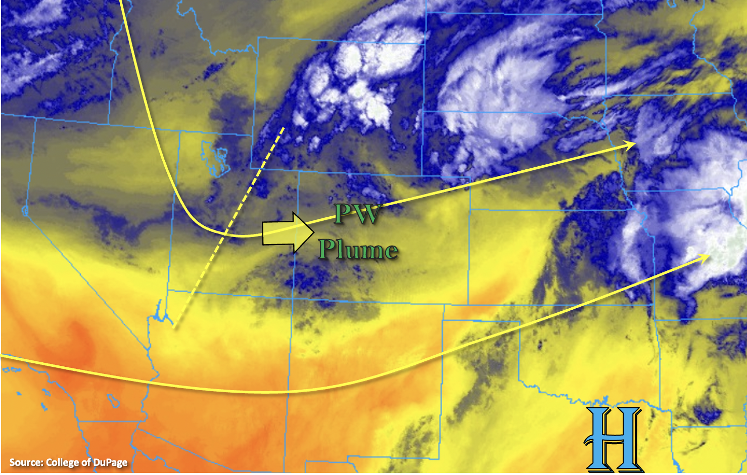
The moisture plume from the last couple days is still over the state, which can be seen by the blue and white shades in the water vapor imagery below and high dew points across the state (not shown). Dew points over northwest Colorado are around 50F (!), and Grand Junction’s morning sounding is still showing elevated moisture throughout the atmosphere with PW around 0.90 inches. It’s the same story over eastern Colorado with dew points in the mid to upper 50Fs and PW around 0.85 inches (Denver). As the state transitions into a weak trough pattern today, mid-level lift will increase over the area. This paired with the higher moisture will aid in the development of numerous storms over the mountains and elevated ridges by noon. Storms are expected to spill into the adjacent eastern plains by mid-afternoon and as they encounter higher instability (east), storms are expected to intensify. So, expect some severe thunderstorm over the far eastern plains that could produce strong outflow winds and large hail along with heavy rainfall. Early this evening, a weak cool front boundary will drop across the northern border, which will help to produce additional storms over the Urban Corridor, Palmer Ridge and eastern plains that are forecast to last into the overnight hours. So this is an overnight threat.
Training storms and additional storms sparked by outflow boundaries today are expected to produce high 30-minute rain rates and 2-3 hour accumulations, so a Low flood threat has been issued. Threats over the steeper terrains include mud flows, debris slides and road flooding. Although less convective storms are forecast overnight along the southern Front Range and Urban Corridor, persistent rainfall in the moisture-rich environment today and tonight are expected to produce local heavy rainfall with isolated 24-hour totals up to 2.75 inches by morning. Thus, a Moderate flood threat has been issued.
Please check the Fire Burn Forecast Page as there are several elevated threats issued for the burn areas today.
Today’s Flood Threat Map
For more information on today’s flood threat, see the map below. If there is a threat, hover over the threat areas for more details, and click on burn areas to learn more about them. For Zone-Specific forecasts, scroll below the threat map.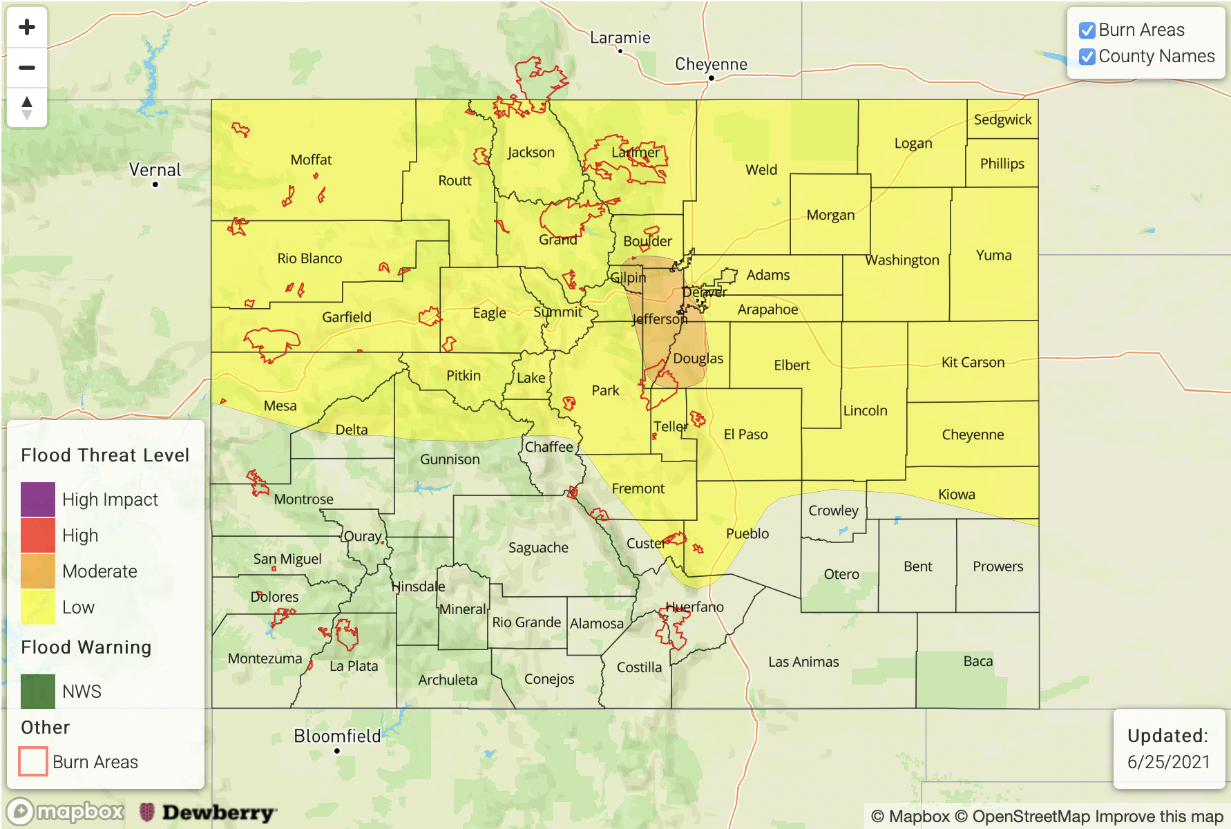
Zone-Specific Forecasts:
Front Range & Urban Corridor:
Storms today are expected to fire over the high terrains by noon and move into the Urban Corridor by mid-afternoon. Initially, the convective storms will be possible of producing 1-hour rain rates up to 1.25 inches with two hour totals just over 2 inches. Behind a cool front tonight, persistent upslope flow will produce another round of showers in the Moderate threat area. Isolated storm totals accumulations up to 2.75 inches will be possible by morning. Flood threats include road flooding and mud flows/debris slides over steeper terrains.
Primetime: 3PM to ongoing
Grand Valley, Northwest Slope, Central Mountains & Northern Mountains:
Scattered storms are forecast to develop over the elevated mountains and ridges by late this morning as a shortwave energy moves overhead. Max 1-hour rain rates up to 0.75 inches will be possible, and 2-hour totals from training storms could produce isolated totals up to 1.50 inches. Flood threats include mud flows, debris slides and road flooding over steeper terrains. Linger rainfall is likely over the mountains and Northwest Slope overnight. A Low flood threat has been issued.
Primetime: 11AM to Midnight
Palmer Ridge, Northeast Plains & Southeast Plains:
Ongoing rainfall over the northeast corner will continue and may intensify a bit this morning. Some severe thunderstorms are possible this afternoon further east where there is some better instability as storms move in from the west. The main threats from those storms will be heavy rainfall, large hail and strong outflow winds. Max 1-hour rain rates up to 1.75 inches (north) and 1.25 inches (south) will be possible. Training storms (north) may produce 2 to 3 hour totals up to 2.50 inches, which could cause local flooding of streams, road and field ponding. A Low flood threat has been issued. Late night storms/showers are possible over the Palmer Ridge, but rain rates should remain under 0.60 inches.
Primetime: 3:30PM to Midnight
Southwest Slope, San Juan Mountains, San Luis Valley, Raton Ridge and Southeast Mountains:
Scattered afternoon storms are expected over these regions with more coverage east than west. Max 1-hour rain rates up to 0.40 inches are possible over the mountains with storm totals just over 0.50 inches possible (west). Over the Raton Ridge, max 1-hour rain rates up to 0.60 inches are possible. A second round of overnight showers are possible in the Southeast and San Juan Mountains, and flooding is NOT forecast.
Primetime: 1PM to 1AM