Issue Date: Saturday, June 19th, 2021
Issue Time: 9:45AM MDT
— A LOW flood threat has been posted for parts of the Northeast Plains, Southeast Plains and Palmer Ridge
As shown in the visible satellite image, below, a much weaker version of the long-lasting upper-level ridge continues to be centered over the Four Corners. The big change over the past 24-hours across Colorado has been an increase in moisture statewide. Dewpoint temperatures have risen 4-6F both east and west of the Continental Divide. PW has increased from 0.59 to 0.66 inches in Denver, and has held steady around 0.78 inches at Grand Junction (which is above normal for this time of year). However, as has been the case for the better part of a week, this moisture continues to be very shallow in the boundary layer, and concentrated mainly in the mid and upper levels. Nonetheless, the increase in moisture will support more widespread shower and storm activity this afternoon and evening. In addition to moisture, there is a pronounced shortwave disturbance entering northwest Colorado. This is already causing showers and a few weak thunderstorms in a moisture-starved environment. As this feature moves east-southeast and encounters more moisture and instability, expect higher intensity and more widespread rainfall. There are a few factors mitigating the heavy rainfall threat today. First, cloud cover over northern Colorado will likely limit instability to localized pockets, which will limit thunderstorm core size and thus make storms more prone to dry air entrainment. This will likely affect most of the Front Range and Urban Corridor throughout the day. Additionally, steering winds will increase markedly this afternoon over northern Colorado, and will help limit rainfall at any given location.
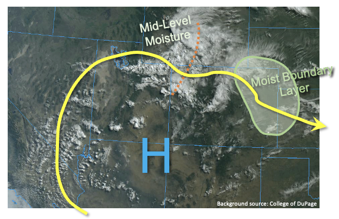
In terms of sensible conditions, we expect a quick increase in shower and storm activity, first over the higher terrain, then spreading eastward into the plains during early afternoon. Multiple rounds of rainfall are likely as the June sunshine will quickly recover any lost instability after a storm passes through. Two areas have been placed under a Low flood threat. First, over the Palmer Ridge, steering flow will be weaker and instability is expected to be maximized with limited cloud cover. With dewpoint temperatures exceeding 50F east of Colorado Springs, storms will be capable of heavy rainfall and isolated flash flooding at the 1-hour duration. Second, along the KS border of the Northeast Plains, we expect moderately strong moisture advection from the southeast this afternoon and evening to provide for a 3-6 hour period of heavy rainfall, warranting a Low flood threat for isolated flash flooding. Large hail, damaging wind and an isolated tornado will also be possible here.
Finally, west of the Continental Divide, although rain chances will increase mainly over the higher terrain, the result will be bittersweet as dry lightning will become a major concern this afternoon due to limited boundary layer moisture. A Red Flag Warning has been posted for most of the region through early evening.
Today’s Flood Threat Map
For more information on today’s flood threat, see the map below. If there is a threat, hover over the threat areas for more details, and click on burn areas to learn more about them. For Zone-Specific forecasts, scroll below the threat map.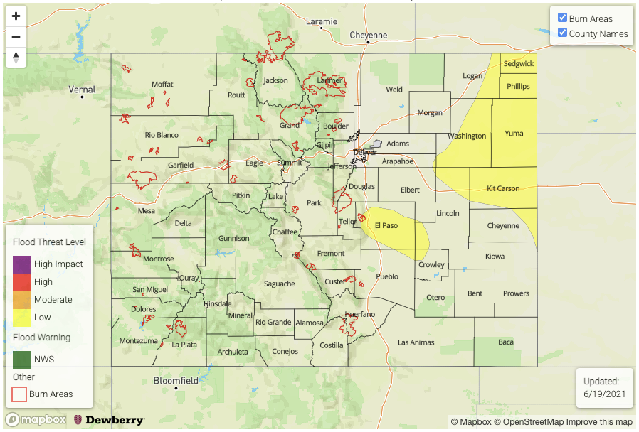
Zone-Specific Forecasts:
Northeast Plains, Southeast Plains and Palmer Ridge:
Partly to mostly cloudy with widespread showers and thunderstorms this afternoon and into the early overnight hours, especially over northern areas. Max 1-hour rainfall up to 2.1 inches (north) and 1.3 inches (south) warrants a Low flood threat for isolated flash flooding and higher elevation debris slides and mud flows. Max 3-hour rainfall up to 3.2 inches will be possible along the KS border. Large hail, damaging winds and an isolated tornado will also be possible, mainly over the Northeast Plains.
Primetime: 12PM through 2AM
Front Range, Urban Corridor, Raton Ridge, Southeast Mountains:
Mostly cloudy with scattered to numerous showers and thunderstorms this afternoon and evening. Max 1-hour rainfall up to 1.0 inch could cause nuisance street flooding in urban areas, but that aside, flooding is NOT expected. Large hail and damaging winds could accompany the strongest storms.
Primetime: 12PM through 9PM
San Luis Valley, Grand Valley, Southwest Slope and Northwest Slope, Central Mountains, Northern Mountains and San Juan Mountains:
Variable cloudiness with scattered to numerous higher elevation showers and weak thunderstorms this afternoon and early evening. Max 1-hour rainfall up to 0.6 inches. Dry lightning is a major concern this afternoon, and a Red Flag Warning has been issued mainly for lower elevations. Flooding is NOT expected today.
Primetime: 12PM through 8PM