Issue Date: Friday, June 18th, 2021
Issue Time: 10:25AM MDT
— A LOW flood threat has been issued for the Northeast Plains, Palmer Ridge and portions of the Urban Corridor and Southeast Plains
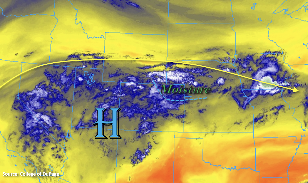
Slightly cooler temperatures are forecast today over eastern Colorado as a cold front continues to push through the state this morning (blue dashed line below). The passing Low that helped flatten the ridge to our north and the upper High itself has returned moisture to the state (blue/white shades below). Deeper surface moisture is expected behind the front, and PW has already begun to rise at Denver (0.59 inches). Back to the west, the moisture is located more in the mid and upper levels of the atmosphere. Grand Junction’s sounding measured PW at 0.77 inches, which is expected to help produce moderate rainfall accumulations over the Central and San Juan Mountains this afternoon with training storms.
Over eastern Colorado, afternoon post-frontal upslope flow with the moisture return is expected to produce scattered to numerous storms over the mountains. As storms move off the mountains to the east with the westerly flow aloft, they will move into higher moisture and instability. The stronger storms that develop will also be capable of producing heavy rainfall, which could produce some localized flash flooding issues. Best chance for these storms will be over the elevated ridges. The front looks to stall somewhere over the Southeast Plains late this afternoon. Additional storms may develop along it later tonight, and the extra convergence may help to produce training storms capable of heavy rainfall. Thus, a Low flood threat has been issued.
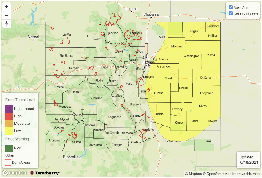
Today’s Flood Threat Map
For more information on today’s flood threat, see the map below. If there is a threat, hover over the threat areas for more details, and click on burn areas to learn more about them. For Zone-Specific forecasts, scroll below the threat map.
Zone-Specific Forecasts:
Southeast Mountains, Front Range, Urban Corridor, Palmer Ridge & Raton Ridge:
Numerous storms are forecast develop over the mountains this afternoon with the post-frontal upslope flow. Max 1-hour rain rates up to 0.25 inches will be possible over the southern Front Range and Southeast Mountains. Westerly steering flow will push the storms east where they will encounter some higher moisture. As this occurs, stronger storms should begin to develop that will be capable of producing heavy rainfall, hail and strong outflow winds. Best chance for the more severe storms will be over the elevated ridges where max 1-hour rain rates may reach 1.25 inches. A Low flood threat has been issued for the adjacent plains where road flooding and ponding in low-lying areas may occur.
Primetime: 3PM to 9PM
Northeast Plains & Southeast Plains:
Deeper moisture return is expected over these areas as well as an increase in convergence along the front (south). Max 1-hour rain rates with training storms (south) may reach up to 2.25 inches. Further north, max 1-hour rain rates up to 1.75 inches will be possible. A Low flood threat has been issued for possible flash flooding of roads, fields and local streams. The severe storms that develop will also likely produce hail and strong outflow winds. Storms may linger into early tomorrow morning.
Primetime: 8PM to 3AM
Grand Valley, Southwest Slope, San Luis Valley, Northwest Slope, San Juan Mountains, Central Mountains & Northern Mountains:
Increased mid and upper level moisture, paired with the diurnal flow and mid-level energy, will help to return scattered afternoon storms to the Central/San Juan Mountains as well as the elevated plateaus of the Northwest/Southwest Slopes. While some evaporation will occur, moderate accumulations will still be possible with training storms. Max 1-hour rain rates up to 0.20 inches (west), 0.50 inches (Central Mountains) and 0.75 inches (San Juan Mountains) will be possible. Strong outflow winds and lightning will be the main threats. Flooding is NOT forecast.
Primetime: 2PM to 9PM