Issue Date: Thursday, June 17th, 2021
Issue Time: 9:20AM MDT
— Flooding is NOT expected today
Today will be the last day of the recent record-breaking heat wave, as the upper-level ridge will finally begin to weaken this afternoon. Unfortunately, this means another day of record or near-record temperatures for most of the state. As shown in the visible satellite image, below, the ridge is centered over southwest Colorado this morning and has weakened slightly over the past 24 hours. Some monsoonal-type mid and high-level moisture has found its way around the northern periphery of the ridge this morning. Grand Junction’s PW has increased from 0.48 to 0.58 inches over the past 24 hours with most of the increase coming in the mid and upper-levels. Nonetheless, this will support a slight increase in storm coverage west of the Continental Divide, although only light precipitation is expected there today.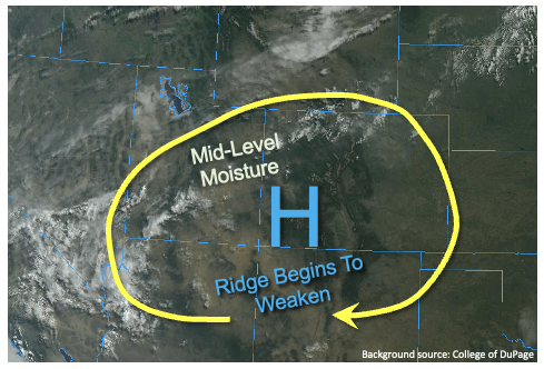
East of the Continental Divide, dewpoint temperatures have generally dropped by 2-4F since yesterday morning. Denver’s PW is up slightly from 0.49 to 0.54 inches this morning driven mainly by increases above the boundary layer. Boundary layer moisture continues to be very shallow, and slight drying since yesterday, especially along the KS/NE border, suggests a reduction in storm coverage and peak rainfall intensity today.
Overall, we expect another round of isolated to widely scattered shower and thunderstorm activity mainly limited to the higher terrain as well as the Southeast and Northeast Plains. Weak steering flow and marginal instability implies storms will have a hard time staying intact for more than 30 minutes. Pulses of moderate rainfall are expected today, but there is no flood threat. Isolated large hail will also be possible with the strongest storms in the eastern plains.
Today’s Flood Threat Map
For more information on today’s flood threat, see the map below. If there is a threat, hover over the threat areas for more details, and click on burn areas to learn more about them. For Zone-Specific forecasts, scroll below the threat map.
Zone-Specific Forecasts:
Northeast Plains and Southeast Plains:
Continued very hot today with widely scattered showers and thunderstorms this afternoon and evening. Max 1-hour rainfall up to 1.4 inches, locally. Large hail could accompany the strongest cells.
Primetime: 1PM through 10PM
Front Range, Urban Corridor, Palmer Ridge, Raton Ridge, Southeast Mountains:
Continued very hot with isolated to widely scattered showers and thunderstorms this afternoon and evening. Max 1-hour rainfall up to 0.5 inches above 6,000 feet and 0.8 inches for lower elevations. Flooding is NOT expected today.
Primetime: 12PM through 9PM
San Luis Valley, Grand Valley, Southwest Slope and Northwest Slope, Central Mountains, Northern Mountains and San Juan Mountains:
Partly cloudy and continued very hot today with isolated to widely scattered showers and weak storms possible, mainly over the San Juan Mountains and Central Mountains. Max 30-minute rainfall up to 0.5 inches. Flooding is NOT expected today.