Issue Date: Sunday, June 13th, 2021
Issue Time: 9:50AM MDT
— A LOW flood threat has been issued for portions of the Urban Corridor, Northeast Plains and northern Southeast Plains. This flood threat is an overnight threat.
A decent plume of moisture has worked its way under the ridge thanks to clockwise rotation around a surface High located in Missouri/Iowa. This plume is outlined in the green below, and the high surface moisture is helping to produce fog and cloud cover over the northeast corner of Colorado this morning. Out over the west border, it’s quite the opposite story. It remains incredibly dry (no rainfall forecast), and excessive heat becomes an issue this afternoon with highs forecast to reach over 100F for the Grand Valley.
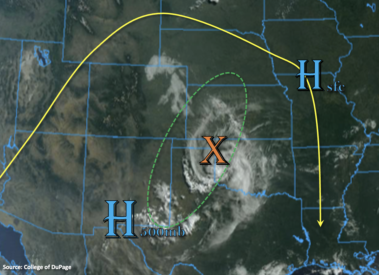
Over eastern Colorado, PW at Denver has nearly doubled from yesterday morning to 0.68 inches. Equally important is that as you move towards the eastern border and closer to the plume, PW increases to an inch or above. So, it is very humid this morning with dew points at or above 60F. South/southeast flow at the surface around the aforementioned High and from the diurnal flow pattern should help to keep the moisture somewhat intact throughout the day despite the dry westerly/southwesterly flow aloft continuing.
A couple storms are expected to fire over the eastern elevated ridges this afternoon, which will drift southeast towards the High to our south. Then, a separate set of storms is expected to develop to our north late this afternoon and evening along a convergence boundary (cool front). These PM storms to our north are likely to spread in coverage and intensity as they move south/southeast into the higher moisture and the left exit region of the low level jet (increased lift). As the cluster of storms cross over the border tonight, widespread convection in a high moisture environment could cause flooding issues, if instability can hold on. Thus, a Low flood threat has been issued overnight. In addition to heavy rainfall, the more severe storms could produce large hail and damaging outflow winds tonight.
Today’s Flood Threat Map
For more information on today’s flood threat, see the map below. If there is a threat, hover over the threat areas for more details, and click on burn areas to learn more about them. For Zone-Specific forecasts, scroll below the threat map.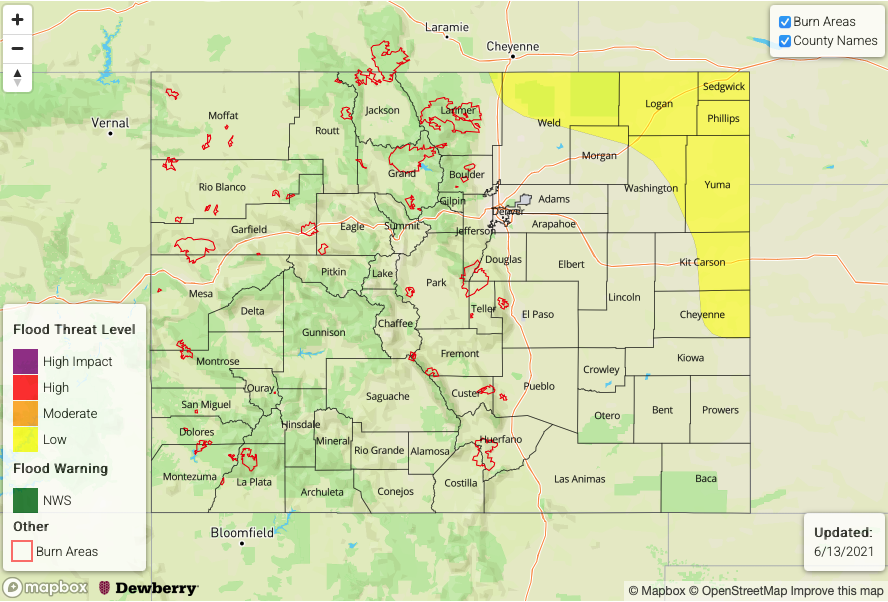
Zone-Specific Forecasts:
Northeast Plains, Southeast Plains & Urban Corridor:
Heavy rainfall may be possible this evening and overnight for these regions. Back to the west over the northern Urban Corridor, the first set of storms that develop over the Cheyenne Ridge are expected to drift across the border by early this evening. With elevated moisture in the area, instability still present, slow steering flow and southeast/east flow increasing, training storms may produce storm totals just over 1 inch.
Later tonight, a second set of storms are expected to cross the northern border further east. While some of the morning model runs have been backing off the convection (rapidly decreasing instability overnight), if instability can hang on, numerous outflow boundaries will likely trigger additional convection over the Northeast Plains. With elevated surface dew points present, heavy rainfall becomes a concern alongside large hail and damaging outflow winds under the more severe storms. Isolated storm totals up to 2.75 inches will be possible, so a Low flood threat has been issued. Flood threats would include road flooding, field ponding and local stream flash flooding. Should the flood threat drastically drop off in probability later this afternoon, a PM update will be issued.
Primetime: 8PM to 4AM
Southeast Mountains, Front Range, Palmer Ridge & Raton Ridge:
It’s a bit too dry for storm develop over the mountains this afternoon, though some cumulus fields may still be possible. Better chance for storm development exists today over the elevated ridges, especially the Palmer Ridge where surface moisture remains higher. Max 1-hour rain rates up to 1 inch may be possible if the moisture does not mix out. Stronger storms will also be capable of producing small hail and strong outflow winds. Flooding is NOT expected today.
Primetime: 1PM to 8PM
Grand Valley, San Luis Valley, Southwest Slope, Northwest Slope, San Juan Mountains, Central Mountains & Northern Mountains:
An excessive heat warning has been issued for the Grand Valley where afternoon highs are forecast to exceed 100F. Equally hot temperatures are possible for the lower elevations of the Southwest and Northwest Slopes. Hazy and smokey conditions will continue from fires near the area. It’s going to be too dry for any rainfall with PW near a record low value at 0.19 inches.