Issue Date: Thursday, June 3rd, 2021
Issue Time: 9:10AM MDT
— Flooding is NOT expected today
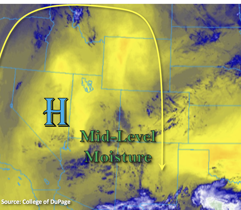
High temperatures will be on the rise today with the strengthening ridge overhead. As far as the first ingredient for rainfall, there’s a bit of mid-level moisture rotating around the High (mostly over the four-corners region). Average PW for that area was measured around 0.50 inches, which is plenty for scattered storms to develop this afternoon. Over Denver, PW was slightly higher at 0.58 inches, but a dry mid-level atmosphere was noted. For lift, there’s some weak mid-level energy moving around the High from north to south. Those weak disturbances and the daily diurnal flow will provide the lift for storm development over the mountains. Finally, instability looks to be decent over the central and southern mountains as well as over the eastern plains. However, NNE steering flow and lack of lift over the plains means that the scattered storms this afternoon and evening should be confined to the central and southern mountains. Further north (Front Range/Central Mountains), that dry air in the mid-levels should keep storms confined to areas along and close to the Continental Divide.
Morning soundings (south) indicated that the majority of the moisture today is located in the mid-levels. This and inverted-V profiles with decent CAPE imply that the main threat from storms that develop this afternoon and evening will be strong outflow winds. Accompanying those stronger, scattered storms that develop will be lightning, small hail and brief, heavy rainfall. Storms should dissipate quickly with the decreasing instability after the sun sets. Flooding is NOT forecast today.
Today’s Flood Threat Map
For more information on today’s flood threat, see the map below. If there is a threat, hover over the threat areas for more details, and click on burn areas to learn more about them. For Zone-Specific forecasts, scroll below the threat map.

Zone-Specific Forecasts:
Central Mountains, Southeast Mountains, San Juan Mountains, Front Range & San Luis Valley:
Scattered storms will develop this afternoon over the mountains favoring areas south for more widespread development. Best coverage for scattered storms will be over the San Juan Mountains. The main threat from storms that develop south will be strong outflow winds, lightning, small hail and brief rainfall. Max 1-hour rain rates up to 0.50 inches (San Juans), 0.25 inches (Southeast Mountains) and 0.20 inches (Front Range and Central Mountains) will be possible. With NNE steering flow, some storms may wander into the SLV, but should dissipate rather quickly due to the dry surface layer. Flooding is NOT forecast today.
Primetime: Noon to 10PM
Southwest Slope, Northwest Slope, Northern Mountains & Grand Valley:
It’s going to be hot and dry today. Afternoon highs over the Grand Valley will reach into the mid-90Fs. With upper 80Fs and low 90Fs for the lower elevations of the Southwest and Northwest Slopes. Over the Northern Mountains, valleys should reach around 80F this afternoon. Rainfall is not forecast.
Southeast Plains, Raton Ridge, Palmer Ridge, Northeast Plains & Urban Corridor:
High temperatures this afternoon will craw into the upper 80Fs with slightly lower temperatures for the elevated Ridges. There may be a few clouds this afternoon, but mainly looking at clear, blue skies. Rainfall is not forecast.