Issue Date: Wednesday, June 2, 2021
Issue Time: 10:15 am MDT
Summary
Storms began to develop over high elevations in the late morning and early afternoon yesterday, before making their way eastward and tapping into additional available moisture. Several severe thunderstorms warnings were issued for the Eastern Plains. The largest threats from these storms were localized heavy rainfall and large hail, including a 1.75 inch hail report in Fort Morgan in Morgan County. Tuesday also marked the 4th day in a row in which a funnel cloud or tornado was reported in Colorado, this time in Bethune in Kit Carson County. For rainfall estimates in your area, check out the State Precipitation Map at the bottom of today’s post.
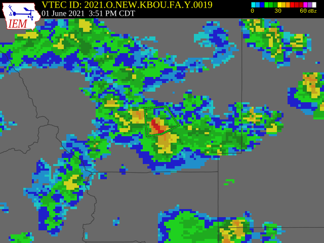
As seen in the Fire Burn Forecast, flooding was reported over the Cameron Peak burn scar yesterday. A flood advisory was issued in Larimer County for the Cameron Peak burn scar at 2:51 pm after Doppler radar indicated heavy rain from thunderstorms, which is seen in the area of higher (red) reflectivity in the warning polygon in the map below (note the time on the map is Central Daylight Time). Around this time, a CoCoRaHS observer in Drake, at the southeast edge of the burn scar, reported high intensity rainfall and ash and debris movement consistent with burn scar flooding. Their full comment is below:
“Heavy rain and hail produced .39″ in the rain gauge during a 25 minute window between 2:35PM and 3:00PM. Ash and debris movement from Cameron Peak Fire caused a culvert in our driveway to plug up with sand and consequently overflow and washout our driveway. There is a 3′ basin to capture water before the culvert. It was clear prior to the storm except for a small pile of pine needles in the ditch that I hadn’t cleaned out. The 3′ basin is now filled with ash, sand, rocks and pine needles. The driveway is covered in pine needles as well.”
Click Here For Map Overview
Note: The 24-hour, 48-hour and 72-hour total precipitation do not contain bias corrections today. This means there may be underestimations in QPE over the southwest and southeast corners of the state.

