Issue Date: Monday, June 1, 2021
Issue Time: 9:45AM MDT
— Flooding is NOT expected today
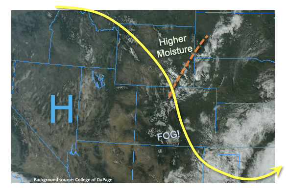
As shown in the visible satellite image, below, the trough responsible for a long period of unsettled weather for Colorado is finally moving east. A strong ridge, currently centered over the Great Basin, is itching to move into its place. However, before that occurs, another disturbance will ripple through the northwesterly flow aloft today, providing scattered showers and thunderstorms mainly over eastern Colorado. This morning’s PW at Denver and Grand Junction was 0.34 and 0.40 inches, respectively. While this is certainly nothing to write home about, there was actually notably moister air to the north in association with the aforementioned disturbance. Thus, PW will rebound into the 0.6-0.9 inch range east of the Continental Divide this afternoon. This, coupled with the strong morning heating, will cause showers and storms that are capable of short-term heavy rainfall but not much more. With a strong increase in northerly steering winds aloft, to the tune of 40mph+, storm motion will be too quick to warrant a flood threat. However, severe weather in the form of large hail and damaging winds, will be possible with the strongest storms this afternoon over eastern Colorado. Flooding is NOT expected today.
Today’s Flood Threat Map
For more information on today’s flood threat, see the map below. If there is a threat, hover over the threat areas for more details, and click on burn areas to learn more about them. For Zone-Specific forecasts, scroll below the threat map.

Zone-Specific Forecasts:
Northeast Plains, Southeast Plains:
Much warmer with scattered to numerous showers and thunderstorms this afternoon. Large hail and damaging winds will be possible with the strongest storms. Max 1-hour rainfall up to 1.4 inches possible, locally, especially along the KS border. However, flooding is NOT expected today. Note that storms could continue into the late evening hours along the KS and OK borders.
Primetime: 12PM through 12AM
Palmer Ridge, Raton Ridge, Urban Corridor, Front Range, San Luis Valley, Southeast Mountains:
Much warmer with scattered showers and weak thunderstorms this afternoon. Large hail and damaging winds will be possible over eastern areas. Max 1-hour rainfall up to 0.7 inches. Flooding is NOT expected today.
Primetime: 12PM through 7PM
Grand Valley, Southwest Slope, San Juan Mountains, Central Mountains, Northern Mountains and Northwest Slope:
Partly cloudy and pleasant today with isolated to widely scattered showers and storms possible this afternoon, mainly over the higher terrain. Max 1-hour rainfall up to 0.4 inches. Flooding is NOT expected today.
Primetime: 12PM through 6PM