Issue Date: Sunday, May 30th, 2021
Issue Time: 10:35AM MDT
— A MODERATE flood threat has been issued for portions of the Palmer Ridge, Southeast Mountains, western Southeast Plains and Raton Ridge
— A LOW flood threat has been issued for portions of the Northeast Plains, southern Urban Corridor and eastern Southeast Plains
A few showers over the Northern Mountains and Front Range to start the day with some thunder over the eastern plains. Today, the atmosphere will remain very moist over eastern Colorado, which is shown by the nearly saturated atmosphere in this morning’s sounding. PW was measured at 0.83 inches, which is well above normal for this time of year. One limiting factor for heavy rainfall over eastern Colorado will be lack of instability due to cooler temperatures and ongoing cloud cover (see visible satellite imagery below). This should somewhat help to temper the rain rates within the storms that develop on the north side of the front (southern Palmer Ridge). On the flip side, slow westward moving storms, a second round of widespread rainfall this afternoon/evening associated with the incoming trough (orange line below) and nearly continuous upslope flow will help increase rainfall accumulation for this area. This is especially true over the eastern plains where even higher moisture resides, so a Low flood threat has been issued for this area.
Stronger storms are forecast to develop along and south of the frontal boundary where better instability will be able to build. The highest rain rates should be over these regions and a couple severe storms are possible over the Raton Ridge, Southeast Plains and southern Palmer Ridge. Paired with slow storm motion, a Moderate flood threat has been issued. Threats include road, low-lying area and local stream flooding.
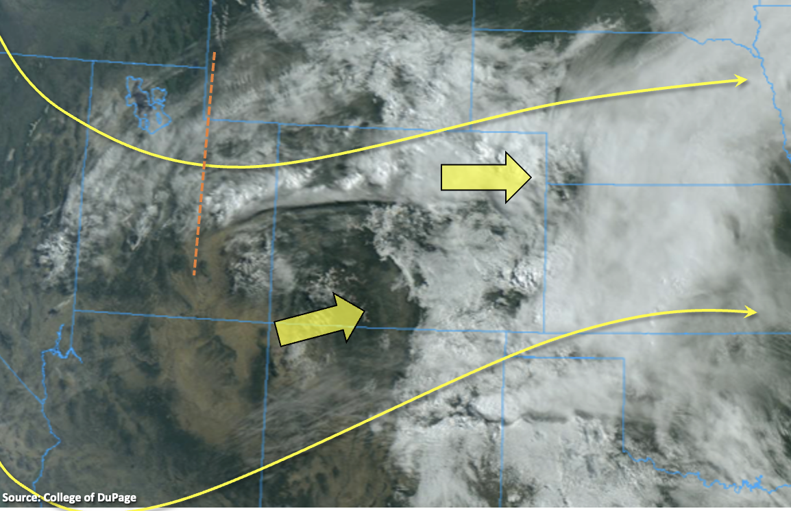
It’s a bit drier back to the west, especially over the southwest corner. PW at Grand Junction was measured at 0.48 inches, and a dry surface layer with a large dew point depression means storms that develop this afternoon will be less efficient at rainfall accumulation. Best chance for rainfall will be over the Central and Northern Mountains and over the lower elevations along and north of I-70.
Today’s Flood Threat Map
For more information on today’s flood threat, see the map below. If there is a threat, hover over the threat areas for more details, and click on burn areas to learn more about them. For Zone-Specific forecasts, scroll below the threat map.
A NWS Flood Warning is ongoing for the Purgatoire River at Las Animas through Sunday evening. As of 8AM the river was at 9.83 feet, which is in the Minor flood stage. Flood threats include minor agriculture flooding of low-lying areas near the river. Update: As of 10:30AM this morning, the river was at 13.81 feet, which is now in the Moderate flood stage. Flood threats continue to remain the same but are slightly elevated.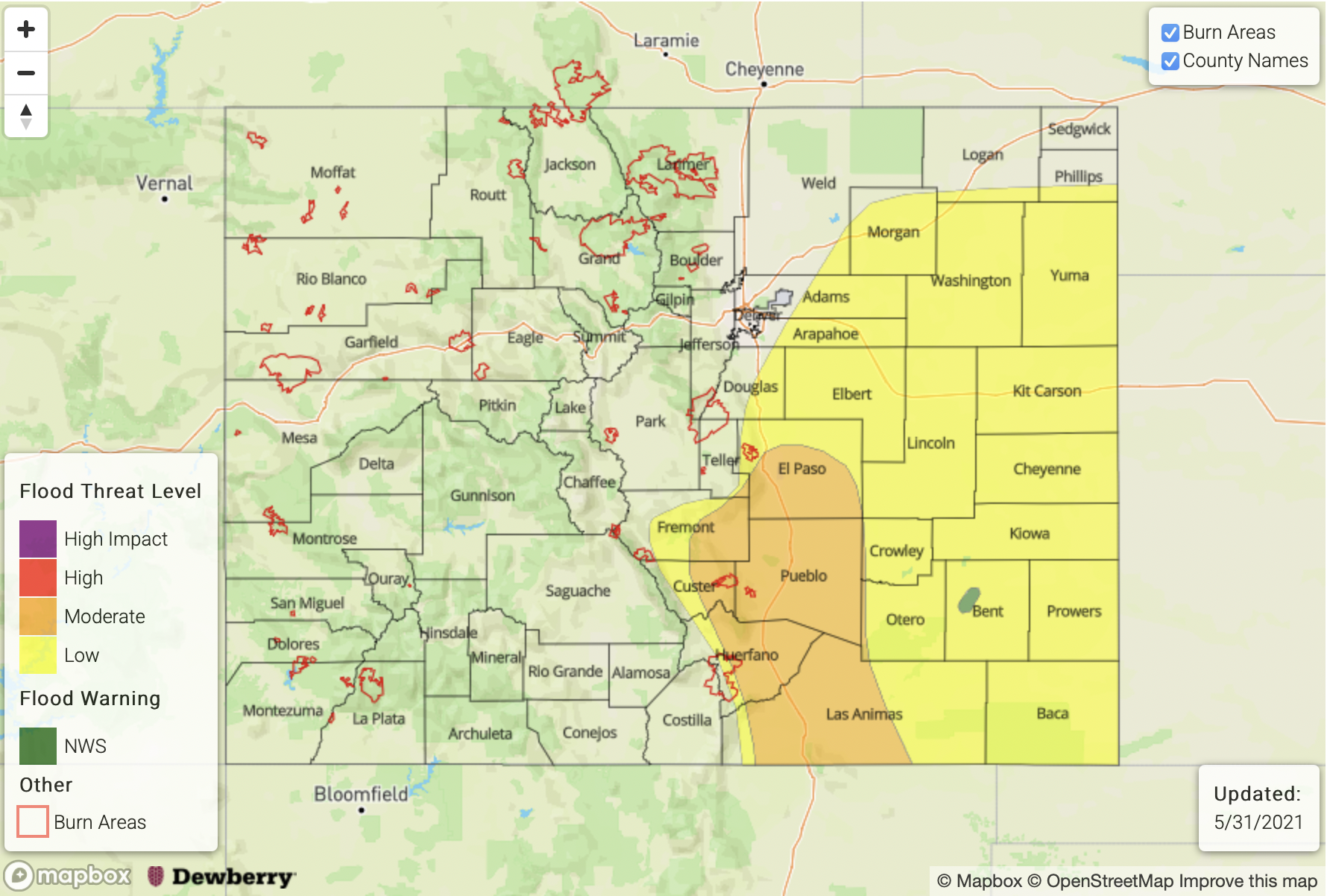
Zone-Specific Forecasts:
Southeast Plains, Raton Ridge & Palmer Ridge:
There’s a chance for a couple severe storms over these regions this afternoon (south) if some instability is able to build before the storms move slowly off the mountains. Severe storms that develop south, may produce 1.50 inch hail and brief windy conditions. As the storms move into a higher moisture environment at the lower elevations, max 1-hour rain rates up to 2 inches will be possible with widespread rainfall forecast. Thus, a Moderate flood threat has been issued for road, low-lying area and local stream flooding.
Primetime: 1PM to Midnight
Front Range, Urban Corridor, Northeast Plains & Southeast Mountains:
Limited instability further north should limit rainfall rates, although after this morning’s rainfall and another round this afternoon could push accumulations over the Front Range close to 1.25 inches by morning. Over the Southeast Mountains, general rainfall totals should be closer to 0.75 inches with light showers linger into the night. With slightly higher moisture over the eastern plains and nearly stationary storms, totals are expected to be larger over the 24-hour period. With isolated 24-hour totals up to 3.25 inches possible over plains, the Low flood threat has been extended out east. Flooding of roads, ditches, fields and low-lying areas is possible.
A Flash Flood Watch has been issued by NWS Pueblo for the burn areas over the Southeast Mountains. Please check our FBF for burn areas today as there has been elevated threats issued for some burn areas within these regions.
Primetime: Ongoing to 2AM
Northwest Slope, Northern Mountains, Grand Valley, Central Mountains, San Juan Mountains, Southwest Slope & San Luis Valley:
Best chance for a couple thunderstorms and accumulating showers will be over the Central and Northern Mountains. Some scattered storms forecast for the elevated plateaus late this afternoon and evening along and north of I-70. Max 1-hour rain rates up to 0.25 inches will be possible with isolated storm totals up to 0.50 inches possible on southwest facing slopes. Flooding is NOT forecast.
Primetime: 2PM to 11PM