Issue Date: Saturday, May 29th, 2021
Issue Time: 10:00AM MDT
— A MODERATE flood threat has been issued for parts of the Northeast Plains and Southeast Plains
— A LOW flood threat has been issued for parts of the Urban Corridor and Palmer Ridge
— The threat will persist later that normal, into the late evening and overnight hours (especially further east)
— A MODERATE flood threat has been issued for the Calwood and Cameron Peak burn scars (see Fire Burn Forecast page for more info)
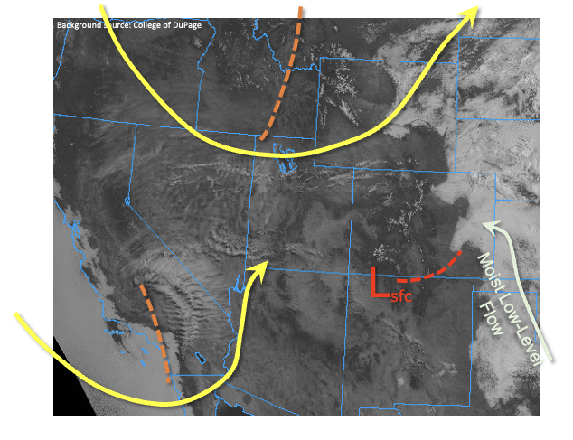
As expected, a complex weather pattern is beginning to take shape over Colorado, in response to two forcing features as shown in the visible image below. The first feature is a trough in the northern jet stream, currently entering western Wyoming. This will provide synoptic-scale lift mainly east of the Continental Divide beginning later this afternoon. To the south, a cut-off disturbance entering the southwest US coast will mainly affect Colorado beginning tomorrow, but will help anchor a developing surface low pressure over the CO/NM border today. PW this morning at Denver and Grand Junction was 0.48 and 0.41 inches, respectively. While this is certainly far from impressive, the developing surface low pressure will support a notable feed of low-level moisture from the southern Great Plains into eastern Colorado later today. PW is expected to jump to the 0.7-1.1 inch range east of the Continental Divide, which will be supportive of heavy rainfall.
The visible satellite image also shows that parts of eastern Colorado are currently seeing a thick low-cloud deck along with patchy dense fog. The rate at which this dissipates will be essential to determining where the strongest instability will develop. Currently it appears that the far northeast portion of the state will stay within this cool stable air for most of the day, limiting chances for heavy rainfall.
In summary, we expect late morning and afternoon shower and thunderstorms to form off the higher terrain and quickly grow in coverage and rain intensity. A Low flood threat has been posted for parts of the Urban Corridor and Palmer ridge for the risk of isolated flash flooding. Nuisance street and field flooding will also accompany this threat. Severe weather, notably large hail but also isolated tornadoes will also be possible, especially with the afternoon activity. Further east, a couple of areas of Moderate threat have been posted in anticipation of the late afternoon and evening surge of moisture into the area. Also note that the threat will persist later than normal today, well into the evening and overnight hours.
Today’s Flood Threat Map
For more information on today’s flood threat, see the map below. If there is a threat, hover over the threat areas for more details, and click on burn areas to learn more about them. For Zone-Specific forecasts, scroll below the threat map.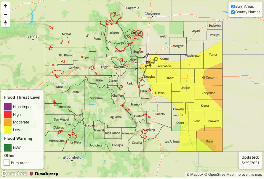
Zone-Specific Forecasts:
Northeast Plains, Southeast Plains:
Scattered showers and thunderstorms later this morning becoming more widespread through the afternoon, evening and overnight hours. Max 1-hour rain rates up to 2.3 inches, with max 3-hour rainfall up to 3.7 inches warrant a Low/Moderate flood threat for the risk of isolated flash flooding. Street and field flooding will also be likely with the heaviest rainfall. The threat will continue well into the overnight hours.
Primetime: 1PM through 4AM
Palmer Ridge, Raton Ridge, Urban Corridor, Front Range:
Scattered showers and thunderstorms later this morning becoming more widespread through the afternoon, evening and early overnight hours. Max 1-hour rain rates up to 1.1 inches, with max 3-hour rainfall up to 2.0 inches warrant a Low flood threat for the risk of isolated flash flooding, debris slides and mud flows. Street and field flooding will also be likely with the heaviest rainfall. The threat will continue well into the overnight hours.
Primetime: 1PM through 12AM
Grand Valley, Southwest Slope, San Luis Valley, Southeast Mountains, San Juan Mountains, Central Mountains, Northern Mountains and Northwest Slope:
Partly cloudy and cooler with isolated to scattered showers and a weak thunderstorm possible especially for northern areas. Flooding is NOT expected today.
Primetime: 12PM through 6PM