Issue Date: Tuesday, May 25, 2021
Issue Time: 10:15 am MDT
Summary
Isolated thunderstorms on the Eastern Plains brought significant precipitation to the towns of Burlington and Holly yesterday evening and overnight, though most of the really heavy rainfall occurred on the Kansas side of the state border. 1.20 inches was recorded by CoCoRaHS observers in Burlington, and according to their notes most of that precipitation fell in just 25 minutes overnight, along with pea-sized hail. Flood warnings were issued by the Pueblo and Goodland, KS WFOs for both cells after Doppler radar indicated heavy rainfall, and minor flooding was reported in Burlington. The day was calm and dry for the rest of Colorado. For rainfall estimates in your area, check out our State Precipitation Map below.
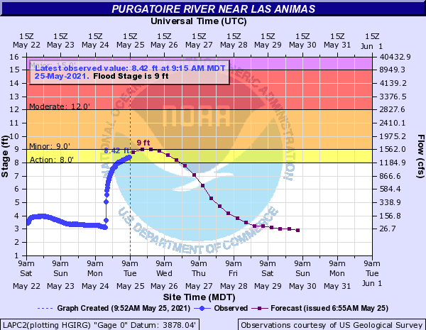
The Purgatoire River near Las Animas is currently in an “Action” stage, or near flood levels, as seen in the hydrograph below. Many gauges along the Arkansas River and its tributaries (including the Purgatoire) are at or above normal streamflow for this time of year. Gauges across the state will be recording their peak streamflow for the year in the coming weeks, thanks to snowmelt runoff and additional spring rain.
Click Here For Map Overview
Note: The 24-hour, 48-hour and 72-hour total precipitation do not contain bias corrections today due to errors in the CoCoRaHS data. This means there may be underestimations in QPE over the southwest and southeast corners of the state.

