Issue Date: Monday, May 24th, 2021
Issue Time: 9:35AM MDT
— Flooding is NOT expected today
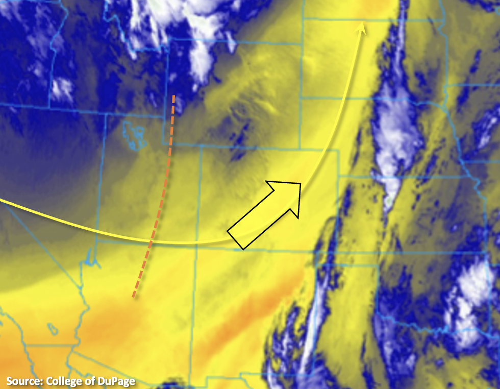
The dry air that was over western Colorado yesterday has been entrained into the eastern portion of the state with the continued southwesterly flow aloft. This can be seen by the shades of yellow over the state in the water vapor imagery below. PW at Grand Junction was measured at 0.27 inches, and over Denver PW has dropped to 0.23 inches. The remaining energy from the trough that brought storms to Colorado the last couple of days will move through the state today (orange line in Utah). With a dry and stable airmass in place, only a few fair weather cumulus are expected this afternoon over the high terrains. So, the forecast is plenty of sunshine statewide with temperatures over the eastern portion of the state similar to yesterday and a slight cool down over the western half of Colorado.
Late tonight, there is a chance for some thunderstorms over the central, eastern border counties. It is likely that moist outflow boundaries from storms over KS will push back west across the border with low-level moisture also being reinforced on the north side of a surface low. This moisture could mix with a low-level jet (left exit) and mid-level energy to produce an isolated line of thunderstorms. Although storms would be isolated in nature, nearly stationary movement could produce brief local, heavy rainfall. At this time, it does not appear that flood threat thresholds will be met, but if necessary, a PM update will be issued. Flooding is not forecast.
Today’s Flood Threat Map
For more information on today’s flood threat, see the map below. If there is a threat, hover over the threat areas for more details, and click on burn areas to learn more about them. For Zone-Specific forecasts, scroll below the threat map.
Zone-Specific Forecasts:
Southeast Plains, Northeast Plains & Palmer Ridge:
Clear conditions are forecast today with highs in the 80Fs (south) and 70Fs (north/west). Overnight, a line of thunderstorms may develop along the eastern border where high moisture and favorable dynamics will be in place. Although brief, heavy local rainfall will be possible with the nearly stationary storms, instability looks to be a limiting factor for widespread heavy rainfall. Isolated rainfall totals up to 1.25 inches will be possible. If the flood threat increases throughout the day, a PM update will be issued.
A Flood Watch has been issued for the Purgatoire River near Las Animas from Tuesday evening to Wednesday afternoon. Action stage was reached at the Arkansas River at La Junta gauge on Sunday (high flows had retreated here as of 9AM).
Primetime: 11PM to 5AM
Raton Ridge, Front Range, Southeast Mountains, San Luis Valley & Urban Corridor:
Plenty of sunshine with a few fair weather cumulus forecast over the mountains this afternoon. Although there is plenty of fog this morning, this should burn off rather quickly with the mixing out of the shallow surface moisture. Stable conditions and the dry air mass will keep rainfall out of the forecast today. Highs are forecast to be in the 80Fs (south), 70Fs for the Urban Corridor and 60Fs for the mountain valleys. Rainfall is not forecast.
San Juan Mountains, Central Mountains, Northern Mountains, Northwest Slope, Grand Valley & Southwest Slope:
Cold start to the morning, but clear skies and plenty of sunshine will help warm up the temperatures. Highs today are forecast in the 70Fs for the lower elevations and valleys. Over the mountain valleys, temperatures are forecast to be in the 60Fs. Rainfall is not forecast today.