Issue Date: Tuesday, May 18th, 2021
Issue Time: 9:50AM MDT
— A MODERATE flood threat has been issued for parts of the Raton Ridge
— A LOW flood threat has been issued for parts of the Palmer Ridge, Southeast Plains and Southeast Mountains
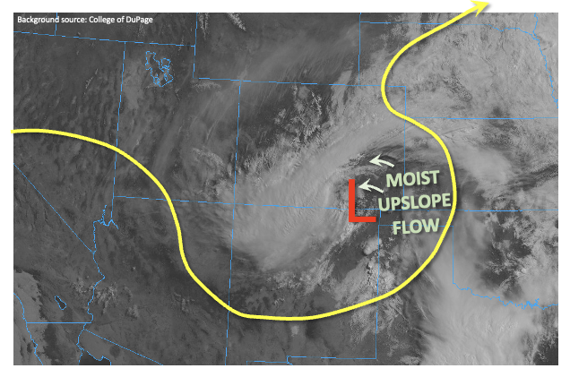
This morning’s visible imagery, below, shows that the slow-moving, cut-off upper-level low pressure has finally made it into the state. A clear surface low is noted this morning over the CO/NM border. Many metrics related to heavy rainfall potential have decreased markedly since yesterday morning. For example, instability will be limited to the southeast quadrant of the state today. Mid-level lapse rates have fallen substantially, which also places a bit of a constraint on moisture convergence, and thus high-end rainfall rates. Moisture has also generally decreased with Denver’s PW dropping from 0.76 to 0.56 inches. Although Grand Junction’s has increased from 0.40 inches to 0.61, boundary layer moisture is still lacking for heavy rainfall activity west of the Continental Divide. Lastly, cooler temperatures will lower the snow line to below 9,000-10,000 feet, further decreasing the concern of excessive runoff.
However, over the Raton Ridge and surrounding areas, the combination of strong daytime heating (see clearing on visible satellite image), deep, moist, upslope flow and relatively slow steering winds will contribute to a Moderate/Low flood threat. A very small corridor of Moderate flood threat has been issued on the eastern face of the Wet Mountains, where antecedent rainfall above 2 inches will cause very effective runoff of any new rainfall. Isolated flash flooding will be possible today in the threat areas. Additionally, an elevated concern for mud flows and debris slides in steeper terrain will persist through the day and into the evening, as these processes can often show a delayed response to long duration heavy precipitation.
Today’s Flood Threat Map
For more information on today’s flood threat, see the map below. If there is a threat, hover over the threat areas for more details, and click on burn areas to learn more about them. For Zone-Specific forecasts, scroll below the threat map.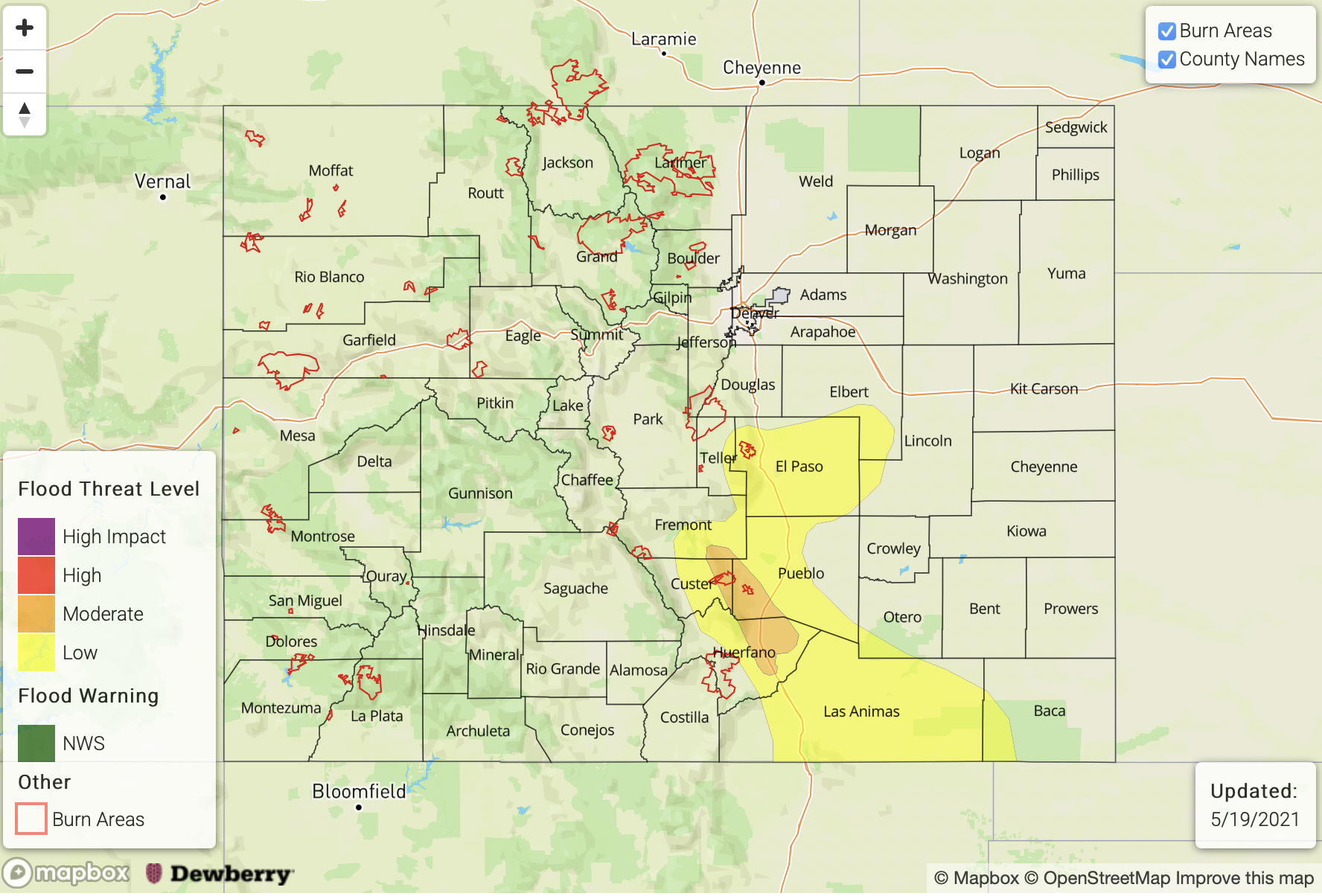
Zone-Specific Forecasts:
Raton Ridge, Southeast Plains, Southeast Mountains and Palmer Ridge:
Much cooler today with widespread showers and thunderstorms, increasing in coverage and intensity through the afternoon. Max 1-hour rainfall up to 1.2 inches will be possible, with max 3-hour rainfall up to 2.1 inches. The juxtaposition of the new rainfall with yesterday’s high amounts warrants a narrow Moderate flood threat for the eastern face of the Wet Mountains. Elsewhere, a Low flood threat has been issued. A severe storm or two is possible along the KS, OK and NM borders with the primary threat being large hail.
Rainfall intensity will subside this evening, but the threat of mud flows and debris slides will persist into the night.
Primetime: Now through 6AM, with highest rainfall intensity between 12PM and 7PM
Northern Mountains, Front Range, Urban Corridor, Central Mountains and Northeast Plains, San Juan Mountains and San Luis Valley:
Cooler and variable cloudiness with scattered showers and a weak thunderstorm possible in the afternoon and evening. Max 1-hour rainfall up to 0.8 inches eastern areas and 0.5 inches in western areas. However, flooding is NOT expected today.
Grand Valley, Southwest Slope and Northwest Slope:
Partly cloudy and cooler with isolated showers, and perhaps a weak thunderstorm possible this afternoon. Max 1-hour rainfall up to 0.3 inches. Flooding is NOT expected today.