Issue Date: Monday, May 17th, 2021
Issue Time: 10:15AM MDT
PM Update (4PM): Heavy rainfall is occurring over the Southeast Mountains and eastern Raton Ridge with a couple gauges already recording 1 inch. With rainfall forecast to continue for the next 3-5 hours, the Moderate threat has been pulled back to the Southeast Mountains and Raton Ridge. Tonight’s heavy rainfall threat has also been pulled back into the western Southeast Plains (Pueblo, Crowley and Otero Counties). Along the eastern border, Kiowa, Bent and northern Prowers will continue to be under the Moderate flood threat due to the potential for increased runoff from any storms that develop in that area.
— A MODERATE flood threat has been issued for portions of the Palmer Ridge and Southeast Plains
— A LOW flood threat has been issued for the Front Range, Raton Ridge, Southeast Mountains, Palmer Ridge and portions of the Central Mountains and Northeast Plains
It’s a warm and nearly sunny start to the day over western Colorado, and a cool and cloudy start to the day over eastern Colorado. The upper-level Low is currently over the Desert Southwest and will track eastward throughout the day helping to produce counter-clockwise winds. Moisture wrapped around this Low, mid-level lift in front of it and persistent upslope flow will produce widespread storms over the mountains this afternoon and evening. With weak steering flows once again and storms pulsing in intensity (embedded convection), decent accumulations are forecast. A Low flood threat has been issued for the Front Range and Southeast Mountains where 1 to 2 hour totals up to 1.50 inches are possible, which could cause local flooding issues.
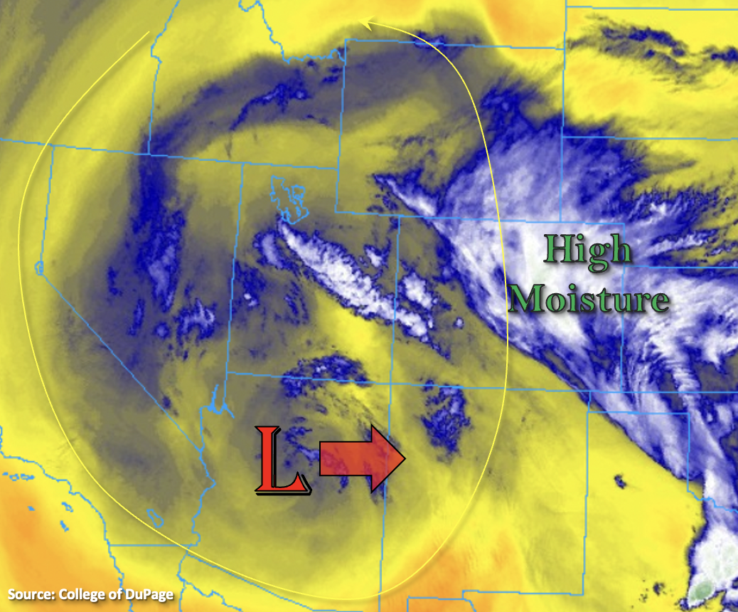
The upslope component over eastern Colorado will help reinforce the moisture already in place, and PW this morning at Denver increased to 0.76 inches. This is about as high as it gets for mid-May, so it’s juicy out there. Lift out in front of the Low as it moves eastward will help produce additional storm activity over the adjacent eastern plains and Southeast Plains. Stronger instability will be able to build over the Raton Ridge and far eastern Plains, so a couple severe storms may develop with the main threats being hail and outflow winds. Finally, a local vorticity maximum over the Northeast Plains and plenty of outflow boundaries from the last couple days will help produce a third set of storms over this region. Similar to the last couple of days, heavy rainfall is anticipated with the thunderstorms that develop over the eastern plains. Thus, a Moderate/Low flood threat has been issued.
Today’s Flood Threat Map
For more information on today’s flood threat, see the map below. If there is a threat, hover over the threat areas for more details, and click on burn areas to learn more about them. For Zone-Specific forecasts, scroll below the threat map.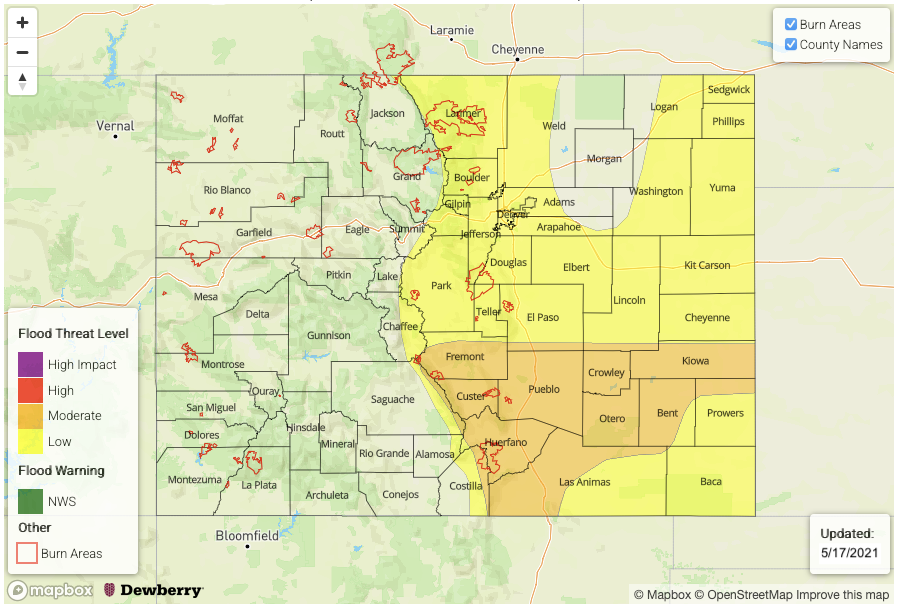
Zone-Specific Forecasts:
Southeast Plains, Northeast Plains, Raton Ridge & Palmer Ridge:
Expect slow northeast movement of the storms as the Low traverses east. A couple severe storms are possible this afternoon with the main threats being severe hail and strong outflow winds. Heavy local rainfall is possible late this afternoon, evening and overnight with the high moisture and slow steering flow, and isolated totals up to 3 inches will be possible once again. Some of these regions have received quite a bit of rainfall over the last couple of days. With saturated soils, if rainfall tracks over the same area, field ponding, road flooding and excessive rainfall is possible. A Low/Moderate flood threat has been issued. Expect rainfall to linger into tomorrow morning.
Primetime: Noon to Ongoing
Front Range, Southeast Mountains & Urban Corridor:
A Low flood threat has been issued for these zones due to the consistent upslope flow generating multiple rounds of rainfall. Just enough daytime heating could help produce some embedded convection within the widespread rainfall. One to three hour totals could reach up to 1.50 inches, which could cause some local flooding issues. Expect storms to move into the Urban Corridor by late afternoon. The intensity of these storms is still a bit unknown due to the cloud cover. Similar to yesterday, if the sun can poke through, max 1-hour rain rates up to 1.10 inches per hour will be possible. Thus, the Low flood threat has been issued.
Primetime: 4PM to 11PM
Northwest Slope, Northern Mountains, Grand Valley, Central Mountains, San Juan Mountains, Southwest Slope & San Luis Valley:
Finally, some wetting rainfall for the high terrains this afternoon. Small hail and brief outflow winds will be possible with the stronger thunderstorms that develop. Max 1-hour rain rates up to 0.75 inches per hour (Central Mountains) and 0.50 inches will be possible (Northern/San Juan Mountains). Best chance for accumulations will be over the Central Mountains with more spotty totals around 0.5 inches for the other mountain ranges. Portions of the San Luis Valley could receive up to 0.30 inches. Shower activity should begin to end a couple hours after sundown as instability decreases.
Primetime: 1PM to 10PM