Issue Date: Sunday, May 16th, 2021
Issue Time: 9:45AM MDT
PM update (5:15 PM): Lack of daytime heating due to today’s cloud cover has decreased the flood threat across the Urban Corridor. The heavy rainfall forecast for the eastern plains looks to be on track, although totals will likely be slightly lower than guidance hinted at this morning. Nonetheless, persistent and heavy rainfall is expected to cause flooding issues.
— A MODERATE flood threat has been issued for portions of the Palmer Ridge, Northeast Plains and Southeast Plains
— A LOW flood threat has been issued for the Urban Corridor and portions of the Front Range
Plenty of moisture remains over the eastern portion of the state this morning. Dew points are being measured in the upper 40Fs and 50Fs, and PW was measured at 0.60 inches in Denver and 1.15 inches at North Platte (NE). Visible satellite below indicates fog over the Northeast Plains and cloud cover pushing in from our north (green arrow). As this boundary pushes south (marked by the cloud cover), it looks to stall out and will likely support and anchor heavy rainfall over the eastern plains this afternoon and evening. The environment to the north of this boundary (northeast corner) will likely be capped, which means heavy rainfall chances are limited unless there are some breaks in the cloud cover.
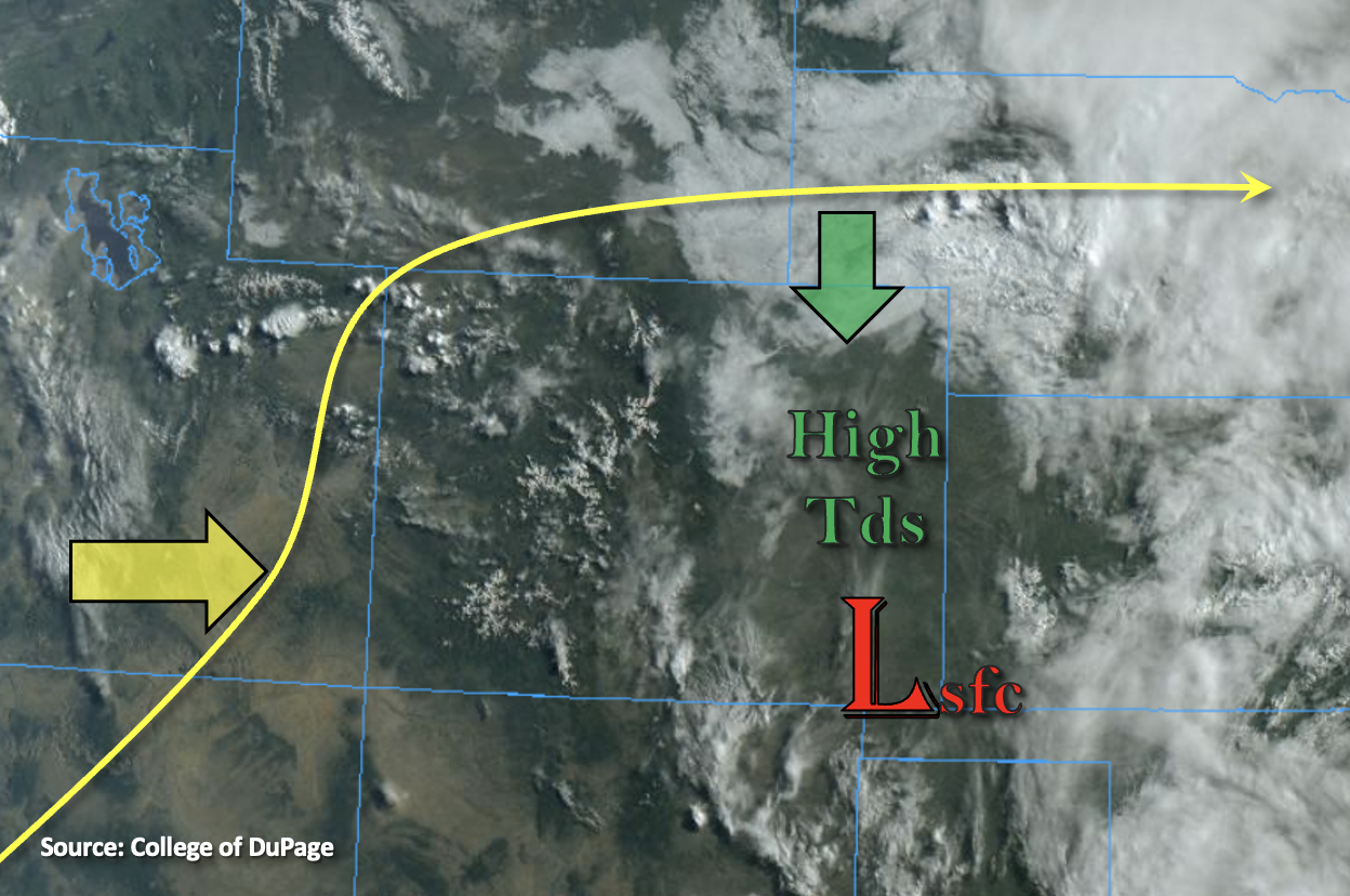
Weak mid-level energy will continue to move through the flow as the cutoff low approaches the four corners region. This will help spark numerous storms over the elevated Ridges and Front Range by mid-afternoon. Slow westerly steering flows are forecast once again, so the last big ingredient needed for heavy rainfall is instability. This should be no problem over the eastern plains where there already is plenty of sunshine. Thus, a Moderate flood threat has been issued for this area with increased lift coming later this evening. However, back along the Urban Corridor and Front Range, there needs to be some breaks in the cloud cover throughout this day for instability to build. If this occurs, thunderstorms that develop will be capable of producing very heavy rainfall over a 1 to 2 hour period. Thus, a Low flood threat has been issued over this area.
Over western Colorado, the approaching trough and slight increase in moisture will help produce weak storms over the high terrains. Best chance for accumulation will be along and near the Continental Divide; however, accumulations will be minimal.
Today’s Flood Threat Map
For more information on today’s flood threat, see the map below. If there is a threat, hover over the threat areas for more details, and click on burn areas to learn more about them. For Zone-Specific forecasts, scroll below the threat map.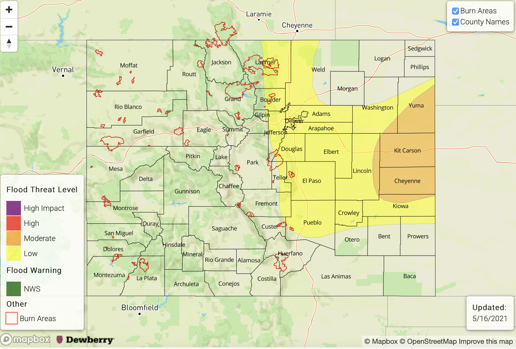
Zone-Specific Forecasts:
Southeast Plains, Northeast Plains & Palmer Ridge:
A Moderate flood threat has been issued for this region. Slow steering winds, high moisture and increased lift over the area will come together this afternoon and evening for widespread thunderstorm development. Isolated rainfall totals up to 3.75 inches will be possible with more general storm core totals between 2 and 2.5 inches. This could cause road flooding, field ponding and local stream flooding, and additional rainfall is likely over areas that already received a lot of precipitation yesterday. A couple severe storms will be possible with the main threats being severe hail and strong outflow winds, although a weak tornado cannot be ruled out.
Primetime: 5PM to 3AM
Front Range, Southeast Mountains, Raton Ridge & Urban Corridor:
A Low flood threat has been issued for portions of these regions. Rainfall is likely this afternoon over the Front Range with only light showers forecast for the foothills of the Southeast Mountains. Better chance for storms development (south) over the Raton Ridge where max 1-hour rain rates just under 1 inch will be possible. Further north, if instability is able to form with breaks in cloud cover, heavy rainfall will be possible as storms move slowly off the mountains and into the Urban Corridor. In this scenario, storm totals up to 2 inches will be possible, which would cause road, underpass and local stream flooding. Severe threat is lower today, but some small hail may be possible with the stronger storms that develop.
Primetime: 3PM to 10PM
Northwest Slope, Northern Mountains, Grand Valley, Central Mountains, San Juan Mountains, Southwest Slope & San Luis Valley:
There should be an increase in cloud cover this afternoon as the trough approaches. While moisture has increased some, dry lower levels continue. This means the main threat from storms that develop again today will be wind. Accumulations up to 0.10 inches will be possible for areas along and near the Continental Divide. Flooding is NOT forecast.