Issue Date: Tuesday, May 11, 2021
Issue Time: 10:00 am MDT
Summary
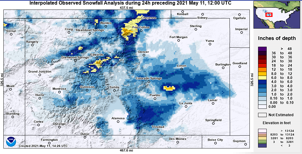
Heavy mountain snow and a chance for some snow/wintry precipitation at lower elevations was in the forecast, and that’s exactly what we got with this spring storm! Over a foot of new snow was recorded in the Northern Mountains, including 13.0” on Trail Ridge Road in Larimer Country. The below map from NOHRSC shows interpolated snowfall observations ending at 6:00 am this morning across the state. In addition to the Northern Mountains, centers of 8-12 inches of snow were also observed in the Central Mountains and along the Palmer Ridge. At lower elevations along the Front Range and Eastern Plains, there was widespread light snowfall, with some pockets up to 6 inches as well. Additional snowfall reports from the NWS are found in the table below as well.
When it wasn’t falling as snow, there was still plenty of rain accompanying this system. CoCoRaHS observers in Fort Collins recorded over an inch and half of liquid precipitation in just 24-hours, and there were similar liquid precipitation totals on the Southeastern Plains. Due to the long-duration and low-intensity nature of yesterday’s precipitation, flooding was not reported on Monday. For precipitation estimates in your area, check out our State Precipitation Map below.
5-11-2021 Snowfall
| wdt_ID | Observation Time | Location | Snow Depth (in.) |
|---|---|---|---|
| 1 | 03:00 am MDT - 5/11/2021 | 1 E TRAIL RIDGE, CO | 13 |
| 2 | 08:00 pm MDT - 5/10/2021 | 3 NNE MT AUDUBON, CO | 10 |
| 3 | 08:00 pm MDT - 5/10/2021 | BEAR LAKE, CO | 10 |
| 4 | 09:00 pm MDT - 5/10/2021 | 4 WSW TRAIL RIDGE, CO | 10 |
| 5 | 08:00 am MDT - 5/11/2021 | 1 ESE WARREN AF BASE, WY | 8.9 |
| 6 | 09:30 pm MDT - 5/10/2021 | ESTES PARK, CO | 8.8 |
| 7 | 03:00 am MDT - 5/11/2021 | 4 S LONG'S PEAK, CO | 8 |
| 8 | 09:00 pm MDT - 5/10/2021 | 1 NNW CAMERON PASS, CO | 8 |
| 9 | 07:00 am MDT - 5/11/2021 | 7 NNE LA VETA, CO | 8 |
| 10 | 08:30 am MDT - 5/11/2021 | 2 NNE CHEYENNE, WY | 7.5 |
| Observation Time | Location | Snow Depth (in.) |
Click Here For Map Overview
The map below shows radar-estimated, rainfall gage-adjusted Quantitative Precipitation Estimates (QPE) across Colorado. The map is updated daily during the operational season (May 1 – Sep 30) by 11AM. The following six layers are currently available: 24-hour, 48-hour and 72-hour total precipitation, as well as maximum 1-hour, 2-hour and 6-hour precipitation over the past 24 hour period (to estimate where flash flooding may have occurred). The accumulation ending time is 7AM of the date shown in the bottom right corner. Also shown optionally are vulnerable fire burn areas (post 2012), which are updated throughout the season to include new, vulnerable burn areas. The home button in the top left corner resets the map to the original zoom.

