Issue Date: Sunday, May 9, 2021
Issue Time: 10:30 am MDT
Summary
The state finally saw some more measurable and widespread precipitation yesterday, especially along the Urban Corridor and Northeast Plains. This was a result of some widespread thunderstorms associated with the low-pressure trough and cold front that pushed across the state yesterday. These storms did have severe potential, and five Severe Thunderstorm Warnings were issued for storms on the Eastern Plains. Flooding was not reported on Saturday, for rainfall estimates in your area, check out our State Precipitation Map below.
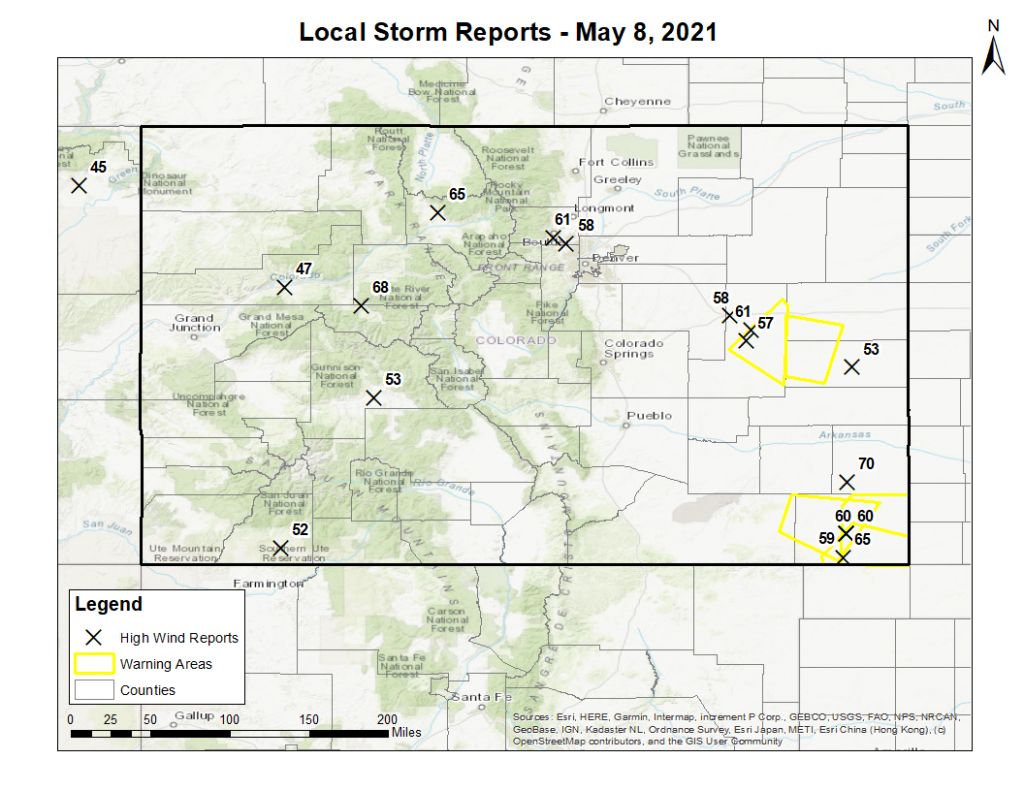
Along with the severe potential, yesterday was also another day with a number of high wind reports, this time from both non-thunderstorm and thunderstorm winds alike. Reports came in across the state, from Cortez in southwest, Boulder along the Front Range, and Springfield in the southeast. The highest wind report was 70 mph winds in Prowers County! The map below shows the locations of the high wind reports and their reported magnitude in miles per hour, as well as the Severe Thunderstorm Warning areas issued by the Goodland, KS, Boulder and Pueblo WFOs.
Click Here For Map Overview
The map below shows radar-estimated, rainfall gage-adjusted Quantitative Precipitation Estimates (QPE) across Colorado. The map is updated daily during the operational season (May 1 – Sep 30) by 11AM. The following six layers are currently available: 24-hour, 48-hour and 72-hour total precipitation, as well as maximum 1-hour, 2-hour and 6-hour precipitation over the past 24 hour period (to estimate where flash flooding may have occurred). The accumulation ending time is 7AM of the date shown in the bottom right corner. Also shown optionally are vulnerable fire burn areas (post 2012), which are updated throughout the season to include new, vulnerable burn areas. The home button in the top left corner resets the map to the original zoom.

