Issue Date: 7/23/2015
Issue Time: 9:41 AM
NO FLOOD THREAT IS FORECAST.
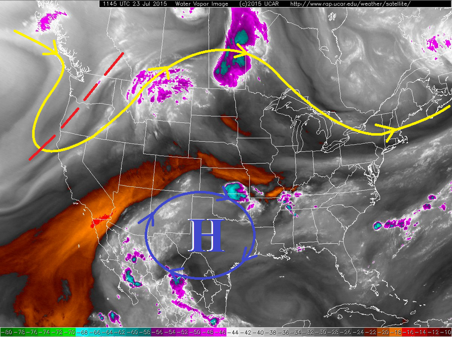
The overall pattern governing Colorado’s weather today will not change much over yesterday, but subtle shifts are apparent and will have effects on today’s forecast. If you take a look at the water vapor image below, and remember back to yesterday’s image, you’ll be able to pick out the features in the broad scale pattern that remain basically the same; the upper-level ridge across the central US, flanked by upper-level troughs on either coast.
The high pressure center denoted by the blue circle/arrows and blue “H” will build to the west/northwest, becoming centered over the TX/OK panhandles. This will keep west/southwest flow aloft in place across Colorado, which will continue to pump in drier, mid-level air for northern and northwest portions of Colorado, and reinforce the mid-level moisture across southern and southeastern Colorado.
Low-level moisture is lacking statewide, so the result of any mid-level moisture will be high-based thunderstorms, confined to over, and near, the higher terrain along and south of I-70. Heavy rain is not expected, so the main impacts will be dangerous cloud-to-ground lightning and gusty winds. Further east over the plains, today will be hot and dry as slight warming takes places aloft and caps off the environment. The exception to this will be along the CO/KS border; details are in the zone-specific forecast below. High temperatures will be a few degrees warmer than yesterday statewide.
Today’s Flood Threat Map
For more information on today’s flood threat, see the map below (hover over threat areas for more details). For Zone-Specific forecasts, jump below the map.

Zone-Specific Forecasts
Front Range north of I-70, Grand Valley, Northern Mountains, and Northwest Slope:
Mostly sunny and hot will be the main story today, as temperatures climb a few degrees over yesterday. A few fair weather clouds will develop this afternoon, but due to the dry air in place, no precipitation is expected.
Urban Corridor, Palmer Ridge, Northeast Plains, Southeast Plains, and Raton Ridge:
Mostly sunny and hot, with temperatures climbing into the upper 80s/low 90s across the Urban Corridor, Palmer Ridge, and Raton Ridge, with widespread mid-90s temperatures across the Plains. The Arkansas River Valley across the Southeast Plains will be the hot spot today, with temperatures reaching into the low 100s.
A thunderstorm or two will be possible near the interface with the Front Range south of I-70 and Southeast Mountains for the Urban Corridor, Southeast Plains and Raton Ridge regions. Westerly flow aloft will try and push an isolated, weak thunderstorm overhead. Gusty winds and lightning will be the main result, with very little precipitation expected. Rain rates will be less than 0.4 inches/hour.
Along the CO/KS border, there will be a slight opportunity for an isolated thunderstorm or two to develop this afternoon/evening. A surface trough will be present along the border, with sufficient low-level moisture pumping in from the southeast. It is entirely possible that the activity stays on the Kansas side of the border, but there remains a small chance that it occurs just inside the Colorado border. For that reason, it gets a mention in today’s forecast. Maximum rain rates for these storms will be 0.6-1.2 inches/hour.
Timing: 2 PM – 9 PM
Front Range south of I-70, Central Mountains, Southeast Mountains, San Luis Valley, Southwest Slope, and San Juan Mountains:
Isolated, high-based showers and weak thunderstorms will develop this afternoon and evening as strong daytime heating works with the available mid-level moisture. Due to lacking low-level moisture, precipitation will generally be light, and the main threats will be dangerous cloud-to-ground lightning and gusty winds. The best coverage will occur across the San Juan and Central Mountains. Maximum rain rates will be 0.15-0.3 inches/hour.
Timing: Noon – 8 PM