Issue Date: Saturday, May 8, 2021
Issue Time: 9:15 am MDT
Summary
Yesterday was another uneventful day in terms of precipitation across the state. A handful of CoCoRaHS stations picked up Trace – 0.2” of precipitation, and some high-elevation SNOTEL stations in the Northern, Central, and San Juan Mountains picked up an additional 0.1” of liquid precipitation. Flooding was not reported on Friday, for rainfall estimates in your area, check out our State Precipitation Map below.
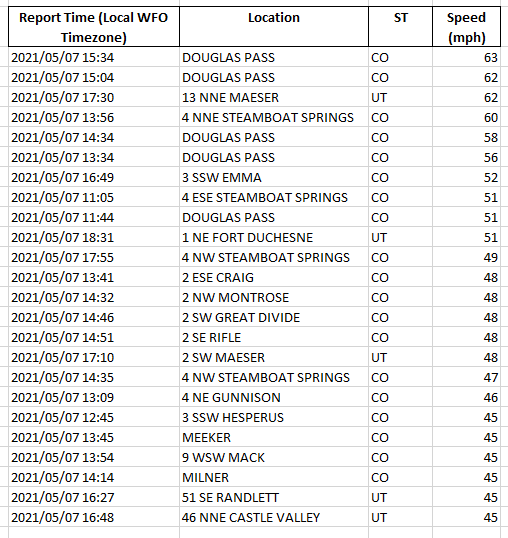
The real story of the day was non-thunderstorm high winds reported all along the Western Slope yesterday afternoon ahead of the approaching cold front. The table below shows the reports yesterday to the Grand Junction WFO, with wind gusts as high as 63 mph at Douglas Pass in Garfield County. This also marks the breakdown in the warm and dry pattern across the state for the past few days, ushering in cooler temperatures and a chance for much needed accumulating precipitation.
Click Here For Map Overview
The map below shows radar-estimated, rainfall gage-adjusted Quantitative Precipitation Estimates (QPE) across Colorado. The map is updated daily during the operational season (May 1 – Sep 30) by 11AM. The following six layers are currently available: 24-hour, 48-hour and 72-hour total precipitation, as well as maximum 1-hour, 2-hour and 6-hour precipitation over the past 24 hour period (to estimate where flash flooding may have occurred). The accumulation ending time is 7AM of the date shown in the bottom right corner. Also shown optionally are vulnerable fire burn areas (post 2012), which are updated throughout the season to include new, vulnerable burn areas. The home button in the top left corner resets the map to the original zoom.
