Issue Date: Monday, May 5, 2021
Issue Time: 9:15 am MDT
Summary
May 4, 2021 saw the passage of a shortwave trough across the state, which moved eastward from the northwest corner near the Wyoming/Utah borders. This fast-moving trough brought some localized rainfall to the state, but the main event was high winds. 52 mph winds were reported at the Craig-Moffat County Airport around 2:00 pm yesterday, with a few other high wind observations in nearby Routt County.
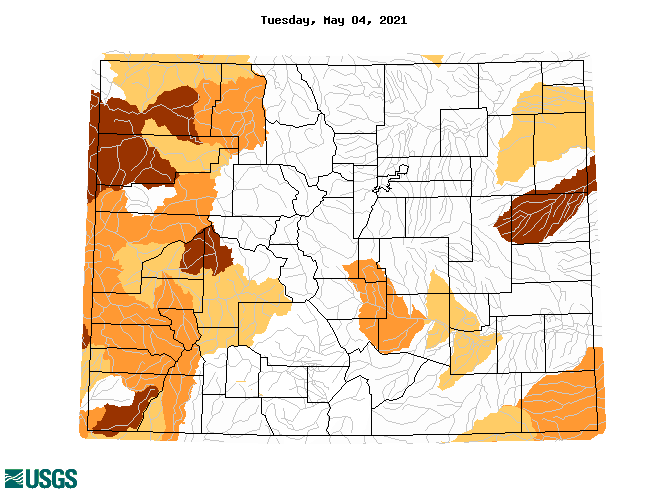
While yesterday was quieter than the previous few days, the last several days of precipitation have certainly helped with drought conditions for at least some portions of Colorado. The map below from USGS represents the normal 7-day average streamflow compared to historical streamflow for Tuesday, May 4. While the Western Slope is still experiencing below normal streamflow to even severe hydrologic drought, much of the Northern, Central, San Juan, and Front Range mountains are experiencing normal streamflow for this time of year.
Flooding was not reported on Tuesday. For rainfall estimates in your area, check out our State Precipitation Map below.
Click Here For Map Overview
The map below shows radar-estimated, rainfall gage-adjusted Quantitative Precipitation Estimates (QPE) across Colorado. The map is updated daily during the operational season (May 1 – Sep 30) by 11AM. The following six layers are currently available: 24-hour, 48-hour and 72-hour total precipitation, as well as maximum 1-hour, 2-hour and 6-hour precipitation over the past 24 hour period (to estimate where flash flooding may have occurred). The accumulation ending time is 7AM of the date shown in the bottom right corner. Also shown optionally are vulnerable fire burn areas (post 2012), which are updated throughout the season to include new, vulnerable burn areas. The home button in the top left corner resets the map to the original zoom.


