Issue Date: 7/21/2015
Issue Time: 10:42 AM
A MODERATE FLOOD THREAT IS FORECAST FOR PORTIONS OF THE FRONT RANGE, URBAN CORRIDOR, PALMER RIDGE, NORTHEAST PLAINS, AND SOUTHEAST PLAINS.
A LOW FLOOD THREAT IS FORECAST FOR PORTIONS OF THE GRAND VALLEY, NORTHWEST SLOPE, NORTHERN MOUNTAINS, CENTRAL MOUNTAINS, FRONT RANGE, URBAN CORRIDOR, NORTHEAST PLAINS, SOUTHEAST PLAINS, PALMER RIDGE, SOUTHEAST MOUNTAINS, AND RATON RIDGE.
There are quite a number of factors at play for today’s forecast, and it leads to a forecast full of caveats. Let’s start by taking a look at the water vapor imagery below; the black line represents the location of a mid-level disturbance, the green line/arrows represent moist, east/southeasterly surface flow, and the “dry air”/white arrow indicate the presence, and motion, of the dry air working in from the southwest. Not shown on the water vapor imagery, but every bit as important, is cloud cover. Timing will mean everything today.
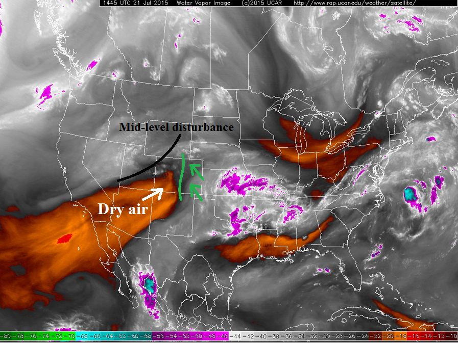
The timing of the shortwave is a concern today, as it is currently sliding across northern Colorado, kicking off scattered showers and thunderstorms. This has also allowed for widespread cloud cover to develop along and east of the Mountains, and this will limit atmospheric instability for those areas underneath the clouds this morning. This will not eliminate the heavy rain threat because moisture values are still sufficiently high. Instead, this will lead to bands of thunderstorms, rather than discrete supercells. This brings in a separate concern for portions of the Urban Corridor, Palmer Ridge, and adjacent portions of the Northeast and Southeast Plains: training/slow-moving thunderstorms.
A surface convergence line will set itself up across those areas this afternoon, providing a focus for thunderstorm development and consistent motion. Due to the limited instability from early cloud cover, rain rates will not be as high as they could be, but training/slow-moving storms will be a concern, and thus, a moderate flood threat has been hoisted for those areas. Additionally, if the shortwave moves through quick enough and allows for clearing skies over the mountains early this afternoon, sunshine will create a corridor of greater instability, which will bring the threat of strong, semi-discrete thunderstorms into play across the Front Range foothills, Urban Corridor, and Palmer Ridge, which would then grow upscale into a mesoscale convective system as it moves east-southeast. With the amount of moisture available, storms that develop in that environment and with that morphology would produce high rainfall rates.
The shortwave will be more favorably timed for afternoon thunderstorms further east over the plains. Combined with greater instability, rain rates will be sufficiently high to warrant a widespread low flood threat. Field and street flooding will be the main concern under strong thunderstorms, especially for areas that received heavy rainfall over the past few days. Low-lying road crossings and streams will need to be monitored for flash flooding issues.
Training thunderstorms are ongoing across the I-70 corridor of western Colorado, producing rainfall at approximately 0.75 inches/hour. As scattered thunderstorms develop this afternoon, this swath will need to be monitored for unstable soil conditions and flash flooding issues. If you weren’t tired of caveats, here is one more for you: the dry air working in from the southwest will begin to push moisture values down across western Colorado this afternoon. Moisture from the north is fighting back against it for the time being, but by later this afternoon/early evening, the dry air will win out. It’s a race against the clock for thunderstorms, and due to this limiting factor, only a low flood threat is warranted.
Today’s Flood Threat Map
For more information on today’s flood threat, see the map below (hover over threat areas for more details). For Zone-Specific forecasts, jump below the map.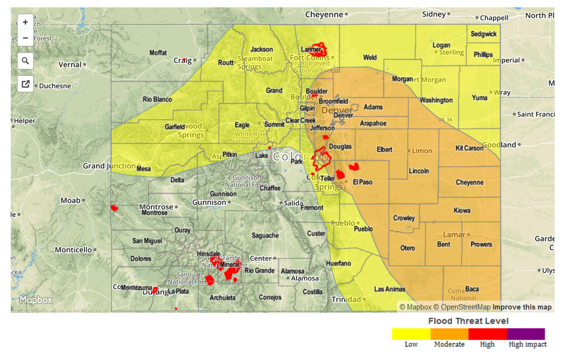
Zone-Specific Forecasts
Front Range, Urban Corridor, Palmer Ridge, Northeast Plains, Southeast Plains, Southeast Mountains, and Raton Ridge:
With a long discussion above, I will focus on rain rates and timing in this section. Maximum rain rates, if all ingredients come together correctly, break down as follows:
Front Range and Southeast Mountains: 1.2-2.0 inches/hour
Urban Corridor, Palmer Ridge, Northeast Plains, Southeast Plains, and Raton Ridge: 2.0-3.0 inches/hour
Timing: 11 AM – Midnight, with a few scattered showers and thunderstorms continuing into the early morning hours.
Northern Mountains, Northwest Slope, Grand Valley, and Central Mountains:
Scattered showers and thunderstorms are ongoing across the I-70 corridor, and will continue through the next few hours. Additional scattered development is likely to begin early this afternoon. Maximum rain rates will be 0.8-1.2 inches/hour.
Timing: 11 AM – 8 PM, with a few scattered showers/weak thunderstorms continuing over the higher terrain into the early morning hours.
San Luis Valley, Southwest Slope, and San Juan Mountains:
Isolated showers and thunderstorms are expected as sunshine increases this afternoon, but rain rates will be lowest across these regions as dry air continues to move in from the southwest. Maximum rain rates will be 0.25-0.6 inches/hour.
Timing: 11 AM – 6 PM