Issue Date: Monday, September 21st, 2020
Issue Time: 9AM MDT
— Flooding is NOT expected today
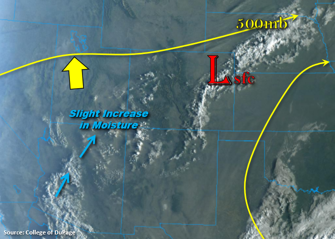
The departing trough can be seen over the eastern plains in the visible satellite imagery below, and radar is showing some light showers occurring along this line of convergence. Behind the trough, another ridge will begin to build northward and slide east throughout the day. Typically, this would begin to dry out the atmosphere and produce subsidence. However, today there are a couple things happening. One, over eastern Colorado, the trough and residual moisture will linger. That means as upslope flow develops this afternoon, there should be enough moisture to help produce another round high-based storms over the eastern mountains and Palmer/Raton Ridges. Secondly, there is some mid-level energy and a slight increase in moisture over southwestern Colorado. As both of these ingredients rotate around a strengthening High to our south, additional storms are forecast over the southern high terrains. With PW values reaching up to 0.50 inches and slow steering winds, rainfall totals should increase a bit when compared to the last couple of days. However, flooding is not forecast. A couple weak thunderstorms are also possible with the main threats being brief, strong outflow winds and lightning.
Today’s Flood Threat Map
For more information on today’s flood threat, see the map below. If there is a threat, hover over the threat areas for more details, and click on burn areas to learn more about them. For Zone-Specific forecasts, scroll below the threat map.

Zone-Specific Forecasts:
San Juan Mountains, Northern Mountains, Central Mountains, Grand Valley, San Luis Valley, Northwest Slope, & Southwest Slope:
Expect scattered cloud cover to increase over the high terrains this afternoon as instability builds. Best chance for precipitation and scattered storms will be over the San Juan and Central Mountains along and near the Continental Divide. The main threats from the stronger storms that develop will be outflow winds and lightning. Isolated rain totals up to 0.30 inches (south) will be possible, but most storms will produce under 0.20 inches. So, flooding is not forecast. Near surface smoke is forecast to intensify along and just south of the northern border.
Primetime: 12:30PM to 8PM
Southeast Mountains, Front Range, Palmer Ridge, Raton Ridge, Urban Corridor, Northeast Plains, & Southeast Plains:
Scattered storms are forecast over the high terrains this afternoon with activity staying mostly south of Clear Creek/Gilpin County. Additional storms are forecast to fire over the Palmer and Raton Ridges where there is the best chance for a weak thunderstorm. Isolated rainfall totals up to 0.50 inches will be possible with most storms producing totals between 0.15 and 0.25 inches. Storms may also produce some brief, but strong outflow winds with the higher cloud bases. Flooding is not forecast. Smoke is forecast to remain over these regions, and near surface smoke looks to remain heavy over the northern Urban Corridor.
Primetime: 1PM to 11PM