Issue Date: Saturday, September 19th, 2020
Issue Time: 10:00AM MDT
— Flooding is NOT expected today
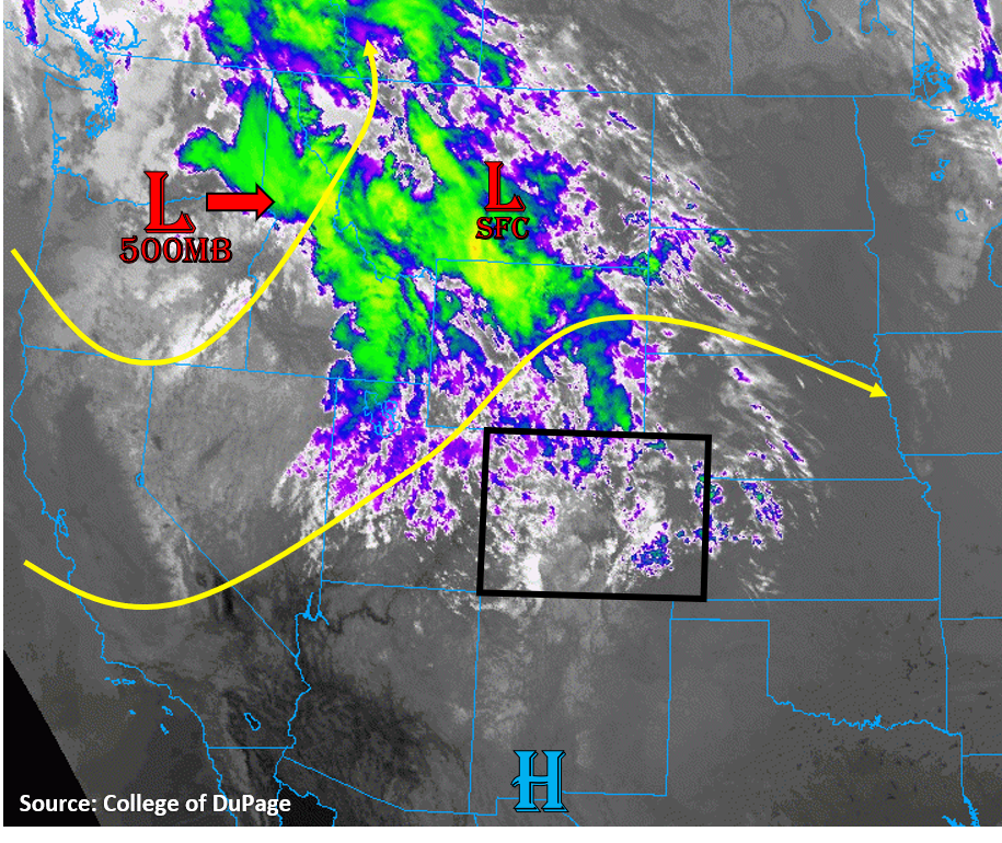
Today a sharp trough will work its way into Colorado, further displacing the high pressure ridge to the south. The upper-level Low at the center of the trough is situated over the Washington/Oregon border as of this morning (see image below). Strong jet stream winds around this upper-level Low are creating plenty of lift and clouds over the Rocky Mountains, as seen by the blue, green, and yellow colors in the infrared satellite image below. This upper-level energy will give northwest Colorado some moderate chances for seeing precipitation today as strong southwesterly upper-level winds work their way into the state from the west. The morning sounding at Grand Junction shows a slight increase in upper-level moisture compared to yesterday with PW of 0.5 inches, but low-level moisture remains week with dew points in the 20Fs. This means any rainfall over the western half of Colorado will struggle with evaporation, limiting rainfall totals. The plains east of the mountains will likely stay mainly dry today due to downslope winds and a dry boundary layer, but a few showers could create virga over the Urban Corridor as they move off the higher terrain. Due to the dry near-surface air and more stratiform nature of rainfall today, no flooding is expected today.
A lee surface Low pressure is developing over eastern Montana, but this low pressure extends south along the eastern Rockies into the adjacent plains all the way through Colorado. This is creating a strong pressure gradient over the eastern plains of Colorado, which will increase surface winds to near 20 mph with gusts up to 35 mph. These strong winds are increasing the fire danger for the eastern plains today with continued warm and dry conditions favoring low humidity, which has caused a Red Flag Warning to be issued by the NWS. Strong surface winds can also be expected over northwestern Colorado as the trough works its way into the state. Additionally, showers that form over the western part of the state could create downdrafts and gusty winds up to 55 mph. This will create an elevated fire danger until precipitation can help moisten the near-surface air.
Today’s Flood Threat Map
For more information on today’s flood threat, see the map below. Hover over the threat areas for more details, and click on burn areas to learn more about them. For Zone-Specific forecasts, scroll below the threat map.

Zone-Specific Forecasts:
Grand Valley, Northwest Slope, Northern Mountains, Front Range, Central Mountains, Southwest Slope, San Juan Mountains, Southeast Mountains, & San Luis Valley:
Light showers are expected over the Northwest Slope and Northern/Central/San Juan Mountains as strong southwesterly upper-level winds associated with the incoming trough create lift. Some weak instability could create more convective showers, but rain rates should stay below 0.3 in/hr. The San Juan Mountains have the highest chances of seeing more convective showers, whereas the Northwest Slope will likely see more stratiform rainfall. Due to dry low-levels, any precipitation will have trouble reaching the ground for the lower elevations, so rain accumulation is most likely for high elevation mountain locations. Additionally, strong winds aloft will keep showers moving quickly. Several rounds of rain are expected starting just before noon and lasting into the overnight hours, so 24-hour rain totals could reach up to 0.4 inches for some of the northern mountain locations. Because of the dry surface layer, strong winds, and weak instability, no flooding is expected today.
The clouds and showers will help keep temperatures down a few degrees, but above normal temperatures are still expected for most locations. Smoke should lessen today, but it is still degrading air quality as of this morning across most regions.
Strong winds will make their way to the surface over the Grand Valley, Northwest Slope, and Northern Mountains with wind gusts likely up to 40 mph, which will increase the fire danger today and could cause some additional growth of the active wildfires in the state. Gusty outflow winds from convective showers could increase these gusts up to 55 mph. Some gusty downslope winds over the Front Range are also expected overnight. Be careful not to cause a spark, and keep an eye on current wildfire conditions today.
Primetime: 11AM to 6AM
Northeast Plains, Urban Corridor, Palmer Ridge, Raton Ridge, & Southeast Plains:
It should stay mainly dry and warm today, with temperatures approaching the 90F mark for many locations. Upper-level clouds will likely be present today, but they should not be thick enough to filter out too much sun. A slight chance for a few showers exists over the western Palmer Ridge and Urban Corridor as mountain showers move east. However, little to no accumulation is expected due to the dry surface conditions. No flooding is expected.
Strong surface winds will affect the eastern portions of the Northeast and Southeast Plains, with gusts up to 35 mph likely. Fire danger is elevated for these regions and a Red Flag Warning is in place. Activities that could initiate sparks should be avoided today. Smoke will continue to degrade air quality today as well.