Issue Date: Saturday, September 12th, 2020
Issue Time: 09:05AM MDT
— Flooding is NOT expected today
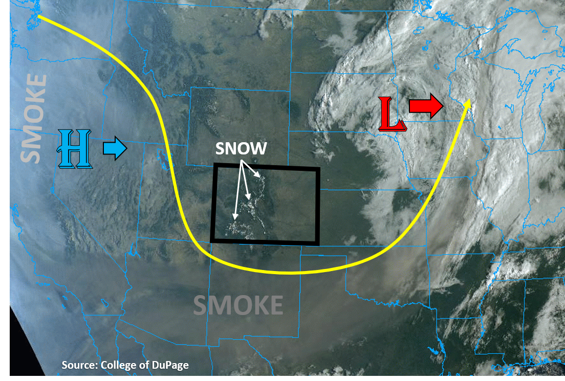
The upper-level Low pressure that has brought beneficial rain and snow to Colorado over the last week is well out of the state this morning, up in eastern South Dakota (see image below). The high-elevation snowfall from this system remains visible on the satellite imagery as well. This dip in the jet stream has fortunately kept the majority of the smoke from wildfires in the West to our west and south, which is very evident in the visible satellite imagery below. Unfortunately, the trough will start to be replaced with a High pressure ridge from the west, which will bring smoke back into Colorado.
Almost no chance of precipitation exists across Colorado today as the departing Low is taking its moisture and lift with it. With temperatures warming a few more degrees today into the 70Fs and low 80Fs (lower elevations), relative humidity will drop this afternoon into the 10% and 20% range as dew points stay in the 20Fs and 30Fs. The only interesting weather today should be some fair weather clouds over the high terrain, with maybe a cell or two producing a brief shower over the high elevations of the southern mountains. Some gusty northerly winds up to 30 mph may impact the northern and eastern plains regions as stronger winds aloft from the departing Low mix down, but winds should die down by evening. Flooding is not expected today.
Today’s Flood Threat Map
For more information on today’s flood threat, see the map below. Hover over the threat areas for more details, and click on burn areas to learn more about them. For Zone-Specific forecasts, scroll below the threat map.

Zone-Specific Forecasts:
Northeast Plains, Urban Corridor, Front Range, Palmer Ridge, Raton Ridge, Southeast Mountains, & Southeast Plains:
Expect mainly sunny skies today with temperatures climbing into the 70Fs and low 80Fs for most low-elevation locations along the plains, which is near to just below seasonal normals. Temperatures will be cooler as you go up in elevation, with temperatures approaching freezing between 13,000 and 14,000 ft. Some winds up to 30 mph could gust over the northern Urban Corridor, Northeast Plains, Palmer Ridge, and eastern Southeast Plains this morning and afternoon, but winds should decrease by evening. Downslope winds just east of the Continental Divide in the Front Range should die down by afternoon. Some afternoon fair weather clouds are possible over the high mountain terrains, but no accumulating rainfall is expected. No flooding is expected today.
Grand Valley, Northwest Slope, Northern Mountains, Central Mountains, Southwest Slope, San Juan Mountains, & San Luis Valley:
Afternoon fair weather clouds will likely build over the high mountaintops and ridgelines, with a shower or two possible for the San Juan, Central, and Southeast Mountains. Any isolated showers that are able to build will not be able to produce significant accumulations, but up to 0.15 inches of 24-hour precipitation accumulation is possible for only the highest elevations. Some of this could fall as a rain/snow mix above 13,000 ft. No flooding is expected.
Temperatures will climb into the mid 70Fs for the lower elevations of the Southwest Slope, Grand Valley, and Northwest Slope, but the air will remain chilly for the San Luis Valley (60Fs) and mountain regions (50Fs & 40Fs). Some smoke may also work its way back into the western and southern part of the state.