Issue Date: Friday, September 11th, 2020
Issue Time: 8:45AM MDT
— Flooding is NOT expected today
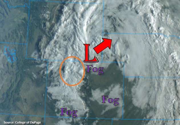
The upper level Low will continue to move northeast and away from the state throughout the day, which will start to clear and warm conditions by this afternoon. Currently, there’s quite a bit of fog over the plains and northern Urban Corridor, and a mix of dense fog and clouds over the mountains. This should start to burn off with a little daytime heating. While conditions will become clear or partly cloudy across the state as the day progresses, a little wrap around moisture and strong upper flow will provide lift over the northern and central mountains for some snow this morning. This should come to an end by about midday. Then, as the Low tracks further east, some light rainfall may be possible along and just south of Colorado’s northern border with some upper level lift on the south side of the Low. Due to the gradual nature of the rainfall, flooding is not forecast.
Today’s Flood Threat Map
For more information on today’s flood threat, see the map below. If there is a threat, hover over the threat areas for more details, and click on burn areas to learn more about them. For Zone-Specific forecasts, scroll below the threat map.

Zone-Specific Forecasts:
Northern Mountains, Central Mountains, Front Range, Urban Corridor, & Northeast Plains:
Some snow showers are forecast this morning over these mountain zones, so an extra couple of inches is possible in the area of the orange oval. The scattered precipitation should come to an end by early afternoon and more sun should return to the forecast later today. Winds look to pick up as well with the upper level jet in the area, so westerly wind gusts around 30 to 35 mph are possible throughout the day over the mountains near the Continental Divide. As the Low progresses east, the precipitation should follow and turn into light rain over the adjacent plains. Some higher totals are likely over the Cheyenne Ridge (isolated totals up to 0.25 inches), but for the most part these should mostly be light, scattered showers. Therefore, flooding is not expected.
Primetime: ongoing to 7PM
Palmer Ridge, Raton Ridge, Southeast Mountains, San Luis Valley, & Southeast Plains:
As the fog and cloud cover begin to decrease throughout the day, more sunshine is expected. That means warmer temperatures by this afternoon. The Southeast Plains will likely reach into the 70Fs with 60Fs for the I-25 Corridor. Over the mountains, highs will be in the upper 50Fs for the valleys. The San Luis Valley will be a bit cooler with highs forecast in the upper 50Fs, and the interior SLV may reach 60F. It should remain dry today, so flooding is not forecast. It may be a bit windy with 15 to 20 mph westerly winds possible over the Southeast Mountains this afternoon, and gusts in the 25 to 30 mph range are possible over the northern portion of the Southeast Mountains.
Grand Valley, Southwest Slope, San Juan Mountains, & Northwest Slope:
It looks like the Grand Valley and lower elevations of the Southwest Slope could reach 70F today with 60Fs for the mountain valleys. Highs will be a bit cooler than this over the higher elevations and the Northwest Slope, and the latter will likely reach into the 60Fs. It could get a little windy along the northern border with the upper level jet in the area, but these stronger winds will likely be confined to the Northern Mountains.