Issue Date: Tuesday, September 8th, 2020
Issue Time: 10:55AM MDT
— A LOW flood threat has been issued for the southern Southwest Slope and San Juan Mountains
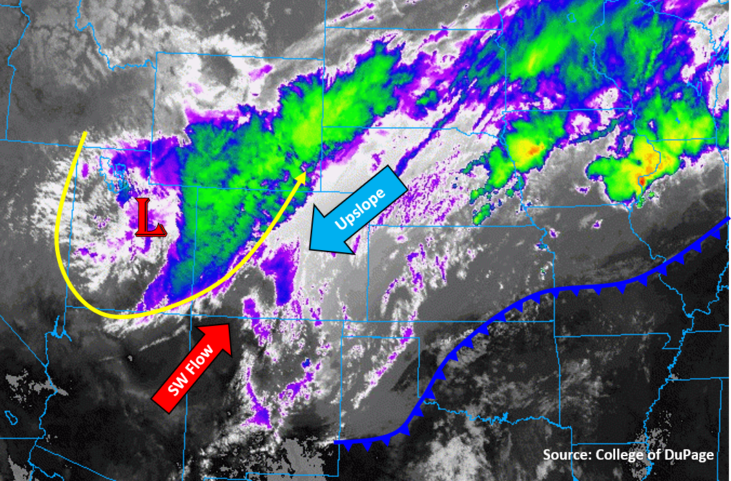
A strong synoptic low pressure system is strengthening over western Colorado and eastern Utah today, which will pump strong southwesterly flow and create lift as it stalls out near the Colorado/Utah border. This lift can already be seen generating a broad thick cloud cover over western Colorado this morning (blue/green colors on infrared satellite image below). This southwesterly flow will draw in some moisture from Arizona to create some instability along the southern San Juan Mountains, where a few bands of heavy convective rainfall could set up late this morning into early afternoon before the snow starts at the higher elevations. This rainfall should transition to snow after a few hours as the freezing level drops, but a Low flood threat has been issued along and south of the Continental Divide in the southern San Juan Mountains and southeastern portion of the Southwest Slope where the thunderstorms and heaviest rainfall are likely to fall. The cold front is working its way into northern and central parts of the mountain regions, which should keep it mainly snowfall for all but the lower elevation valleys of western Colorado.
Cold air and upslope flow over the plains of eastern Colorado are generating rain and snow this morning, with snow already occurring over the Palmer Ridge and mountains. Mixed precipitation will continue today as temperatures likely won’t get out of the 30Fs over the Urban Corridor, Palmer Ridge and Northeast Plains, and 40Fs over the Southeast Plains. Currently it is mainly rain below 6,000 ft elevation, but this will transition over to snow as bands of heavier precipitation move overhead from strong upper-level lift on the east side of this upper-level low. It should transition to all snow for the Urban Corridor during the evening hours as temperatures drop below freezing. The highest snow accumulations by morning will be over the higher elevations, but the Palmer and Raton Ridge will also pick up slightly higher totals. Some isolated locations along the Front Range and much of the high elevations of the Southeast Mountains could see 18-24 inches of snowfall. Due to the mainly steady rain/snow expected over the plains and adjacent mountains, no flooding is expected over these zones.
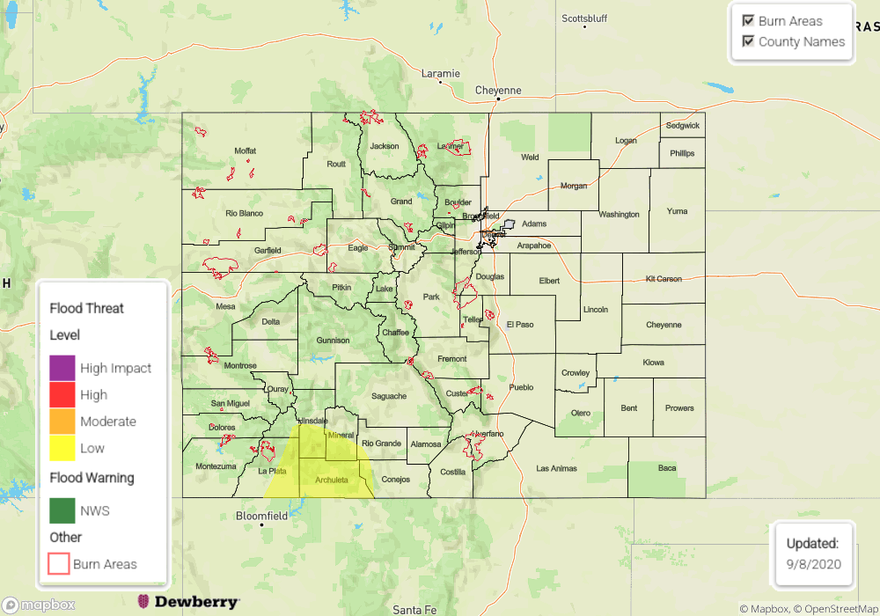
Today’s Flood Threat Map
For more information on today’s flood threat, see the map below. Hover over the threat areas for more details, and click on burn areas to learn more about them. For Zone-Specific forecasts, scroll below the threat map.
Zone-Specific Forecasts:
Grand Valley, Southwest Slope, San Juan Mountains, & San Luis Valley:
It will generally be warmer over these southwestern regions with higher snow lines. Strong southwesterly flow will pump in some moisture and cause some bands of convection to develop over the southern portion of the Southwest Slope and the southern San Juan Mountains. Before switching over to snow, these bands could produce an inch of rain and may produce localized flooding issues. A Low flood threat has been issued for this area. Precipitation should become more widespread and stratiform in nature by late afternoon, which should lower the flood threat. Heavy snowfall is possible over the San Juan Mountains overnight due to the strong cross-mountain wind component favoring enhanced lift, with 12-24 inches possible over the high terrain near the Continental Divide. The western San Juan Valley could get 6-12 inches of snow as well, once the snow line drops to valley level after sunset.
Primetime: ongoing
Northeast Plains, Urban Corridor, Front Range, Palmer Ridge, Raton Ridge, Southeast Mountains, & Southeast Plains:
Heavy snowfall is expected above 6,000 ft along the Front Range and above 7,000 ft along the Southeast Mountains as upslope flow impinges on these mountain ranges behind the strong cold front. With rain transitioning to snow over the immediate adjacent plains later today and tonight, pockets up to 6 inches are possible for the I-25 corridor. Higher totals (6-10 inches) are expected over the higher elevations of the western Palmer and Raton Ridge as well as near the Wyoming border.
Northeasterly surface winds between 15 and 20 mph are also forecast over the eastern plains, which should produce a bit of a wind chill. Precipitation totals (rain) up to 1.50 inches (south) and 0.75 inches (north) are possible by morning. No flooding is expected due to the more gradual accumulation. A hard freeze is likely over much of the region tonight, so tune into your local NWS office for the latest on the warnings issued.
Primetime: ongoing
Northwest Slope, Northern Mountains, & Central Mountains:
Cold air is infiltrating its way into the Northern & Central Mountains and Northwest Slope as the cold front pushing through this mountainous terrain. Strong winds up to 60 mph are being observed along the Northwest Slope behind this cold front. Snow will fall mainly above 9,000 ft elevation over these zones, with 6-12 inches of total snowfall possible by morning, but the slightly higher freezing level over western Colorado will limit snowfall over the lower valleys to just a couple inches or less by morning. No flooding is expected with more stratiform precipitation expected for these zones.
Primetime: ongoing